National Register of Historic Places listings in Lawrence County, Kentucky facts for kids
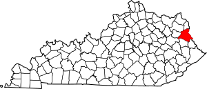
This is a list of the National Register of Historic Places listings in Lawrence County, Kentucky.
This is intended to be a complete list of the properties and districts on the National Register of Historic Places in Lawrence County, Kentucky, United States. The locations of National Register properties and districts for which the latitude and longitude coordinates are included below, may be seen in a map.
There are 10 properties and districts listed on the National Register in the county. Another property was once listed but has been removed.
Current listings
| Name on the Register | Image | Date listed | Location | City or town | Description | |
|---|---|---|---|---|---|---|
| 1 | Atkins-Carter House |
(#88002044) |
314 E. Madison St. 38°06′54″N 82°36′06″W / 38.115000°N 82.601667°W |
Louisa | ||
| 2 | Big Sandy Milling Company |
(#88002045) |
Pike St. between Lock Ave. and railroad tracks 38°07′00″N 82°36′20″W / 38.116667°N 82.605556°W |
Louisa | ||
| 3 | First United Methodist Church |
(#84000391) |
204 W. Main St. 38°06′52″N 82°36′19″W / 38.114444°N 82.605389°W |
Louisa | ||
| 4 | Capt. Freese House |
(#88002042) |
Sycamore St. facing the Big Sandy River 38°07′13″N 82°36′24″W / 38.120139°N 82.606528°W |
Louisa | ||
| 5 | Garred House, Chapel, and Burial Vault |
(#75000790) |
9 miles south of Louisa on U.S. Route 23 38°00′51″N 82°39′34″W / 38.014083°N 82.659444°W |
Louisa | ||
| 6 | Louisa Commercial Historic District |
(#88002041) |
E. Main and Main Cross Sts. 38°06′59″N 82°36′11″W / 38.116389°N 82.603056°W |
Louisa | ||
| 7 | Louisa Residential Historic District |
(#88002040) |
Roughly bounded by Perry, Lock, Madison, and S. Lady Washington Sts. 38°06′54″N 82°36′18″W / 38.115000°N 82.605000°W |
Louisa | ||
| 8 | Louisa United Methodist Church |
(#88002043) |
Main Cross and Madison Sts. 38°06′55″N 82°36′08″W / 38.115139°N 82.602222°W |
Louisa | ||
| 9 | Fred M. Vinson Birthplace |
(#74000890) |
E. Madison and Vinson Ave. 38°06′55″N 82°36′07″W / 38.115278°N 82.601806°W |
Louisa | ||
| 10 | Yatesville Covered Bridge |
(#76000910) |
South of Fallsburg over Blaine Creek off Kentucky Route 3 38°08′41″N 82°41′05″W / 38.144722°N 82.684722°W |
Fallsburg |
Former listing
| Name on the Register | Image | Date listed | Date removed | Location | City or town | Summary | |
|---|---|---|---|---|---|---|---|
| 1 | East Fork Covered Bridge |
(#76000909) |
|
Northwest of Fallsburg over East Fork of Little Sandy River off Kentucky Route 3 |
Fallsburg |

All content from Kiddle encyclopedia articles (including the article images and facts) can be freely used under Attribution-ShareAlike license, unless stated otherwise. Cite this article:
National Register of Historic Places listings in Lawrence County, Kentucky Facts for Kids. Kiddle Encyclopedia.


