State of Palestine facts for kids
Quick facts for kids
State of Palestine
|
|
|---|---|
|
|
|
|
Anthem: فدائي (Fidāʾī; "Fedayeen")
|
|
|
Occupied Palestinian territories (green)
Territory annexed by Israel (light green) |
|
| Status | UN observer state under Israeli occupation Recognized by 146 UN member states |
|
|
| Largest city | Gaza City (before 2023), currently in flux |
| Official languages | Arabic |
| Ethnic groups | Palestinian Arabs |
| Religion
(2014 est.)
|
|
| Demonym(s) | Palestinian |
| Government | Unitary provisional semi-presidential republic |
| Mahmoud Abbas | |
| Mohammad Mustafa | |
|
• Speaker of the Parliament
|
Aziz Dweik |
| Legislature | National Council |
| Formation | |
|
• Declaration of Independence
|
15 November 1988 |
|
• UNGA observer state resolution
|
29 November 2012 |
|
• Sovereignty dispute with Israel
|
Ongoing |
| Area | |
|
• Total
|
6,020 km2 (2,320 sq mi) (163rd) |
|
• Water (%)
|
3.5 |
| 5,655 km2 | |
| 365 km2 | |
| Population | |
|
• 2023 estimate
|
5,483,450 (121st) |
|
• Density
|
731/km2 (1,893.3/sq mi) |
| GDP (PPP) | 2023 estimate |
|
• Total
|
|
|
• Per capita
|
|
| GDP (nominal) | 2021 estimate |
|
• Total
|
|
|
• Per capita
|
|
| Gini (2016) | ▼ 33.7 medium |
| HDI (2021) | high · 106th |
| Currency |
|
| Time zone | UTC+2 (Palestine Standard Time) |
|
• Summer (DST)
|
UTC+3 (Palestine Summer Time) |
| Date format | dd/mm/yyyy |
| Driving side | right |
| Calling code | +970 |
| ISO 3166 code | PS |
| Internet TLD | .ps |
Palestine (Arabic: فلسطين, romanized: Filasṭīn), recognized officially as the State of Palestine (Arabic: دولة فلسطين, romanized: Dawlat Filasṭīn) by the United Nations and other entities, is a de jure sovereign state in Western Asia claiming the West Bank and Gaza Strip with Jerusalem as the designated capital; in practice partial administrative control is held only over the 167 "islands" in the West Bank and the interior of the Gaza Strip, and its administrative center is currently located in Ramallah. The entirety of territory claimed by the State of Palestine has been occupied since 1948, first by Egypt and Jordan and then by Israel after the Six-Day War in 1967. Palestine has a population of 5,051,953 as of February 2020, ranked 121st in the world.
After World War II, in 1947, the UN adopted a Partition Plan for Mandatory Palestine recommending the creation of independent Arab and Jewish states and an internationalized Jerusalem. This partition plan was accepted by the Jews but rejected by the Arabs. The day after the establishment of a Jewish state in Eretz Israel, to be known as the State of Israel on 14 May 1948, neighboring Arab armies invaded the former British mandate and fought the Israeli forces. Later, the All-Palestine Government was established by the Arab League on 22 September 1948 to govern the Egyptian-controlled enclave in Gaza. It was soon recognized by all Arab League members except Transjordan. Though jurisdiction of the Government was declared to cover the whole of the former Mandatory Palestine, its effective jurisdiction was limited to the Gaza Strip. Israel later captured the Gaza Strip and the Sinai Peninsula from Egypt, the West Bank (including East Jerusalem) from Jordan, and the Golan Heights from Syria in June 1967 during the Six-Day War.
On 15 November 1988 in Algiers, Yasser Arafat, Chairman of the Palestine Liberation Organization (PLO), proclaimed the establishment of the State of Palestine. A year after the signing of the Oslo Accords in 1993, the Palestinian National Authority was formed to govern the areas A and B in the West Bank, comprising 165 "islands", and the Gaza Strip. Gaza would later be governed by Hamas in 2007, two years after the Israeli disengagement from Gaza.
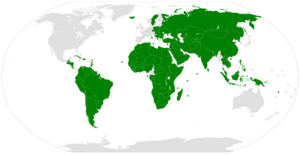
As of June 2024, Palestine is recognized as a sovereign state by 144 out of 193 member states of the United Nations. Palestine is a member of the Arab League, the Organisation of Islamic Cooperation, the G77, the International Olympic Committee, and other international bodies.
Etymology
Although the concept of the Palestine region and its geographical extent has varied throughout history, it is now considered to be composed by the modern State of Israel, the West Bank and the Gaza Strip. General use of the term "Palestine" or related terms to the area at the southeast corner of the Mediterranean Sea beside Syria has historically been taking place since the times of Ancient Greece, with Herodotus being the first historian writing in the 5th century BC in The Histories of a "district of Syria, called Palaistine" in which Phoenicians interacted with other maritime peoples. The term "Palestine" (in Latin, Palæstina) is thought to have been a term coined by the Ancient Greeks for the area of land occupied by the Philistines, although there are other explanations.
Terminology
This article uses the terms "Palestine", "State of Palestine", "occupied Palestinian territory" (oPt or OPT) interchangeably depending on context. Specifically, the term "occupied Palestinian territory" refers as a whole to the geographical area of the Palestinian territory occupied by Israel since 1967. In all cases, any references to land or territory refer to land claimed by the State of Palestine.
History
In 1947, the UN adopted a partition plan for a two-state solution in the remaining territory of the mandate. The plan was accepted by the Jewish leadership but rejected by the Arab leaders, and Britain refused to implement the plan. On the eve of final British withdrawal, the Jewish Agency for Israel declared the establishment of the State of Israel according to the proposed UN plan. The Arab Higher Committee did not declare a state of its own and instead, together with Transjordan, Egypt, and the other members of the Arab League of the time, commenced military action resulting in the 1948 Arab–Israeli War. During the war, Israel gained additional territories that were designated to be part of the Arab state under the UN plan. Egypt occupied the Gaza Strip and Transjordan occupied and then annexed the West Bank. Egypt initially supported the creation of an All-Palestine Government, but disbanded it in 1959. Transjordan never recognized it and instead decided to incorporate the West Bank with its own territory to form Jordan. The annexation was ratified in 1950 but was rejected by the international community. The Six-Day War in 1967, when Israel fought against Egypt, Jordan, and Syria, ended with Israel occupying the West Bank and the Gaza Strip, besides other territories.
In 1964, when the West Bank was controlled by Jordan, the Palestine Liberation Organization was established there with the goal to confront Israel. The Palestinian National Charter of the PLO defines the boundaries of Palestine as the whole remaining territory of the mandate, including Israel. Following the Six-Day War, the PLO moved to Jordan, but later relocated to Lebanon after Black September in 1971.
The October 1974 Arab League summit designated the PLO as the "sole legitimate representative of the Palestinian people" and reaffirmed "their right to establish an independent state of urgency." In November 1974, the PLO was recognized as competent on all matters concerning the question of Palestine by the UN General Assembly granting them observer status as a "non-state entity" at the UN. After the 1988 Declaration of Independence, the UN General Assembly officially acknowledged the proclamation and decided to use the designation "Palestine" instead of "Palestine Liberation Organization" in the UN. In spite of this decision, the PLO did not participate at the UN in its capacity of the State of Palestine's government.
In 1979, through the Camp David Accords, Egypt signaled an end to any claim of its own over the Gaza Strip. In July 1988, Jordan ceded its claims to the West Bank—with the exception of guardianship over Haram al-Sharif—to the PLO. In November 1988, the PLO legislature, while in exile, declared the establishment of the "State of Palestine". In the month following, it was quickly recognised by many states, including Egypt and Jordan. In the Palestinian Declaration of Independence, the State of Palestine is described as being established on the "Palestinian territory", without explicitly specifying further. Because of this, some of the countries that recognised the State of Palestine in their statements of recognition refer to the "1967 borders", thus recognizing as its territory only the occupied Palestinian territory, and not Israel. The UN membership application submitted by the State of Palestine also specified that it is based on the "1967 borders". During the negotiations of the Oslo Accords, the PLO recognised Israel's right to exist, and Israel recognised the PLO as representative of the Palestinian people. Between 1993 and 1998, the PLO made commitments to change the provisions of its Palestinian National Charter that are inconsistent with the aim for a two-state solution and peaceful coexistence with Israel.
After Israel took control of the West Bank from Jordan and Gaza Strip from Egypt, it began to establish Israeli settlements there. These were organised into Judea and Samaria district (West Bank) and Hof Aza Regional Council (Gaza Strip) in the Southern District. Administration of the Arab population of these territories was performed by the Israeli Civil Administration of the Coordinator of Government Activities in the Territories and by local municipal councils present since before the Israeli takeover. In 1980, Israel decided to freeze elections for these councils and to establish instead Village Leagues, whose officials were under Israeli influence. Later this model became ineffective for both Israel and the Palestinians, and the Village Leagues began to break up, with the last being the Hebron League, dissolved in February 1988.
In 1993, in the Oslo Accords, Israel acknowledged the PLO negotiating team as "representing the Palestinian people", in return for the PLO recognizing Israel's right to exist in peace, acceptance of UN Security Council resolutions 242 and 338, and its rejection of "violence and terrorism". As a result, in 1994 the PLO established the Palestinian National Authority (PNA or PA) territorial administration, that exercises some governmental functions in parts of the West Bank and the Gaza Strip. In 2007, the Hamas takeover of Gaza Strip politically and territorially divided the Palestinians, with Abbas's Fatah left largely ruling the West Bank and recognized internationally as the official Palestinian Authority, while Hamas secured its control over the Gaza Strip. In April 2011, the Palestinian parties signed an agreement of reconciliation, but its implementation had stalled until a unity government was formed on 2 June 2014.
As envisioned in the Oslo Accords, Israel allowed the PLO to establish interim administrative institutions in the Palestinian territories, which came in the form of the PNA. It was given civilian control in Area B and civilian and security control in Area A, and remained without involvement in Area C. In 2005, following the implementation of Israel's unilateral disengagement plan, the PNA gained full control of the Gaza Strip with the exception of its borders, airspace, and territorial waters. Following the inter-Palestinian conflict in 2006, Hamas took over control of the Gaza Strip (it already had majority in the PLC), and Fatah took control of the West Bank. From 2007, the Gaza Strip was governed by Hamas, and the West Bank by Fatah.
On 29 November 2012, in a 138–9 vote (with 41 abstentions and 5 absences), the United Nations General Assembly passed resolution 67/19, upgrading Palestine from an "observer entity" to a "non-member observer state" within the United Nations system, which was described as recognition of the PLO's sovereignty. Palestine's new status is equivalent to that of the Holy See.
On 17 December 2012, UN Chief of Protocol Yeocheol Yoon declared that "the designation of 'State of Palestine' shall be used by the Secretariat in all official United Nations documents", thus recognising the title 'State of Palestine' as the state's official name for all UN purposes; on 21 December 2012, a UN memorandum discussed appropriate terminology to be used following GA 67/19. It was noted therein that there was no legal impediment to using the designation Palestine to refer to the geographical area of the Palestinian territory. At the same time, it was explained that there was also no bar to the continued use of the term "Occupied Palestinian Territory including East Jerusalem" or such other terminology as might customarily be used by the Assembly. As of 3 August 2018, 137 (71%) of the 193 member states of the United Nations have recognised the State of Palestine. Many of the countries that do not recognise the State of Palestine nevertheless recognise the PLO as the "representative of the Palestinian people". The PLO's Executive Committee is empowered by the Palestinian National Council to perform the functions of government of the State of Palestine.
Geography
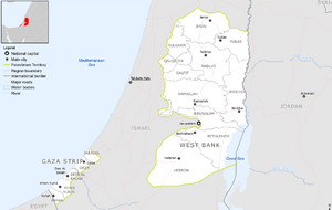
The areas claimed by the State of Palestine lie in the Levant. The Gaza Strip borders the Mediterranean Sea to the west, Egypt to the south, and Israel to the north and east. The West Bank is bordered by Jordan to the east, and Israel to the north, south, and west. Thus, the two enclaves constituting the area claimed by State of Palestine have no geographical border with one another, being separated by Israel. These areas would constitute the world's 163rd largest country by land area.
Palestine has a number of environmental issues; issues facing the Gaza Strip include desertification; salination of fresh water; sewage treatment; water-borne diseases; soil degradation; and depletion and contamination of underground water resources. In the West Bank, many of the same issues apply; although fresh water is much more plentiful, access is restricted by the ongoing dispute.
Three terrestrial ecoregions are found in the area: Eastern Mediterranean conifer-sclerophyllous-broadleaf forests, Arabian Desert, and Mesopotamian shrub desert.
Climate
Temperatures in Palestine vary widely. The climate in the West Bank is mostly Mediterranean, slightly cooler at elevated areas compared with the shoreline, west to the area. In the east, the West Bank includes much of the Judean Desert including the western shoreline of the Dead Sea, characterised by dry and hot climate. Gaza has a hot semi-arid climate (Köppen: BSh) with mild winters and dry hot summers. Spring arrives around March–April and the hottest months are July and August, with the average high being 33 °C (91 °F). The coldest month is January with temperatures usually at 7 °C (45 °F). Rain is scarce and generally falls between November and March, with annual precipitation rates approximately at 4.57 inches (116 mm).
Government and politics
The State of Palestine consists of the following institutions that are associated with the Palestine Liberation Organization (PLO):
- President of the State of Palestine – appointed by the Palestinian Central Council
- Palestinian National Council – the legislature that established the State of Palestine
- Executive Committee of the Palestine Liberation Organization – performs the functions of a government in exile, maintaining an extensive foreign-relations network
These should be distinguished from the President of the Palestinian National Authority, Palestinian Legislative Council (PLC) and PNA Cabinet, all of which are instead associated with the Palestinian National Authority.
The State of Palestine's founding document is the Palestinian Declaration of Independence, and it should be distinguished from the unrelated PLO Palestinian National Covenant and PNA Palestine Basic Law.
On 26 February 2024, the Palestinian government collapsed, with the entire Palestinian government resigning, including the prime minister.
Administrative divisions
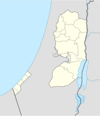
The State of Palestine is divided into sixteen administrative divisions.
| Name | Area (km2) | Population | Density (per km2) | Muhafazah (district capital) |
|---|---|---|---|---|
| Jenin | 583 | 311,231 | 533.8 | Jenin |
| Tubas | 402 | 64,719 | 161.0 | Tubas |
| Tulkarm | 246 | 182,053 | 740.0 | Tulkarm |
| Nablus | 605 | 380,961 | 629.7 | Nablus |
| Qalqiliya | 166 | 110,800 | 667.5 | Qalqilya |
| Salfit | 204 | 70,727 | 346.7 | Salfit |
| Ramallah & Al-Bireh | 855 | 348,110 | 407.1 | Ramallah |
| Jericho & Al Aghwar | 593 | 52,154 | 87.9 | Jericho |
| Jerusalem | 345 | 419,108a | 1214.8a | Jerusalem (de Jure) |
| Bethlehem | 659 | 216,114 | 927.9 | Bethlehem |
| Hebron | 997 | 706,508 | 708.6 | Hebron |
| North Gaza | 61 | 362,772 | 5947.1 | Jabalya |
| Gaza | 74 | 625,824 | 8457.1 | Gaza City |
| Deir Al-Balah | 58 | 264,455 | 4559.6 | Deir al-Balah |
| Khan Yunis | 108 | 341,393 | 3161.0 | Khan Yunis |
| Rafah | 64 | 225,538 | 3524.0 | Rafah |
a. Data from Jerusalem includes occupied East Jerusalem with its Israeli population
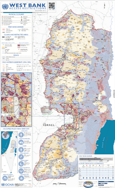
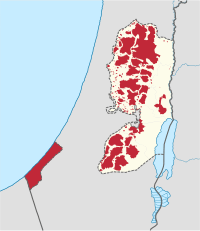
The governorates in the West Bank are grouped into three areas per the Oslo II Accord. Area A forms 18% of the West Bank by area, and is administered by the Palestinian government. Area B forms 22% of the West Bank, and is under Palestinian civil control, and joint Israeli-Palestinian security control. Area C, except East Jerusalem, forms 60% of the West Bank, and is administered by the Israeli Civil Administration, except that the Palestinian government provides the education and medical services to the 150,000 Palestinians in the area. More than 99% of Area C is off limits to Palestinians. There are about 330,000 Israelis living in settlements in Area C, in the Judea and Samaria Area. Although Area C is under martial law, Israelis living there are judged in Israeli civil courts.
East Jerusalem (comprising the small pre-1967 Jordanian eastern-sector Jerusalem municipality together with a significant area of the pre-1967 West Bank demarcated by Israel in 1967) is administered as part of the Jerusalem District of Israel, but is claimed by Palestine as part of the Jerusalem Governorate. It was effectively annexed by Israel in 1967, by application of Israeli law, jurisdiction and administration under a 1948 law amended for the purpose, this purported annexation being constitutionally reaffirmed (by implication) in Basic Law: Jerusalem 1980, but this annexation is not recognised by any other country. In 2010 of the 456,000 people in East Jerusalem, roughly 60% were Palestinians and 40% were Israelis. However, since the late 2000s, Israel's West Bank Security Barrier has effectively re-annexed tens of thousands of Palestinians bearing Israeli ID cards to the West Bank, leaving East Jerusalem within the barrier with a small Israeli majority.
Foreign relations
Representation of the State of Palestine is performed by the Palestine Liberation Organization (PLO). In states that recognise the State of Palestine it maintains embassies. The Palestine Liberation Organization is represented in various international organizations as member, associate or observer. Because of inconclusiveness in sources in some cases it is impossible to distinguish whether the participation is executed by the PLO as representative of the State of Palestine, by the PLO as a non-state entity or by the PNA.
International recognition
The State of Palestine has been recognized by 145 of the 193 UN members and since 2012 has had a status of a non-member observer state in the United Nations.
On 29 November 2012, in a 138–9 vote (with 41 abstentions and 5 absences), the United Nations General Assembly passed resolution 67/19, upgrading Palestine from an "observer entity" to a "non-member observer state" within the United Nations System, which was described as recognition of the PLO's sovereignty. Palestine's new status is equivalent to that of the Holy See.
The UN has permitted Palestine to title its representative office to the UN as "The Permanent Observer Mission of the State of Palestine to the United Nations", and Palestine has instructed its diplomats to officially represent "The State of Palestine"—no longer the Palestinian National Authority. On 17 December 2012, UN Chief of Protocol Yeocheol Yoon declared that "the designation of 'State of Palestine' shall be used by the Secretariat in all official United Nations documents", thus recognising the title 'State of Palestine' as the state's official name for all UN purposes; on 21 December 2012, a UN memorandum discussed appropriate terminology to be used following GA 67/19. It was noted therein that there was no legal impediment to using the designation Palestine to refer to the geographical area of the Palestinian territory. At the same time, it was explained that there was also no bar to the continued use of the term "Occupied Palestinian Territory including East Jerusalem" or such other terminology as might customarily be used by the Assembly. As of 3 August 2018, 137 (71%) of the 193 member states of the United Nations have recognised the State of Palestine. Many of the countries that do not recognise the State of Palestine nevertheless recognise the PLO as the "representative of the Palestinian people". The PLO's Executive Committee is empowered by the Palestinian National Council to perform the functions of government of the State of Palestine.
On 2 April 2024, Riyad Mansour, the Palestinian ambassador to the UN, requested that the Security Council consider a renewed application for membership, supported by the 22-nation Arab Group at the United Nations, the 57-nation Organization of Islamic Cooperation, and the 120-member Nonaligned Movement. As of April, seven of the council's 15 members recognize the state of Palestine but the US has indicated that it opposes the request and in addition, US law stipulates that US funding for the UN would be cut off in the event of full recognition without an Israeli-Palestinian agreement. On 18 April, the US vetoed a widely supported UN resolution that would have admitted Palestine as a full UN member.
Raising the flag at the UN
In August 2015, Palestine's representatives at the UN presented a draft resolution that would allow the non-member observer states Palestine and the Holy See to raise their flags at the United Nations headquarters. Initially, the Palestinians presented their initiative as a joint effort with the Holy See, which the Holy See denied.
In a letter to the Secretary General and the President of the General Assembly, Israel's Ambassador at the UN Ron Prosor called the step "another cynical misuse of the UN ... in order to score political points".
After the vote, which was passed by 119 votes to 8 with 45 countries abstaining, the US Ambassador Samantha Power said that "raising the Palestinian flag will not bring Israelis and Palestinians any closer together". US Department of State spokesman Mark Toner called it a "counterproductive" attempt to pursue statehood claims outside of a negotiated settlement.
At the ceremony itself, U.N. Secretary-General Ban Ki-moon said the occasion was a "day of pride for the Palestinian people around the world, a day of hope", and declared "Now is the time to restore confidence by both Israelis and Palestinians for a peaceful settlement and, at last, the realization of two states for two peoples."
Legal status
There are a wide variety of views regarding the status of the State of Palestine, both among the states of the international community and among legal scholars. The existence of a state of Palestine, although controversial, is a reality in the opinions of the states that have established bilateral diplomatic relations.
Law and security
The State of Palestine has a number of security forces, including a Civil Police Force, National Security Forces and Intelligence Services, with the function of maintaining security and protecting Palestinian citizens and the Palestinian State.
Demographics
| Population | |||
|---|---|---|---|
| Year | Million | ||
| 1950 | 0.9 | ||
| 2000 | 3.2 | ||
| 2018 | 4.9 | ||
According to the Palestinian Central Bureau of Statistics, the State of Palestine had population of 4,420,549 people in 2013. Within an area of 6,020 square kilometres (2,320 sq mi), there is a population density of about 827 people per square kilometre. To put this in a wider context, the average population density of the world was 25 people per square kilometre as of 2017.
Healthcare
According to the Palestinian Ministry of Health (MOH), as of 2017, there were 743 primary health care centers in Palestine (583 in the West Bank and 160 in Gaza), and 81 hospitals (51 in the West Bank, including East Jerusalem, and 30 in Gaza).
Operating under the auspices of the World Health Organization (WHO), the Health Cluster for the occupied Palestinian territory (oPt) was established in 2009 and represents a partnership of over 70 local and international nongovernmental organisations and UN agencies providing a framework for health actors involved in the humanitarian response for the oPt. The Cluster is co-chaired by the MOH to ensure alignment with national policies and plans. The report of WHO Director-General of 1 May 2019 describes health sector conditions in the oPt identifying strategic priorities and current obstacles to their achievement pursuant to the country cooperation strategy for WHO and the Occupied Palestinian Territory 2017–2020.
Education
The literacy rate of Palestine was 96.3% according to a 2014 report by the United Nations Development Programme, which is high by international standards. There is a gender difference in the population aged above 15 with 5.9% of women considered illiterate compared to 1.6% of men. Illiteracy among women has fallen from 20.3% in 1997 to less than 6% in 2014.
Religion
Religion of Palestinians (est. 2014) Islam (93%) Christianity (6%) Druze and Samaritans (1%)
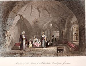
93% of Palestinians are Muslim, the vast majority of whom are followers of the Sunni branch of Islam, with a small minority of Ahmadiyya, and 15% being nondenominational Muslims. Palestinian Christians represent a significant minority of 6%, followed by much smaller religious communities, including Druze and Samaritans.
Economy
Tourism
Tourism in the territory claimed by State of Palestine refers to tourism in East Jerusalem, the West Bank and the Gaza Strip. In 2010, 4.6 million people visited the Palestinian territories, compared to 2.6 million in 2009. Of that number, 2.2 million were foreign tourists while 2.7 million were domestic. Most tourists come for only a few hours or as part of a day trip itinerary. In the last quarter of 2012 over 150,000 guests stayed in West Bank hotels; 40% were European and 9% were from the United States and Canada. Lonely Planet travel guide writes that "the West Bank is not the easiest place in which to travel but the effort is richly rewarded." In 2013 Palestinian Authority Tourism minister Rula Ma'ay'a stated that her government aims to encourage international visits to Palestine, but the occupation is the main factor preventing the tourism sector from becoming a major income source to Palestinians. There are no visa conditions imposed on foreign nationals other than those imposed by the visa policy of Israel. Access to Jerusalem, the West Bank, and Gaza is completely controlled by the Government of Israel. Entry to the occupied Palestinian territories requires only a valid international passport.
Communications
The Palestinian Central Bureau of Statistics (PCBS) and the Ministry of Telecom and Information Technology said there were 4.2 million cellular mobile subscribers in Palestine compared to 2.6 million at the end of 2010 while the number of ADSL subscribers in Palestine increased to about 363 thousand by the end of 2019 from 119 thousand over the same period. 97% of Palestinian households have at least one cellular mobile line while at least one smartphone is owned by 86% of households (91% in the West Bank and 78% in Gaza Strip). About 80% of the Palestinian households have access to internet at their homes and about a third have a computer. On 12 June 2020, the World Bank approved a US$15 million grant for the Technology for Youth and Jobs (TechStart) Project aiming to help the Palestinian IT sector upgrade the capabilities of firms and create more high-quality jobs. Kanthan Shankar, World Bank Country Director for West Bank and Gaza said "The IT sector has the potential to make a strong contribution to economic growth. It can offer opportunities to Palestinian youth, who constitute 30% of the population and suffer from acute unemployment."
Financial services
The Palestine Monetary Authority has issued guidelines for the operation and provision of electronic payment services including e-wallet and prepaid cards.
Transportation
Railways
There are no operating railways in the Palestinian territories.
The Camp David agreements, and repeated in statements made by Israel in 2005, there was a proposal to link the two Palestinian territories with a high speed rail line. This would involve extending the Heletz railway to Tarqumiyah (thus providing a rail link from Erez Crossing to the West Bank) and building a spur for the future Eastern Railway to Tulkarm, as well as rebuilding the old railway branch from a renewed Jezreel Valley Railway to Jenin. These links might be extended later through to Egypt and Jordan.
As of February 2012[update], a plan for a 475-kilometer rail network, establishing 11 new rail lines in West Bank, was confirmed by Israeli Transportation Ministry. The West Bank network would include one line running through Jenin, Nablus, Ramallah, Jerusalem, Ma'aleh Adumim, Bethlehem and Hebron. Another would provide service along the Jordanian border from Eilat to the Dead Sea, Jericho and Beit She'an and from there toward Haifa in the west and in also in a northeasterly direction. The proposed scheme also calls for shorter routes, such as between Nablus and Tulkarm in the West Bank, and from Ramallah to the Allenby Bridge crossing into Jordan.
History
The Gaza Strip had a standard-gauge railway running 34 kilometers along its length from north to south, which was built in 1916. Prior to 1948 and from about 1972 until an unknown date the line connected to what then became the Israeli system to the north. It also connected to the Egyptian railway system to the south from 1916 to 1967. The line has now been dismantled.
In the West Bank, a narrow-gauge railway operated until the 1940s from Jenin to Tulkarm and Nablus, which was built during Ottoman rule, and connected to the Hejaz Railway on a 1,050 mm (3 ft 5 11⁄32 in) gauge.
Links with adjacent countries
Several defunct railways in the Palestinian territories were previously used to link with adjacent countries:
 see Israel
- A standard gauge rail link between Israel and Gaza through the Erez Crossing operated until the early 1970s. The railway has been dismantled in the Gaza Strip, and on the Israeli side Israel Railways' active railway line ends about 4.5 km northeast of the crossing, though in the future it may be re-extended to the crossing to provide a cargo service to the Gaza Strip.
-
- The narrow gauge Jezreel Valley Railway branch from Afula to Jenin operated until the 1940s. Also, until the late 1940s, a gauge break existed in Tulkarm between the Jenin—Tulkarm—Nablus narrow gauge railway and the standard gauge Eastern Railway. All these connections are now defunct.
Roadways
In 2010, the West Bank and Gaza Strip together had 4,686 km (2,912 mi) of roadways.
Salah al-Din Road, also known as the Salah ad-Deen Highway, is the main highway of the Gaza Strip. It is 45 kilometers long, and runs the entire length of the Gaza Strip from the Erez Crossing to Israel in the north to the Rafah Crossing to Egypt in the south.
Ports and harbors
The West Bank is landlocked and has no ports.
The Port of Gaza is a small port near the Rimal district of Gaza City. It is the home port of Palestinian fishing-boats and the base of the Palestinian Naval Police, a branch of the Palestinian National Security Forces. Under the Oslo II Accord, the activities of the Palestinian Naval Police are restricted to 6 nautical miles from the coast. The Port of Gaza has been under naval blockade since 2007, and activities at the port have been restricted to small-scale fishing.
Construction of the Gaza Seaport had begun in the Gaza Strip, but the building was destroyed and the project abandoned after the outbreak of the Second Intifada in September 2000. There are no ships in the Gaza Strip over 1,000 gross tons.
Airports
There are three airports in the Palestinian territories, all of which are presently closed. The Yasser Arafat International Airport (previously called Gaza International Airport), located in the Gaza Strip, was opened on 24 November 1998 as part of the Oslo II Accord and the 23 October 1998 Wye River Memorandum. The airport was closed in October 2000 by Israeli order, after the breakout of the Second Intifada. Its runway was destroyed by the Israel Defense Forces in December 2001. Atarot Airport was also closed in 2000. Gush Katif Airport, also in the Gaza Strip, was closed in 2004.
West Bank Palestinians traveling abroad can use the Allenby Bridge to enter Jordan and then use the Queen Alia International Airport in Amman to fly abroad.
Border crossings
The Allenby Bridge, also known as the Al-Karameh Bridge and the King Hussein Bridge, is a bridge that crosses the Jordan River near the city of Jericho, and connects the West Bank with Jordan. The bridge is currently the sole designated exit/entry point for West Bank Palestinians traveling abroad. Since the 1994 Israel–Jordan peace treaty, the Allenby Bridge Terminal has been operated by the Israel Airports Authority.
The Erez Crossing, Karni Crossing and the Kerem Shalom Crossing are three border crossings on the Israel-Gaza Strip barrier between the Gaza Strip and Israel, and have been affected by the Israeli Blockade of the Gaza Strip. The Rafah Crossing is the only land crossing between the Gaza Strip and Egypt.
- The Erez Crossing is the only land crossing for the movement of people between the Gaza Strip and Israel, as well as third countries when the Rafah Crossing is closed.
- The Karni Crossing was a cargo terminal on the Israel-Gaza Strip barrier located in the north-eastern end of the Gaza Strip. It was opened in 1994 after the signing of the Oslo Accords to allow Palestinian merchants to export and import goods. This was done as a 'back-to-back' transfer, meaning that Palestinian products meant for export were removed from a Palestinian truck and placed in an Israeli truck, or vice versa for incoming goods. Israel closed the Karni Crossing after Hamas took over the Gaza Strip in June 2007, and the closure was made permanent at the end of March 2011.
- The Kerem Shalom Crossing was used by trucks carrying goods from Israel to the Gaza Strip.
Water supply and sanitation
Water supply and sanitation in the Palestinian territories are characterized by severe water shortage and are highly influenced by the Israeli occupation. The water resources of Palestine are fully controlled by Israel and the division of groundwater is subject to provisions in the Oslo II Accord.
Generally, the water quality is considerably worse in the Gaza strip when compared to the West Bank. About a third to half of the delivered water in the Palestinian territories is lost in the distribution network. The lasting blockade of the Gaza Strip and the Gaza War have caused severe damage to the infrastructure in the Gaza Strip. Concerning wastewater, the existing treatment plants do not have the capacity to treat all of the produced wastewater, causing severe water pollution. The development of the sector highly depends on external financing.
Culture
Media
There are a number of newspapers, news agencies, and satellite television stations in the State of Palestine. News agencies include Ma'an News Agency, Wafa, Palestine News Network and the satellite television includes Al-Aqsa TV, Al-Quds TV, Sanabel TV.
Sports
Football (Soccer in the United States) is the most popular sport among the Palestinian people. Rugby is also a popular sport. The Palestine national football team represents the country in international football.
See also
 In Spanish: Estado de Palestina para niños


