West Bank facts for kids

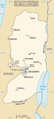
The West Bank is a piece of land in the Middle East. It touches the Dead Sea and the River Jordan. The landscape is mostly hills or desert. The weather in the summer is hot and dry. It is cooler and rainy in the winter. Right now, the area is under the control of Israel. Some Israelis and other nations disagree on whose it really is. Since 1990 there are talks between the Israeli government and the Palestinians about what will happen in the West Bank and the Gaza Strip in the future. Most people on the West Bank are Palestinians but there are also many Jewish settlers in settlements. There has been some controversy about these settlements.
The State of Palestine claims the West Bank with East Jerusalem included.
The West Bank is called Judea and Samaria Area by the Israeli government.
Images for kids
-
City of Bethlehem, West Bank
-
King Hussein flying over the Temple Mount in Jerusalem when it was under Jordanian control, 1965
-
City of Jericho, West Bank
-
U.S. President George Bush and Mahmoud Abbas in Ramallah, 2008
-
View of the Judaean Mountains from Ramallah
-
Map of West Bank settlements and closures in January 2006: Yellow = Palestinian urban centers. Light pink = closed military areas or settlement boundary areas or areas isolated by the Israeli West Bank barrier; dark pink = settlements, outposts or military bases. The black line = route of the Barrier
-
Greater Jerusalem, May 2006. CIA remote sensing map showing areas considered settlements, plus refugee camps, fences, walls, etc.
-
West Bank barrier (Separating Wall)
-
Palestinian girl in Nablus
-
Checkpoint before entering Jericho, 2005
See also
 In Spanish: Cisjordania para niños


