Nauru facts for kids
Quick facts for kids
Republic of Nauru
Repubrikin Naoero (Nauruan)
|
|
|---|---|
|
|
|
|
Motto: "God's will first"
|
|
|
Anthem: Nauru Bwiema
"Nauru, our homeland" |
|
 |
|
| Capital | None (de jure) Yaren (de facto) 0°31′39″S 166°56′06″E / 0.52750°S 166.93500°E |
| Largest city | Denigomodu |
| Official languages |
|
| Demonym(s) | Nauruan |
| Government | Unitary parliamentary republic with an executive presidency under a non-partisan democracy |
| David Adeang | |
| Marcus Stephen | |
| Legislature | Parliament |
| Independence | |
|
• Nauru Independence Act 1967
|
31 January 1968 |
| Area | |
|
• Total
|
21 km2 (8.1 sq mi) (193rd) |
|
• Water (%)
|
0.57 |
| Population | |
|
• 2024 estimate
|
11,919 (227th) |
|
• 2011 census
|
10,084 |
|
• Density
|
480/km2 (1,243.2/sq mi) (25th) |
| GDP (PPP) | 2021 estimate |
|
• Total
|
$132 million (192nd) |
|
• Per capita
|
$9,995 (94th) |
| GDP (nominal) | 2022 estimate |
|
• Total
|
$150 million |
|
• Per capita
|
$10,125 |
| HDI (2022) | medium · 122nd |
| Currency | Australian dollar (AUD) |
| Time zone | UTC+12 |
| Driving side | left |
| Calling code | +674 |
| ISO 3166 code | NR |
| Internet TLD | .nr |
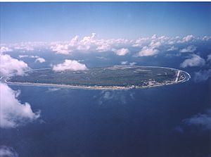
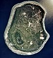
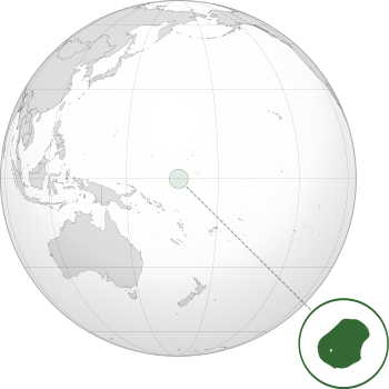
Nauru, officially the Republic of Nauru, is a sovereign island nation located in the Micronesian South Pacific. Its nearest neighbour is Banaba Island in the Republic of Kiribati, 300 kilometres (190 mi) due east. Nauru is the world's smallest island nation, covering just 21 square kilometres (8 sq mi), the smallest independent republic, and the only republican state in the world without an official capital. With 10,670 residents, it is the third least-populated country after Vatican City and Tuvalu.
It sells phosphate (a chemical) to Australia. English and Nauruan are the official languages of Nauru.
Contents
History
Settled by Micronesians circa 1000 BCE, Nauru was annexed and claimed as a colony by the German Empire in the late 19th century. After World War I, Nauru became a League of Nations mandate administered by Australia, New Zealand, and the United Kingdom. During World War II, Nauru was occupied by Japanese troops, and was bypassed by the Allied advance across the Pacific. After the war ended, the country entered into United Nations trusteeship. Nauru gained its independence in 1968 and joined the United Nations in 1999.
Geography
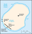
Nauru is a 21 square kilometres (8 sq mi) oval-shaped island in the southwestern Pacific Ocean, 42 kilometres (26 mi) south of the Equator. The island is surrounded by a coral reef, which is exposed at low tide and dotted with pinnacles. The presence of the reef has prevented the establishment of a seaport, although channels in the reef allow small boats access to the island. A fertile coastal strip 150 to 300 metres (490 to 980 ft) wide lies inland from the beach.
Coral cliffs surround Nauru's central plateau. The highest point of the plateau, called the Command Ridge, is 71 metres (233 ft) above sea level. The only fertile areas on Nauru are on the narrow coastal belt, where coconut palms flourish. The land surrounding Buada Lagoon supports bananas, pineapples, vegetables, pandanus trees, and indigenous hardwoods such as the tomano tree.
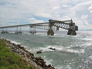
Nauru was one of three great phosphate rock islands in the Pacific Ocean (the others were Banaba (Ocean Island) in Kiribati and Makatea in French Polynesia). The phosphate reserves on Nauru are now almost entirely depleted. Phosphate mining in the central plateau has left a barren terrain of jagged limestone pinnacles up to 15 metres (49 ft) high. Mining has stripped and devastated about 80 per cent of Nauru's land area, and has also affected the surrounding Exclusive Economic Zone; 40 per cent of marine life is estimated to have been killed by silt and phosphate runoff.
There are only about 60 recorded vascular plant species native to the island, none of which are endemic. Coconut farming, mining, and introduced species have caused serious disturbance to the native vegetation. There are no native land mammals, but there are native insects, land crabs, and birds, including the endemic Nauru Reed Warbler. The Polynesian rat, cats, dogs, pigs, and chickens have been introduced to Nauru from ships.
There are limited natural fresh water resources on Nauru. Rooftop storage tanks collect rainwater, but the islanders are mostly dependent on three desalination plants housed at Nauru's Utilities Agency. Nauru's climate is hot and very humid year-round because of its proximity to the equator and the ocean. Nauru is hit by monsoon rains between November and February, but does not typically experience cyclones. Annual rainfall is highly variable and is influenced by the El Niño-Southern Oscillation, with several significant recorded droughts. The temperature on Nauru ranges between 26 °C (79 °F) and 35 °C (95 °F) during the day and between 22 °C (72 °F) and 34 °C (93 °F) at night.
As an island, Nauru is vulnerable to climate and sea level change. Nauru is the seventh most global warming threatened nation due to flooding. At least 80 per cent of the land of Nauru is well elevated, but this area will be uninhabitable until the phosphate mining rehabilitation programme is implemented.
| Climate data for Yaren District, Nauru | |||||||||||||
|---|---|---|---|---|---|---|---|---|---|---|---|---|---|
| Month | Jan | Feb | Mar | Apr | May | Jun | Jul | Aug | Sep | Oct | Nov | Dec | Year |
| Record high °C (°F) | 34 (93) |
37 (99) |
35 (95) |
35 (95) |
32 (90) |
32 (90) |
35 (95) |
33 (91) |
35 (95) |
34 (93) |
36 (97) |
35 (95) |
37 (99) |
| Mean daily maximum °C (°F) | 30 (86) |
30 (86) |
30 (86) |
30 (86) |
30 (86) |
30 (86) |
30 (86) |
30 (86) |
30 (86) |
31 (88) |
31 (88) |
31 (88) |
30 (87) |
| Mean daily minimum °C (°F) | 25 (77) |
25 (77) |
25 (77) |
25 (77) |
25 (77) |
25 (77) |
25 (77) |
25 (77) |
25 (77) |
25 (77) |
25 (77) |
25 (77) |
25 (77) |
| Record low °C (°F) | 21 (70) |
21 (70) |
21 (70) |
21 (70) |
20 (68) |
21 (70) |
20 (68) |
21 (70) |
20 (68) |
21 (70) |
21 (70) |
21 (70) |
20 (68) |
| Average precipitation mm (inches) | 280 (11.0) |
250 (9.8) |
190 (7.5) |
190 (7.5) |
120 (4.7) |
110 (4.3) |
150 (5.9) |
130 (5.1) |
120 (4.7) |
100 (3.9) |
120 (4.7) |
280 (11.0) |
2,080 (81.9) |
| Average precipitation days | 16 | 14 | 13 | 11 | 9 | 9 | 12 | 14 | 11 | 10 | 13 | 15 | 152 |
| Source: [1] | |||||||||||||
Politics
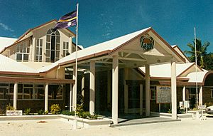
Nauru is a republic with a parliamentary system of government. The president is both head of state and head of government and is dependent on parliamentary confidence to remain president. All 19 parliament seats are elected every three years. The parliament elects the president from its members, and the president appoints a cabinet of five to six members.
Nauru's Supreme Court, headed by the Chief Justice, is paramount on constitutional issues. Other cases can be appealed to the two-judge Appellate Court. Parliament cannot overturn court decisions.
Administrative divisions
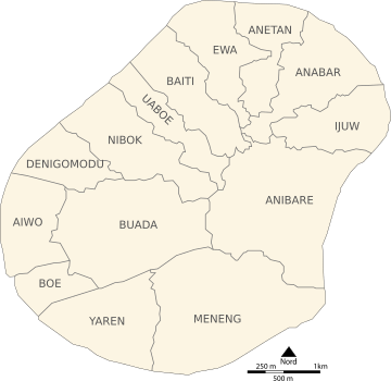
Nauru is divided into fourteen administrative districts which are grouped into eight electoral constituencies.
| Nr. | District | Former Name | Area (ha) |
Population (2005) |
No. of villages |
Density persons / ha |
|---|---|---|---|---|---|---|
| 1 | Aiwo | Aiue | 100 | 1,092 | 8 | 10.9 |
| 2 | Anabar | Anabar | 143 | 502 | 15 | 3.5 |
| 3 | Anetan | Añetañ | 100 | 516 | 12 | 5.2 |
| 4 | Anibare | Anybody | 314 | 160 | 17 | 0.5 |
| 5 | Baiti | Beidi | 123 | 572 | 15 | 4.7 |
| 6 | Boe | Boi | 66 | 795 | 4 | 12.0 |
| 7 | Buada | Buada | 266 | 716 | 14 | 2.7 |
| 8 | Denigomodu | Denikomotu | 118 | 2,827 | 17 | 24.0 |
| 9 | Ewa | Eoa | 117 | 318 | 12 | 2.7 |
| 10 | Ijuw | Ijub | 112 | 303 | 13 | 2.7 |
| 11 | Meneng | Meneñ | 288 | 1,830 | 18 | 6.4 |
| 12 | Nibok | Ennibeck | 136 | 432 | 11 | 3.2 |
| 13 | Uaboe | Ueboi | 97 | 335 | 6 | 3.5 |
| 14 | Yaren | Moqua | 150 | 820 | 7 | 5.5 |
| Nauru | Naoero | 2,130 | 11,218 | 169 | 5.3 |
Economy
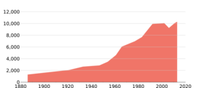
Before a resurgence in the 2010s, the Nauruan economy was strongest in the 1970s, with GDP peaking in 1981. This trend came from phosphate mining, which accounted for a majority of its economic output. Mining declined starting in the early 1980s. There are few other resources, and most necessities are imported.
There are no personal taxes in Nauru.
Demographics
Nauru is one of the most densely populated Westernized countries in the South Pacific.
The official languages of Nauru are Nauruan and English. Nauruan is a distinct Micronesian language, which is spoken by 96% of ethnic Nauruans at home. English is widely spoken and is the language of government and commerce.
The main religion practised on the island is Christianity.
Food, farming, and diet
Plants and farming
Historically, Indigenous Nauruans kept household gardens that provided much of the food that they needed through subsistence farming, with the most common food plants including coconuts, breadfruit, bananas, pandanus, papaya, and guavas. Because of the large immigrant population that would work in the phosphate mines, there were many types of fruits and vegetables grown that were staples in those countries as well. The soil in Nauru was very rich on what citizens call the "Topside", which is the raised phosphate plateau where the phosphate is mined from, and it was extremely fertile and great for growing crops. However, the area where most Nauruans live now, on the coastal ring on the island that hasn't been mined, the soil quality is among the poorest in the world, as it is shallow, alkaline, and has the coarse texture of the coral that surrounds it. In 2011, just 13% of households maintained a garden or were involved in growing crops. Most of the soil that was on Nauru is now gone because of phosphate-mining activities, leaving people to import the soil that they need. Ethnobotanical studies have indicated that the reduction in the types of plants that can be grown due to phosphate mining has significantly impacted the connection that Indigenous Nauruans feel to the land, as plants are a large part of their cultural identity and have many uses in their lives, with each plant having an average of seven uses within Pacific Island cultures.
Food
For Nauru residents today, all food must also be imported because of the loss of 90% of arable land due to phosphate mining, leaving people with a diet of mainly processed foods, such as rice and sugar. Though residents are trying to salvage the soil that they can, some researchers speculate that there will be no regeneration of soils even after the mining ceases. The country's dependence on processed and imported foods along with "cultural, historical, and social factors" have greatly affected the health of its citizens. Despite having all food imported, the Household and Income Expenditure Survey (HIES) conducted for the year of 2012–2013 found that Nauruans have a food poverty incidence rate of 0, based on the Food Poverty Line (FPL) which "includes a daily intake of 2,100 calories per adult per day."
Culture
Angam Day, held on 26 October, celebrates the recovery of the Nauruan population after the two world wars and the 1920 influenza epidemic. Colonial and contemporary Western influence has largely displaced the indigenous culture. Few older customs have been preserved, but some forms of traditional music, arts and crafts, and fishing are still practised.
Music
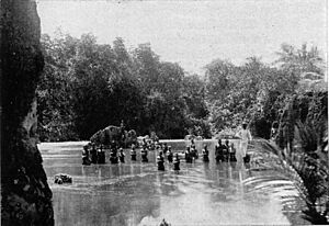
Nauruan folk songs existed as of 1970, while Oh Bwio Eben Bwio is a noticeable folk song. While the traditional culture rapidly gives way to the contemporary, as elsewhere in Micronesia, music and dance are still some of the most popular art forms. Rhythmic singing and traditional reigen are performed particularly at celebrations. At least, a historical form of a Nauruan dance called fish dance in English was recorded in a form of photographs. Known contemporary dances are the frigate bird dance and the dogoropa.
The national anthem of Nauru is "Nauru Bwiema" ("Song of Nauru"). Margaret Hendrie wrote the words; Laurence Henry Hicks composed the music.
Sport
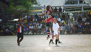
Australian rules football is the most popular sport in Nauru; it is considered the country's national team sport. There is an Australian rules football league with eight teams. Nauru has several national Australian rules teams that consistently rank among the top eight teams in the world.
Other sports popular in Nauru include weightlifting (considered a national pastime), volleyball, netball, fishing and tennis. Nauru participates in the Commonwealth Games and has participated in the Summer Olympic Games in weightlifting and judo.
Nauru's national basketball team competed at the 1969 Pacific Games, where it defeated Solomon Islands and Fiji.
Rugby union in Nauru has a growing following. The Nauru national rugby sevens team made its international debut at the 2015 Pacific Games. Nauru competed in the 2015 Oceania Sevens Championship in New Zealand.
Soccer in Nauru is a minor sport which has long been dormant in due to the popularity of Australian rules and rugby; however, a Nauru national soccer team was in formation as of 2024.
Nauru flag
Following the independence of Nauru, the flag of Nauru (Nauruan: anidenin Naoero) was raised for the first time. The flag, chosen in a local design competition, was adopted on independence day, 31 January 1968. The design symbolically depicts Nauru's geographical position, with a star just south of the Equator.
The flag reflects the geographical location of the island nation.
The narrow gold stripe with a width of 1⁄12 of the length of the flag represents the Equator. The stripe along with the star signifies the location of the island in the Pacific Ocean one degree south of the Equator. The separation of the blue flag cloth into two equal parts recalls the saga, that the first inhabitants were to have been brought to Earth from two boulders.
Nauru itself is symbolised by a white 12-pointed star. The twelve points on the star represent the island's twelve original tribes.
The blue signifies the Pacific Ocean, while the white colour of the star represents phosphate, a former major natural resource of the country.
The flag was created by a resident employed by the Australian flag manufacturer Evans. It was officially adopted on 31 January 1968. Unlike some flags of Pacific nations (e.g., that of Tuvalu), Nauru's flag has evoked little controversy.
Images for kids
-
US Army Air Force bombing the Japanese airstrip on Nauru, 1943.
-
Limestone pinnacles remain after phosphate mining at the site of one of Nauru's secondary mines
-
Australian rules football, played at Linkbelt Oval
See also
 In Spanish: Nauru para niños


