Equator facts for kids
The equator is a line which is not real drawn around a sphere or planet, such as the Earth. It is one of the lines known as a line of latitude, or circle of latitude. The name "equator" is Latin language for "even-maker"; at equator the day and night are exactly the same length around the year.
The equator is halfway between the North Pole and the South Pole. There, the surface of the planet is parallel to the axis of rotation. The equator divides the surface into the northern hemisphere and the southern hemisphere.
Contents
Overview
The latitude of the Earth's equator is, by definition, 0° (zero degrees) of arc. The Equator is one of the five notable circles of latitude on Earth; the other four are the two Polar Circles (the Arctic Circle and the Antarctic Circle) and the two Tropical Circles (the Tropic of Cancer and the Tropic of Capricorn). The Equator is the only line of latitude which is also a great circle — that is, one whose plane passes through the center of the globe. The plane of Earth's equator, when projected outwards to the celestial sphere, defines the celestial equator.
In the cycle of Earth's seasons, the plane of the equator passes through the Sun twice per year: at the March and September equinoxes. To an observer on the Earth, the Sun appears to travel North or South over the Equator (or the celestial equator) at these times. Light rays from the center of the Sun are perpendicular to the surface of the Earth at the point of solar noon on the Equator.
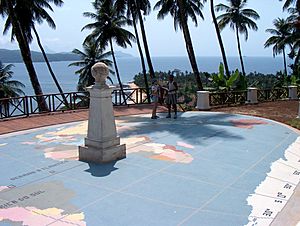
Locations on the Equator experience the quickest sunrises and sunsets, because the sun moves nearly perpendicular to the horizon for most of the year. The length of daylight (sunrise to sunset) is almost constant throughout the year; it is about 14 minutes longer than nighttime due to atmospheric refraction and the fact that sunrise is begun (or sunset is ended) as the upper edge, not the centre, of the Sun's disk crosses the horizon.
The Earth bulges slightly at the Equator; the "average" diameter of the Earth is 12,750 kilometres (7,922 mi), but the diameter at the Equator is about 43 kilometres (27 mi) greater than at the poles.
Sites near the Equator, such as the Guiana Space Centre in Kourou, French Guiana, are good locations for spaceports as they have a faster rotational speed than other latitudes; the added velocity reduces the fuel needed to launch spacecraft. Because the Earth spins to the east, spacecraft must also launch to the east (or to the southeast or northeast) to take advantage of this Earth-boost of speed.
Equatorial seasons and climate
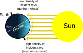
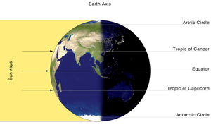
Diagram of the seasons, depicting the situation at the December solstice. Regardless of the time of day (i.e. the Earth's rotation on its axis), the North Pole will be dark, and the South Pole will be illuminated; see also arctic winter. In addition to the density of incident light, the dissipation of light in the atmosphere is greater when it falls at a shallow angle.
Seasons result from the yearly revolution of the Earth around the Sun and the tilt of the Earth's axis relative to the plane of revolution. During the year the northern and southern hemispheres are inclined toward or away from the sun according to Earth's position in its orbit. The hemisphere inclined toward the sun receives more sunlight and is in summer, while the other hemisphere receives less sun and is in winter (see solstice).
At the equinoxes, the Earth's axis is not tilted toward the sun, instead it is perpendicular to the sun meaning that the day is about 12 hours long, as is the night, across the whole of the Earth.
Near the Equator there is little temperature fluctuation throughout the year, though there may be dramatic differences in rainfall and humidity. The terms summer, autumn, winter and spring do not generally apply, and in many tropical regions people identify two seasons: the wet season and the dry season; although some areas remain wet or dry all year. Temperatures at sea level are usually high year-round, but some higher altitudes such as the Andes and Mount Kilimanjaro sustain glaciers.
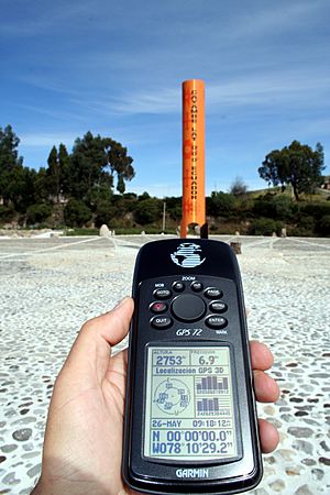
The Equator lies mostly on the three largest oceans: the Atlantic Ocean, the Indian Ocean, and the Pacific Ocean. The highest point on the Equator is at the elevation of 4,690 metres (15,387 ft), at 0°0′0″N 77°59′31″W / 0.00000°N 77.99194°W, found on the southern slopes of Volcán Cayambe [summit 5,790 metres (18,996 ft)] in Ecuador. This is slightly above the snow line and is the only place on the Equator where snow lies on the ground. At the Equator the snow line is around 1,000 metres (3,280 ft) lower than on Mount Everest and as much as 2,000 metres (6,560 ft) lower than the highest snow line in the world, near the Tropic of Capricorn on Llullaillaco.
Equatorial countries and territories
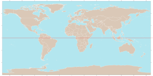
The Equator traverses the land of 11 countries. Starting at the Prime Meridian and heading eastwards, the Equator passes through:
| Co-ordinates | Country, territory or sea | Notes |
|---|---|---|
| 0°N 0°E / 0°N 0°E | Atlantic Ocean | Gulf of Guinea |
| 0°0′N 6°31′E / 0.000°N 6.517°E | Ilhéu das Rolas | |
| 0°0′N 9°21′E / 0.000°N 9.350°E | passes 8.9 km (5.5 mi) south of Ayem, 10.6 km (6.6 mi) north of Mayene, Booue | |
| 0°0′N 13°56′E / 0.000°N 13.933°E | Passing through the town of Makoua. | |
| 0°0′N 17°46′E / 0.000°N 17.767°E | Passing 9 km (5.6 mi) south of central Butembo | |
| 0°0′N 29°43′E / 0.000°N 29.717°E | Passing 32 km (20 mi) south of central Kampala | |
| 0°0′N 32°22′E / 0.000°N 32.367°E | Lake Victoria | Passing through some islands of |
| 0°0′N 34°0′E / 0.000°N 34.000°E | Passing 6 km (3.7 mi) north of central Kisumu | |
| 0°0′N 41°0′E / 0.000°N 41.000°E | ||
| 0°0′N 42°53′E / 0.000°N 42.883°E | Indian Ocean | Passing between Huvadhu Atoll and Fuvahmulah of the |
| 0°0′N 98°12′E / 0.000°N 98.200°E | The Batu Islands, Sumatra and the Lingga Islands | |
| 0°0′N 104°34′E / 0.000°N 104.567°E | Karimata Strait | |
| 0°0′N 109°9′E / 0.000°N 109.150°E | Borneo | |
| 0°0′N 117°30′E / 0.000°N 117.500°E | Makassar Strait | |
| 0°0′N 119°40′E / 0.000°N 119.667°E | Sulawesi (Celebes) | |
| 0°0′N 120°5′E / 0.000°N 120.083°E | Gulf of Tomini | |
| 0°0′N 124°0′E / 0.000°N 124.000°E | Molucca Sea | |
| 0°0′N 127°24′E / 0.000°N 127.400°E | Kayoa and Halmahera islands | |
| 0°0′N 127°53′E / 0.000°N 127.883°E | Halmahera Sea | |
| 0°0′N 129°20′E / 0.000°N 129.333°E | Gebe and Kawe islands | |
| 0°0′N 129°21′E / 0.000°N 129.350°E | Pacific Ocean | Passing between Aranuka and Nonouti atolls, |
| 0°0′N 80°6′W / 0.000°N 80.100°W | Passing 24 km (15 mi) north of central Quito, near Mitad del Mundo, and precisely at the location of Catequilla, a pre-Columbian ruin Also, Isabela Island in the Galápagos Islands |
|
| 0°0′N 75°32′W / 0.000°N 75.533°W | Passing 4.3 km (2.7 mi) north of the border with Peru | |
| 0°0′N 70°3′W / 0.000°N 70.050°W | Amazonas Roraima Pará Amapá (passing slightly south of the city center of the state capital Macapá) |
|
| 0°0′N 49°21′W / 0.000°N 49.350°W | Atlantic Ocean | At the Perigoso Canal on the mouth of the Amazon River |
Despite its name, no part of Equatorial Guinea's territory lies on the Equator. However, its island of Annobón is 155 km (96 mi) south of the Equator, and the rest of the country lies to the north.
Related pages
- Northern hemisphere
- Southern hemisphere
- Solstice and equinox
- Tropic of Cancer
- Tropic of Capricorn
- Arctic Circle
- Antarctic Circle
Images for kids
See also
 In Spanish: Ecuador terrestre para niños


