Viceroyalty of New Spain facts for kids
Quick facts for kids
Viceroyalty of New Spain
Virreynato de Nueva España
|
|||||||||||||||||
|---|---|---|---|---|---|---|---|---|---|---|---|---|---|---|---|---|---|
1521–1821 |
|||||||||||||||||

map of New Spain in red, with territories claimed but not controlled in orange.
|
|||||||||||||||||
| Capital | Mexico City | ||||||||||||||||
| Common languages | Spanish | ||||||||||||||||
| Religion | Roman Catholicism | ||||||||||||||||
| Government | Monarchy | ||||||||||||||||
| King of Spain | |||||||||||||||||
|
• 1535-1556
|
Charles I | ||||||||||||||||
|
• 1813-1821
|
Ferdinand VII | ||||||||||||||||
| Viceroy | |||||||||||||||||
|
• 1535-1550
|
Antonio de Mendoza | ||||||||||||||||
|
• 1821-1821
|
Juan O'Donojú | ||||||||||||||||
| History | |||||||||||||||||
| August 16 1521 |
|||||||||||||||||
|
• First viceking appointed
|
1521 | ||||||||||||||||
| 1810 | |||||||||||||||||
| September 28 1821 | |||||||||||||||||
| Population | |||||||||||||||||
|
• 1519
|
20.000.000 | ||||||||||||||||
|
• 1810
|
7.657.300 | ||||||||||||||||
| Currency | Peso de Oro | ||||||||||||||||
|
|||||||||||||||||
The Viceroyalty of New Spain was the name of the viceroy-ruled territories of the Spanish Empire in North America and its peripheries in Asia from 1521 to 1821. New Spain was the name that the Spanish gave to the area that today is central and southern Mexico, and since the capital city of the Viceroyalty was in Mexico City, the name was also used for the viceroyalty.
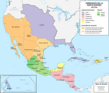
The Viceroyalty of New Spain's territory included what is the Bay Islands (until 1643), Cayman Islands (until 1670), Central America (as far as the southern border of Costa Rica until 1821), Cuba, Florida, Hispaniola (including Haiti until 1700), Jamaica (until 1670) Mariana Islands, Mexico, Philippines, Puerto Rico, nearly all of the southwestern United States (including all or parts of the modern-day U.S. states of California, Nevada, Utah, Colorado, Wyoming, Arizona, New Mexico, Texas and Florida). Spain claimed areas as far north as British Columbia and Alaska, but the northern boundary of New Spain was redefined by the Adams-Onís Treaty of 1819. New Spain also included Venezuela before it was annexed to the Viceroyalty of New Granada in 1717.
The territories were separated into provinces. Provinces were led by a governor, who was responsible for the administration of the province and often also led the province's army and militias. The provinces were grouped together under five high courts, called Audiencias in Spanish, at Santo Domingo, Mexico City, Guatemala, Guadalajara and Manila. Both the high courts and the governors had autonomy from the viceroy and carried out most duties on their own. Only on important issues did the viceroy become involved in ruling the provinces directly.
In 1821, Spain lost continental territories when it recognized the independence of Mexico, as well as Santo Domingo when it was invaded by Haiti that same year. However, Cuba, Puerto Rico and Spanish East Indies (including Mariana Islands and the Philippines) remained a part of the Spanish crown until the Spanish–American War (1898).
Related pages
Images for kids
-
An auto-da-fé in New Spain, 18th century
-
"Vázquez de Coronado Sets Out to the North" (1540), by Frederic Remington, oil on canvas, 1905
-
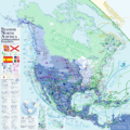
White represents the route of the Manila Galleons in the Pacific and the flota in the Atlantic; blue represents Portuguese routes.
-
José de Gálvez, 1st Marquess of Sonora, Visitador in New Spain, who initiated major reforms
-
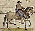
18th-century soldado de cuera in colonial Mexico
-
Bernardo de Gálvez and his army at the Siege of Pensacola in 1781.
-
On September 28, 1810, Miguel Hidalgo led the siege of the Alhóndiga de Granaditas in Guanajuato
-
View of the Plaza Mayor of Mexico City, 1695 by Cristóbal de Villalpando
-
Indian Wedding and Flying Pole, circa 1690
-
New Spain after the Adams–Onís Treaty of 1819 (not including the island territories of the Pacific Ocean).
-
18th century golden altar piece insede the Tegucigalpa cathedral.
See also
 In Spanish: Virreinato de Nueva España para niños


