Nangarhar Province facts for kids
Quick facts for kids Nangarhar (ننګرهار) |
|
| Province | |
| Country | Afghanistan |
|---|---|
| Capital | Jalalabad |
| - coordinates | 34°15′N 70°30′E / 34.25°N 70.50°E |
| Area | 7,727 km² (2,983 sq mi) |
| Population | 1,436,000 (2013) |
| Governor | Gul Agha Shirzai |
| Timezone | GMT+4:30 |
| Main language | Pashto |
Nangarhar (Pashto: ننګرهار Nangarhār) is one of the 34 provinces of Afghanistan. It is in the east of the country. Jalalabad is the capital. There are 1,383,900 people in the province.
Districts
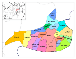
Nangarhar province is divided into 22 districts, these are:
| District | Capital | Population | Area | Notes |
|---|---|---|---|---|
| Achin | 95,468 | |||
| Bati Kot | 71,308 | |||
| Bihsud | 118,934 | Created in 2005 within Jalalabad District | ||
| Chaparhar | 57,339 | |||
| Dara-I-Nur | 28,202 | |||
| Dih Bala | 33,294 | |||
| Dur Baba | 13,479 | |||
| Goshta | 31,130 | |||
| Hisarak | 28,376 | |||
| Jalalabad | 205,423 | Sub-divided in 2005 | ||
| Kama | 52,527 | |||
| Khogyani | 111,479 | |||
| Kot | 52,154 | Created in 2005 within Rodat District | ||
| Kuz Kunar | 42,823 | |||
| Lal Pur | 18,997 | |||
| Momand Dara | 42,103 | |||
| Nazyan | 16,328 | |||
| Pachir Aw Agam | 40,141 | |||
| Rodat | 63,357 | Sub-divided in 2005 | ||
| Sherzad | 63,232 | |||
| Shinwar | 64,872 | |||
| Surkh Rod | 91,548 |
 |
Laghman Province | Kunar Province |  |
|
| Kabul Province | ||||
| Logar Province | Federally Administered Tribal Areas, |
Images for kids
-
Branches of the Kunar River meet with the Kabul River in Nangarhar
-
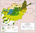
Ethnolinguistic groups in Afghanistan
See also
 In Spanish: Provincia de Nangarjar para niños

All content from Kiddle encyclopedia articles (including the article images and facts) can be freely used under Attribution-ShareAlike license, unless stated otherwise. Cite this article:
Nangarhar Province Facts for Kids. Kiddle Encyclopedia.


