Logar Province facts for kids
Quick facts for kids Logar (لوګر) |
|
| Province | |
| Country | Afghanistan |
|---|---|
| Capital | Pul-i-Alam |
| - coordinates | 34°00′N 69°12′E / 34.0°N 69.2°E |
| Area | 3,880 km² (1,498 sq mi) |
| Population | 332,451 and 550,300 (varying estimates) |
| Density | 120 /km² (311 /sq mi) |
| Timezone | UTC+4:30 |
| Main languages | Pashto Dari Persian |
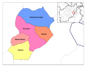
Logar (Pashto: لوګر, Persian: لوگَر) is one of the 34 provinces of Afghanistan. It is in the eastern part of the country. Most of the peoople are Pashtun.
Districts
| District | Capital | Population | Area | Notes |
|---|---|---|---|---|
| Azra | 14,550 | Shifted from Paktia Province in 2005 | ||
| Baraki Barak | 78,063 | Includes the road linking Pul-i-Alam with Highway 1 to the west | ||
| Charkh | 40,492 | Sub-divided in 2005 | ||
| Kharwar | 26,607 | Created in 2005 within Charkh District | ||
| Khoshi | 15,127 | Home to lot of the Shiite enclaves in southeast Afghanistan | ||
| Mohammad Agha | 58,979 | The northern portion of Mohammad Agha is contiguous with the southern 'suburbs' of Kabul | ||
| Pul-i-Alam | 88,886 | Includes the capital city |
 |
Kabul Province |  |
||
| Wardak Province | Nangarhar Province | |||
| Ghazni Province | Paktia Province | Federally Administered Tribal Areas, |
Images for kids
-
The main river valley in the Khoshi District of Logar province. Extensive irrigation and canal works, known as karez, provide water for the majority of the agriculture in southeastern Afghanistan.
-
Puli Alam, the capital of Logar province.
See also
 In Spanish: Provincia de Laugar para niños

All content from Kiddle encyclopedia articles (including the article images and facts) can be freely used under Attribution-ShareAlike license, unless stated otherwise. Cite this article:
Logar Province Facts for Kids. Kiddle Encyclopedia.


