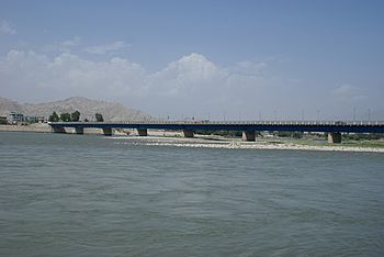
Kabul River facts for kids
Quick facts for kids Kabul |
|
|---|---|
 |
|
| Country | Afghanistan |
| City | Kabul, Surobi, Jalalabad (Afghanistan); Peshawar, Charsadda, Nowshera (Pakistan) |
| Physical characteristics | |
| Main source | Hindu Kush Mountains Maidan Wardak Province, Afghanistan 2,400 m (7,900 ft) 34°21′25″N 68°50′21″E / 34.357°N 68.8392°E |
| River mouth | Indus River Attock, Punjab, Pakistan 33°55′0″N 72°13′56″E / 33.91667°N 72.23222°E |
| Length | 700 km (430 mi) |
| Basin features | |
| Basin size | 66,000 km2 (25,000 sq mi) |
| Tributaries |
|
The Kabul River is a 700-kilometre (430 mi) long river that emerges in Maidan Wardak Province in the Sanglakh Range of the Hindu Kush mountains in Afghanistan, and is separated from the watershed (drainage basin) of the Helmand River by the Unai Pass. The Kabul River empties into the Indus River near Attock, Pakistan. It is the main river in eastern Afghanistan.
The major tributaries of the Kabul River are the Logar, Panjshir, Alingar, Surkhab, Kunar, Bara, and Swat rivers. The Kabul River later gave its name to the region and to the settlement of Kabul.
Contents
Hydrology
The Kabul River is little more than a trickle for most of the year, but swells in summer due to melting snows in the Hindu Kush Range. Its largest tributary is the Kunar River, which starts out as the Mastuj River, flowing from the Chiantar glacie in Brughil valley in Chitral, Pakistan and after flowing south into Afghanistan it is met by the Bashgal river flowing from Nurestan.
The Kunar meets the Kabul near Jalalabad. In spite of the Kunar carrying more water than the Kabul, the river continues as the Kabul River after this confluence, mainly for the political and historical significance of the name.
The Kabul River is impounded by several dams. The Naghlu, Surobi, and Darunta dams are located in the Kabul and Nangarhar provinces of Afghanistan. The Warsak Dam is in the Valley of Peshawar in Pakistan, approximately 20 km northwest of the city of Peshawar.
Other pages
Images for kids
-
One of five bridges that crossed Kabul River during the Second Anglo-Afghan War (1879-1880) era. Soldiers a pictured atop the bridge while people walk along the road in the distance and in the right foreground people sit or squat on the bridge while soldiers ride behind them. Bala Hissar (High Fort) is in the background just visible through the heat haze and trees. It was the locus of power in Kabul for many centuries and the site of fierce fighting during the war. It was partly destroyed in October–December 1879 when Sir Frederick Roberts occupied the city at the head of the Kabul Field Force
-
Kabul River valley
-
Buddhist caves, which have been carved into a set of cliffs on the north side of the Kabul river
See also
 In Spanish: Río Kabul para niños


