Eastern Development Region, Nepal facts for kids
Quick facts for kids Eastern Development Region (पुर्वाञ्चल - Purvāñcala) |
|
| Region | |
|
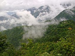
Dhankuta in rainy season
|
|
| Country | |
|---|---|
| Zones | Kosi, Mechi, Sagarmatha |
| Headquarters | Dhankuta |
| Highest point | Mount Everest |
| - elevation | 8,848 m (29,029 ft) |
| - coordinates | 27°59′17″N 86°55′31″E / 27.98806°N 86.92528°E |
| Lowest point | Kechana Kalan |
| - elevation | 60 m (197 ft) |
| - coordinates | 26°22′05″N 88°00′46″E / 26.36806°N 88.01278°E |
| Area | 28,456 km² (10,987 sq mi) |
| Population | 5,811,555 (2011) |
| Density | 204 /km² (528 /sq mi) |
| Timezone | NPT (UTC+5:45) |
| ISO 3166-2 | NP-4 |
Eastern Development Region (Nepali:पुर्वाञ्चल विकास क्षेत्र) is one of Nepal's five development regions. It is at the eastern end of the country with headquarters at Dhankuta.
Geography
The Eastern Development Region has Sikkim and West Bengal (India) to the east, Bihar (India) to the south, the Central Development Region to the west and the Tibet Autonomous Region (People's Republic of China) to the north.
It is the third largest Development Region of Nepal with an area of 28,456 km2 (10,987 sq mi) but the second in population with 5,811,555 (21.9% of total) people living there; its population density is 204.2 persons/km2.
The region has three ecological zones: the high mountains, the hills and the Terai.
The highest mountain in the region, and in the world, is Mount Everest; it is in the Solukhumbu District, Sagarmatha Zone. The lowest point of Nepal, Kechana Kalan is also here, in the Jhapa district; it is near the Mechi river and close to the border with India.
The most important rivers in the Eastern Development Region are the Kosi (also spelled Kosi), tributary of the Ganges river; and the Mechi, tributary of the Mahananda River. Nepal's largest river system (the Kosi) and its highest waterfall (the Hyatrung in the Terhathum district) are found in this region. The Hyatrung waterfall (27°14′17″N 87°33′46″E / 27.23806°N 87.56278°E) is 365 m (1,198 ft) high.
It is rich in biodiversity, with for example 28 species of Rhododendron (out of the 31 species available in Nepal) found in the Tinjure-Milke-Jaljale area.
Cities
The major cities of this region are Biratnagar, Dharan, Dhankuta, Itahari, Rajbiraj, Birtamod Urlabari and Damak. Other notable places are Namche Bazaar (the town near the base camp of Mt. Everest), Gaighat, Lahan, Ilam, etc.
Administrative subdivisions
The Eastern Development Region has 3 Zones, parallel to each other, with a total of 16 Districts, 893 Village Development Committees (VDCs), 1 Sub-metropolitan city, and 13 Municipalities; the zones and districts are:
| Zone | Population (2011) |
Area (km²) |
Pop. density (inh/km²) |
Districts | |
|---|---|---|---|---|---|
| Number | Names | ||||
| Kosi | 2,335,047 | 9,669 | 241.5 | 6 | Bhojpur, Dhankuta, Morang, Sankhuwasabha, Sunsari, Terhathum |
| Mechi | 1,422,182 | 8,196 | 173.5 | 4 | Ilam, Jhapa, Panchthar, Taplejung |
| Sagarmatha | 2,054,326 | 10,591 | 194.0 | 6 | Khotang, Okhaldhunga, Saptari, Siraha, Solukhumbu, Udayapur |
| Total | 5,811,555 | 28,456 | 204.2 | 16 | |
Related pages


