Dorchester County, South Carolina facts for kids
Quick facts for kids
Dorchester County
|
|||||
|---|---|---|---|---|---|

|
|||||
|
|||||

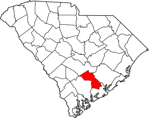
Location within the U.S. state of South Carolina
|
|||||
 South Carolina's location within the U.S. |
|||||
| Country | |||||
| State | |||||
| Founded | February 25, 1897 | ||||
| Named for | Dorchester, Massachusetts | ||||
| Seat | St. George | ||||
| Largest community | North Charleston | ||||
| Area | |||||
| • Total | 571.18 sq mi (1,479.3 km2) | ||||
| • Land | 568.59 sq mi (1,472.6 km2) | ||||
| • Water | 2.59 sq mi (6.7 km2) 0.45% | ||||
| Population
(2020)
|
|||||
| • Total | 161,540 | ||||
| • Estimate
(2023)
|
169,833 | ||||
| • Density | 284.11/sq mi (109.70/km2) | ||||
| Time zone | UTC−5 (Eastern) | ||||
| • Summer (DST) | UTC−4 (EDT) | ||||
| Congressional districts | 1st, 6th | ||||
Dorchester County is located in the U.S. state of South Carolina. As of the 2020 census, the population was 161,540. Its county seat is St. George. The county was created on February 25, 1897 by an act of the South Carolina General Assembly.
Dorchester County is included in the Charleston-North Charleston, SC Metropolitan Statistical Area. It is in the Lowcountry region of South Carolina.
Contents
History
Dorchester County is named for its first settlement area, which was established by Congregationalists in 1696. These settlers applied the name "Dorchester" after their last residence in Dorchester, Massachusetts.
Dorchester was not established as a separate county until 1897. However, when it was separately established, it came from parts of the neighboring Colleton and Berkeley counties.
Geography
According to the U.S. Census Bureau, the county has a total area of 571.18 square miles (1,479.3 km2), of which 568.59 square miles (1,472.6 km2) is land and 2.59 square miles (6.7 km2) (0.45%) is water.
State and local protected areas/sites
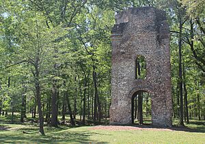
- Colonial Dorchester State Historic Site
- Edisto River Wildlife Management Area
- Givhans Ferry State Park (part)
- Middleton Place
Major water bodies
- Ashley River
- Four Hole Swamp
- Edisto River
Adjacent counties
- Bamberg County – west
- Berkeley County – east
- Charleston County – southeast
- Colleton County – southwest
- Orangeburg County – northwest
Major highways
 I-26
I-26 I-95
I-95 US 15
US 15 US 17
US 17
 US 17 Alt.
- Invalid type: US-Alt-Truck
 US 78
US 78 US 178
 SC 27
SC 27 SC 61
SC 61


 SC 61 Conn.
 SC 165
 SC 453
 SC 642
Major infrastructure
- Summerville Airport
Demographics
| Historical population | |||
|---|---|---|---|
| Census | Pop. | %± | |
| 1900 | 16,294 | — | |
| 1910 | 17,891 | 9.8% | |
| 1920 | 19,459 | 8.8% | |
| 1930 | 18,956 | −2.6% | |
| 1940 | 19,928 | 5.1% | |
| 1950 | 22,601 | 13.4% | |
| 1960 | 24,383 | 7.9% | |
| 1970 | 32,276 | 32.4% | |
| 1980 | 58,761 | 82.1% | |
| 1990 | 83,060 | 41.4% | |
| 2000 | 96,413 | 16.1% | |
| 2010 | 136,555 | 41.6% | |
| 2020 | 161,540 | 18.3% | |
| 2023 (est.) | 169,833 | 24.4% | |
| U.S. Decennial Census 1790–1960 1900–1990 1990–2000 2010 2020 |
|||
2020 census
| Race | Num. | Perc. |
|---|---|---|
| White (non-Hispanic) | 99,145 | 61.37% |
| Black or African American (non-Hispanic) | 38,278 | 23.7% |
| Native American | 886 | 0.55% |
| Asian | 3,286 | 2.03% |
| Pacific Islander | 199 | 0.12% |
| Other/Mixed | 8,885 | 5.5% |
| Hispanic or Latino | 10,861 | 6.72% |
As of the 2020 census, there were 161,540 people, 57,768 households, and 41,473 families residing in the county.
2010 census
At the 2010 census, there were 136,555 people, 50,259 households, and 36,850 families living in the county. The population density was 238.2 inhabitants per square mile (92.0/km2). There were 55,186 housing units at an average density of 96.3 units per square mile (37.2 units/km2). The racial makeup of the county was 67.8% white, 25.8% black or African American, 1.5% Asian, 0.7% American Indian, 0.1% Pacific islander, 1.4% from other races, and 2.6% from two or more races. Those of Hispanic or Latino origin made up 4.4% of the population. In terms of ancestry,
Of the 50,259 households, 40.3% had children under the age of 18 living with them, 52.6% were married couples living together, 16.0% had a female householder with no husband present, 26.7% were non-families, and 21.6% of households were made up of individuals. The average household size was 2.68 and the average family size was 3.11. The median age was 35.6 years.
The median household income was $55,034 and the median family income was $63,847. Males had a median income of $45,659 versus $32,221 for females. The per capita income for the county was $24,497. About 9.0% of families and 11.2% of the population were below the poverty line, including 16.4% of those under age 18 and 9.1% of those age 65 or over.
Economy
In 2022, the GDP of Dorchester County was $5.3 billion (about $30,938 per capita). The real GDP was $4.5 billion ($26,635 per capita) in chained 2017 dollars. Between 2022-2023, the unemployment rate has fluctuated between 2.6-2.9%.
As of April 2024[update], some of the largest employers in the county include Bosch, Food Lion, Harris Teeter, KION Group, Publix, the town of Summerville, and Walmart.
| Industry | Employment Counts | Employment Percentage (%) | Average Annual Wage ($) |
|---|---|---|---|
| Accommodation and Food Services | 4,273 | 10.9 | 21,840 |
| Administrative and Support and Waste Management and Remediation Services | 2,204 | 5.6 | 47,216 |
| Agriculture, Forestry, Fishing and Hunting | 125 | 0.3 | 94,068 |
| Arts, Entertainment, and Recreation | 738 | 1.9 | 22,412 |
| Construction | 2,235 | 5.7 | 61,412 |
| Educational Services | 3,713 | 9.4 | 49,816 |
| Finance and Insurance | 651 | 1.7 | 71,136 |
| Health Care and Social Assistance | 3,523 | 9.0 | 50,024 |
| Information | 354 | 0.9 | 77,948 |
| Management of Companies and Enterprises | 139 | 0.4 | 79,664 |
| Manufacturing | 6,148 | 15.6 | 70,668 |
| Mining, Quarrying, and Oil and Gas Extraction | 31 | 0.1 | 73,892 |
| Other Services (except Public Administration) | 1,262 | 3.2 | 37,752 |
| Professional, Scientific, and Technical Services | 1,432 | 3.6 | 70,304 |
| Public Administration | 2,548 | 6.5 | 54,964 |
| Real Estate and Rental and Leasing | 618 | 1.6 | 60,632 |
| Retail Trade | 5,261 | 13.4 | 32,396 |
| Transportation and Warehousing | 2,708 | 6.9 | 46,384 |
| Utilities | 134 | 0.3 | 77,064 |
| Wholesale Trade | 1,264 | 3.2 | 84,084 |
| Total | 39,361 | 100.0% | 50,415 |
Education
School districts include:
- Dorchester School District 2
- Dorchester School District 4
- Districts 1 and 3 merged and created District 4 in 1987.
Communities
City
- North Charleston (largest community; partly in Berkeley and Charleston counties)
Town
- Harleyville
- Lincolnville (mostly in Charleston County)
- Reevesville
- Ridgeville
- St. George (county seat)
- Summerville (partly in Berkeley and Charleston counties)
Census-designated place
- Ladson (partly in Berkeley County and Charleston County)
Unincorporated communities
- Grover
- Byrds
- Knightsville
Ghost town
See also
 In Spanish: Condado de Dorchester (Carolina del Sur) para niños


