Benin facts for kids
Quick facts for kids
Republic of Benin
République du Bénin (French)
|
|
|---|---|
|
Motto:
Fraternity, Justice, Labour
|
|
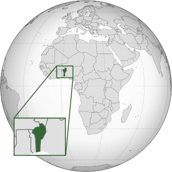
Location of Benin (dark green)
|
|
| Capital | Porto-Novo |
| Largest city | Cotonou |
| Official languages | French |
| National languages | |
| Ethnic groups
(2020)
|
|
| Religion
(2020)
|
|
| Demonym(s) |
|
| Government | Unitary presidential republic |
| Patrice Talon | |
| Mariam Chabi Talata | |
| Legislature | National Assembly |
| Independence
from France
|
|
|
• Republic of Dahomey established
|
11 December 1958 |
|
• Independence
|
1 August 1960 |
| Area | |
|
• Total
|
114,763 km2 (44,310 sq mi) (100th) |
|
• Water (%)
|
0.4% |
| Population | |
|
• 2022 estimate
|
13,754,688 (77th) |
|
• Density
|
94.8/km2 (245.5/sq mi) |
| GDP (PPP) | 2023 estimate |
|
• Total
|
|
|
• Per capita
|
|
| GDP (nominal) | 2023 estimate |
|
• Total
|
|
|
• Per capita
|
|
| Gini (2021) | ▼ 34.4 medium |
| HDI (2022) | low · 173rd |
| Currency | West African CFA franc (XOF) |
| Time zone | UTC+1 (WAT) |
| Date format | dd/mm/yyyy |
| Driving side | right |
| Calling code | +229 |
| ISO 3166 code | BJ |
| Internet TLD | .bj |
|
|
Benin (officially called the Republic of Benin) is a country in Africa. The capital of Benin is Porto-Novo. The seat of government is in Cotonou, the country's largest city. Most people live on the small southern coastline on the Bight of Benin.
The official language of Benin is French. Languages such as Fon and Yoruba are commonly spoken. The largest religious group in Benin is Roman Catholicism. This is followed closely by Islam, Vodun, and Protestantism.
Benin is a member of the United Nations, the African Union, the Organisation of Islamic Cooperation, South Atlantic Peace and Cooperation Zone, La Francophonie, the Community of Sahel-Saharan States, the African Petroleum Producers Association and the Niger Basin Authority.
Contents
History
Prior to 1600, present-day Benin comprised a variety of areas with different political systems and ethnicities. These included city-states along the coast (primarily of the Aja ethnic group, and also including Yoruba and Gbe peoples) and tribal regions inland (composed of Bariba, Mahi, Gedevi, and Kabye peoples). The Oyo Empire, located primarily to the east of Benin, was a military force in the region, conducting raids and exacting tribute from the coastal kingdoms and tribal regions.
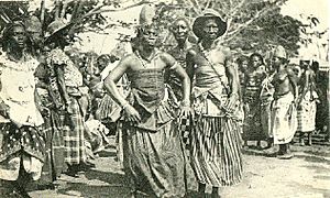
From the 17th to the 19th century, Benin was ruled by the Kingdom of Dahomey. It was called the Slave Coast from as early as the 17th century. This is because of the large number of slaves shipped to the New World. After slavery ended, France took over the country. They renamed it French Dahomey. In 1960, Dahomey gained full independence from France.
From 1972 to 1990 a Marxist–Leninist state called the People's Republic of Benin existed. The current Republic of Benin was formed in 1991.
Geography
The north–south strip of land in West Africa lies between latitudes 6° and 13°N, and longitudes 0° and 4°E. It is bounded by Togo to the west, Burkina Faso and Niger to the north, Nigeria to the east, and the Bight of Benin to the south. The distance from the Niger River in the north to the Atlantic Ocean in the south is about 650 km (404 mi). Although the coastline measures 121 km (75 mi), the country measures about 325 km (202 mi) at its widest point. Four terrestrial ecoregions lie within Benin's borders: Eastern Guinean forests, Nigerian lowland forests, Guinean forest-savanna mosaic, and West Sudanian savanna. It had a 2018 Forest Landscape Integrity Index mean score of 5.86/10, ranking it 93rd globally out of 172 countries.
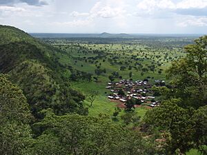
Benin shows some variation in elevation and can be divided into 4 areas from the south to the north, starting with the lower-lying, sandy, coastal plain (highest elevation 10 m (32.8 ft)) which is, at most, 10 km (6.2 mi) wide. It is marshy and dotted with lakes and lagoons communicating with the ocean. Behind the coast lies the Guinean forest-savanna mosaic-covered plateaus of southern Benin (altitude between 20 and 200 m (66 and 656 ft)), which are split by valleys running north to south along the Couffo, Zou, and Ouémé Rivers.
This geography makes it vulnerable to climate change. With the majority of the country living near the coast in lower-lying areas sea level rise could have effects on the economy and population. Northern areas will see additional regions become deserts. An area of flatter land dotted with rocky hills whose altitude reaches 400 m (1,312 ft) extends around Nikki and Save.
A range of mountains extends along the northwest border and into Togo; these are the Atacora. The highest point, Mont Sokbaro, is at 658 m (2,159 ft). Benin has fields, mangroves, and remnants of forests. In the rest of the country, the savanna is covered with thorny scrub and dotted with baobab trees. Some forests line the banks of rivers. In the north and the northwest of Benin, the Reserve du W du Niger and Pendjari National Park has African bush elephants, lions, antelopes, hippopotamus and monkeys. Pendjari National Park together with the bordering Parks Arli and W National Park in Burkina Faso and Niger are among the strongholds of the lion in West Africa; with an estimated 246–466 lions, W-Arli-Pendjari harbors the largest remaining lion population in West Africa. Historically Benin has served as habitat for the endangered African wild dog, Lycaon pictus; this canid is thought to have been locally extinct.
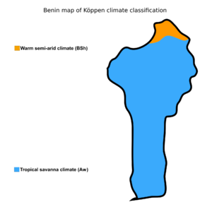
Annual rainfall in the coastal area averages 1300 mm or about 51 inches. Benin has 2 rainy and 2 dry seasons per year. The principal rainy season is from April to late July, with a shorter less intense rainy period from September to November. The main dry season is from December to April, with a cooler dry season from July to September. Temperatures and humidity are higher along the tropical coast. In Cotonou, the average maximum temperature is 31 °C (87.8 °F); the minimum is 24 °C (75.2 °F).
Variations in temperature increase when moving north through savanna and plateau toward the Sahel. A dry wind from the Sahara called the Harmattan blows from December to March, when grass dries up, other vegetation turns reddish brown, and a veil of fine dust hangs over the country, causing the skies to be "overcast". It is also the season when farmers burn brush in the fields.
Wildlife
Politics
Benin is a presidential representative democratic republic in which the President of Benin is both head of state and head of government, within a multi-party system. Executive power is exercised by the government. Legislative power is vested in the government and the legislature. The judiciary is officially independent of the executive and the legislature. The political system is derived from the 1990 Constitution of Benin and the subsequent transition to democracy in 1991.
Economy
The economy is dependent on subsistence agriculture, cotton production, and regional trade. Cotton accounts for 40% of the GDP and roughly 80% of official export receipts.
Demographics
Ethnic Groups of Benin (2013 Census) Fon (38.4%) Adja & Mina (15.1%) Yoruba (12%) Bariba (9.6%) Fula (8.6%) Ottamari (6.1%) Yoa-Lokpa (4.3%) Dendi (2.9%) Other (2.8%)
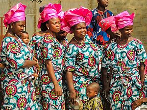
The majority of Benin's 11,485,000 inhabitants live in the south of the country. The life expectancy is 62 years. About 42 African ethnic groups live in this country, including the Yoruba in the southeast (migrated from Nigeria in the 12th century); the Dendi in the north-central area (who came from Mali in the 16th century); the Bariba and the Fula in the northeast; the Betammaribe and the Somba in the Atakora Mountains; the Fon in the area around Abomey in the South Central and the Mina, Xueda, and Aja (who came from Togo) on the coast.
Migrations have brought other African nationals to Benin that include Nigerians, Togolese, and Malians. The foreign community includes Lebanese and Indians involved in trade and commerce. The personnel of European embassies and foreign aid missions and of nongovernmental organisations and missionary groups account for a part of the 5,500 European population.
| Historical population | |||
|---|---|---|---|
| Year | 1950 | 2000 | 2018 |
| Population | 2,200,000 | 6,800,000 | 11,500,000 |
| ±% | — | +209.1% | +69.1% |
|
Largest cities or towns in Benin
According to the 2013 Census |
||
|---|---|---|
| Rank | Name | Pop. |
| 1 | Cotonou | 679,012 |
| 2 | Porto-Novo | 264,320 |
| 3 | Parakou | 255,478 |
| 4 | Godomey | 253,262 |
| 5 | Abomey-Calavi | 117,824 |
| 6 | Djougou | 94,773 |
| 7 | Bohicon | 93,744 |
| 8 | Ekpè | 75,313 |
| 9 | Abomey | 67,885 |
| 10 | Nikki | 66,109 |
Departments
Benin is divided into 12 Departments. Then it is divided into 77 communes.
Culture
Arts
Beninese literature had a strong oral tradition long before French became the main language. Felix Couchoro wrote the first Beninese novel, L'Esclave in 1929.
Singer Angélique Kidjo and actor Djimon Hounsou were both born in Cotonou, Benin. Composer Wally Badarou and singer Gnonnas Pedro are also from Benin.
Religion
Religion in Benin (2020 CIA World Factbook estimate). Christianity (52.2%) Islam (24.6%) Animist (17.6%) Others / None (5.3%)
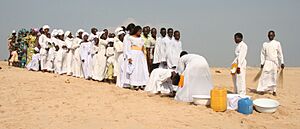
The two main religions in Benin are Christianity and Islam. In the 2013 census, 48.5% of the population of Benin were Christian (25.5% Roman Catholic, 6.7% Celestial Church of Christ, 3.4% Methodist, and 12.9% other Christian denominations), 27.7% were Muslim, 11.6% practiced Vodun, 2.6% practiced other local traditional religions, 2.6% practiced other religions, and 5.8% claimed no religious affiliation.
Traditional religions include local animistic religions in the Atakora region, and Vodun and Orisha veneration among the Yoruba and Tado peoples in the center and south of the nation. The town of Ouidah on the central coast is the spiritual center of Beninese Vodun.
Education
The literacy rate in Benin is one of the lowest in the world. In 2002 it was said to be 34.7%. At one time the education system was not free.
Culture
Language
Local languages are used as the many languages of instruction in elementary schools, with French introduced in later years. At the secondary school level, French is the sole language of instruction. Beninese languages are "generally transcribed" with a separate letter for each speech sound (phoneme), rather than using diacritics as in French or digraphs as in English.
Cuisine
The cuisine involves fresh meals served with a variety of key sauces. In southern Benin cuisine, an ingredient is corn which has been used to prepare dough which has been served with peanut- or tomato-based sauces. Fish and chicken, beef, goat, and bush rat are consumed. A staple in northern Benin is yams which has been served with sauces mentioned above. The population in the northern provinces use beef and pork meat which is fried in palm or peanut oil or cooked in sauces. Cheese is used in some dishes. Couscous, rice, and beans are eaten, along with fruits such as mangoes, oranges, avocados, bananas, kiwi fruit, and pineapples.
Meals are said to be generally light on meat and generous on vegetable fat. Frying in palm or peanut oil is a meat preparation, and smoked fish is prepared in Benin. Grinders are used to prepare corn flour, which is made into a dough and served with sauces. "Chicken on the spit" is a recipe in which chicken is roasted over a fire on wooden sticks. Palm roots are sometimes soaked in a jar with salt water and sliced garlic to tenderize them, then used in dishes. Some people have outdoor mud stoves for cooking.
Sports
The major sports in Benin are association football, basketball, golf, cycling, baseball, softball, tennis and rugby union. In the early 21st century, baseball and teqball were introduced to the country.
Images for kids
-
The Portuguese Empire was the longest European presence in Benin, beginning in 1680 and ending in 1961 when the last forces left Ajudá.
-
Yayi Boni's 2006 presidential inauguration
-
The Pendjari National Park is a reserve for the West African lion and other large animals of West Africa.
-
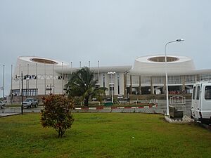
Palais Des Congres in Cotonou.
See also
 In Spanish: Benín para niños


