Stow Creek Township, New Jersey facts for kids
Quick facts for kids
Stow Creek Township, New Jersey
|
||
|---|---|---|
|
Township
|
||

Cohansey Baptist Church
|
||
|
||

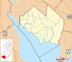
Location of Stow Creek Township in Cumberland County highlighted in red (right). Inset map: Location of Cumberland County in New Jersey highlighted in red (left).
|
||

Census Bureau map of Stow Creek Township, New Jersey
|
||
| Country | ||
| State | ||
| County | Cumberland | |
| Formed | January 19, 1748 | |
| Incorporated | February 21, 1798 | |
| Government | ||
| • Type | Township | |
| • Body | Township Committee | |
| Area | ||
| • Total | 18.89 sq mi (48.93 km2) | |
| • Land | 18.27 sq mi (47.31 km2) | |
| • Water | 0.63 sq mi (1.62 km2) 3.32% | |
| Area rank | 151st of 565 in state 10th of 14 in county |
|
| Elevation | 69 ft (21 m) | |
| Population
(2020)
|
||
| • Total | 1,312 | |
| • Estimate
(2023)
|
1,317 | |
| • Rank | 522nd of 565 in state 12th of 14 in county |
|
| • Density | 71.8/sq mi (27.7/km2) | |
| • Density rank | 549th of 565 in state 11th of 14 in county |
|
| Time zone | UTC−05:00 (Eastern (EST)) | |
| • Summer (DST) | UTC−04:00 (Eastern (EDT)) | |
| ZIP Code |
08302 – Bridgeton
|
|
| Area code(s) | 856 | |
| FIPS code | 3401171160 | |
| GNIS feature ID | 0882057 | |
| Website | ||
Stow Creek Township is a township in Cumberland County, in the U.S. state of New Jersey. It is part of the Vineland-Bridgeton metropolitan statistical area for statistical purposes. As of the 2020 United States census, the township's population was 1,312, a decrease of 119 (−8.3%) from the 2010 census count of 1,431, which in turn reflected an increase of two people (+0.1%) from the 1,429 counted in the 2000 census.
It is a dry township, where alcohol is not permitted to be sold by law.
History
Stow Creek dates back to January 19, 1748, when it was formed as one of six precincts in the newly created Cumberland County. It was formally incorporated as a township on February 21, 1798.
As part of a political battle over the site of the county seat for Cumberland County, Columbia Township was formed on March 12, 1844, from portions of Hopewell and Stow Creek Townships; the short-lived municipality included all of present-day Shiloh, in addition to extensive additional land, but all was returned to its original home when Columbia Township was dissolved on March 11, 1845, surviving as an independent municipality for a day short of one year.
The spelling of the township's name was changed from "Stoe Creek" to "Stow Creek" on October 1, 1924.
On April 9, 1929, portions of the township were taken to create Shiloh. On October 1, 1924, the New Jersey Legislature officially changed the name of the township from "Stoe Creek" to "Stow Creek", though it is unclear when "Stow" had become "Stoe".
The township's name is shared with the Stow Creek, a tributary of the Delaware River.
Geography
According to the United States Census Bureau, the township had a total area of 18.89 square miles (48.93 km2), including 18.27 square miles (47.31 km2) of land and 0.63 square miles (1.62 km2) of water (3.32%).
Unincorporated communities, localities and place names located partially or completely within the township include Arrowhead Lake, Cumberland Causeway, Garrisons Corner, Gum Tree Corner, Jericho, Kernans Corner, Macanippock, Marlboro, Roadstown, Seventh Day Mill, Stow Creek Landing, Town Hall and Willis Corner.
The township borders the municipalities of Hopewell Township, Greenwich Township and Shiloh in Cumberland County; and Alloway Township, Lower Alloways Creek Township and Quinton Township in Salem County.
Demographics
| Historical population | |||
|---|---|---|---|
| Census | Pop. | %± | |
| 1810 | 1,039 | — | |
| 1820 | 884 | −14.9% | |
| 1830 | 791 | −10.5% | |
| 1840 | 846 | 7.0% | |
| 1850 | 1,093 | 29.2% | |
| 1860 | 1,267 | 15.9% | |
| 1870 | 1,122 | −11.4% | |
| 1880 | 1,107 | −1.3% | |
| 1890 | 972 | −12.2% | |
| 1900 | 934 | −3.9% | |
| 1910 | 880 | −5.8% | |
| 1920 | 844 | −4.1% | |
| 1930 | 796 | * | −5.7% |
| 1940 | 720 | −9.5% | |
| 1950 | 957 | 32.9% | |
| 1960 | 1,010 | 5.5% | |
| 1970 | 1,050 | 4.0% | |
| 1980 | 1,365 | 30.0% | |
| 1990 | 1,437 | 5.3% | |
| 2000 | 1,429 | −0.6% | |
| 2010 | 1,431 | 0.1% | |
| 2020 | 1,312 | −8.3% | |
| 2023 (est.) | 1,317 | −8.0% | |
| Population sources: 1810–2010 1810–1920 1840 1850–1870 1850 1870 1880–1890 1890–1910 1910–1930 1940–2000 2000 2010 2020 * = Lost territory in previous decade. |
|||
2010 census
The 2010 United States census counted 1,431 people, 543 households, and 412 families in the township. The population density was 78.2 per square mile (30.2/km2). There were 568 housing units at an average density of 31.0 per square mile (12.0/km2). The racial makeup was 91.33% (1,307) White, 4.47% (64) Black or African American, 1.40% (20) Native American, 0.28% (4) Asian, 0.00% (0) Pacific Islander, 0.98% (14) from other races, and 1.54% (22) from two or more races. Hispanic or Latino of any race were 4.40% (63) of the population.
Of the 543 households, 26.2% had children under the age of 18; 61.7% were married couples living together; 8.7% had a female householder with no husband present and 24.1% were non-families. Of all households, 19.2% were made up of individuals and 9.9% had someone living alone who was 65 years of age or older. The average household size was 2.64 and the average family size was 3.01.
20.8% of the population were under the age of 18, 8.0% from 18 to 24, 21.5% from 25 to 44, 32.1% from 45 to 64, and 17.6% who were 65 years of age or older. The median age was 44.6 years. For every 100 females, the population had 101.0 males. For every 100 females ages 18 and older there were 97.9 males.
The Census Bureau's 2006–2010 American Community Survey showed that (in 2010 inflation-adjusted dollars) median household income was $71,333 (with a margin of error of +/− $7,849) and the median family income was $78,583 (+/− $7,836). Males had a median income of $52,500 (+/− $12,034) versus $38,036 (+/− $3,668) for females. The per capita income for the borough was $29,860 (+/− $3,146). About 4.1% of families and 6.8% of the population were below the poverty line, including 10.3% of those under age 18 and 4.3% of those age 65 or over.
Education
The Stow Creek School District serves public school students in kindergarten through eighth grade at Stow Creek School. As of the 2020–21 school year, the district, comprised of one school, had an enrollment of 125 students and 25.4 classroom teachers (on an FTE basis), for a student–teacher ratio of 4.9:1. In the 2016-17 school year, it had the 13th-smallest enrollment of any school district in the state. Under the Greenwich - Stow Creek Partnership established in 2009 with the Greenwich Township School District in Greenwich Township, students from both townships attend Morris Goodwin School for grades K-4 and Stow Creek School for grades 5-8.
Public school students in ninth through twelfth grades attend Cumberland Regional High School, which also serves students from Deerfield Township, Fairfield Township, Greenwich Township, Hopewell Township, Shiloh Borough and Upper Deerfield Township. As of the 2022–23 school year, the high school had an enrollment of 1,124 students and 82.0 classroom teachers (on an FTE basis), for a student–teacher ratio of 13.7:1. The high school district has a nine-member board of education, with board seats allocated to the constituent municipalities based on population, with each municipality assigned a minimum of one seat; Stow Creek Township has one seat on the board.
Students are also eligible to attend Cumberland County Technical Education Center in Vineland, serving students from the entire county in its full-time technical training programs, which are offered without charge to students who are county residents.
Transportation
As of May 2010[update], the township had a total of 44.04 miles (70.88 km) of roadways, of which 10.66 miles (17.16 km) were maintained by the municipality, 31.24 miles (50.28 km) by Cumberland County and 2.14 miles (3.44 km) by the New Jersey Department of Transportation.
New Jersey Route 49 is the main highway providing access to Stow Creek.


