Fairfield Township, Cumberland County, New Jersey facts for kids
Quick facts for kids
Fairfield Township, New Jersey
|
||
|---|---|---|
|
Township
|
||

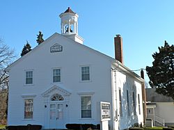
Trinity African Methodist Episcopal Church
|
||
|
||

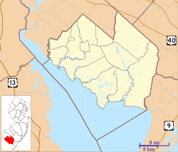
Location of Fairfield Township in Cumberland County highlighted in red (right). Inset map: Location of Cumberland County in New Jersey highlighted in red (left).
|
||

Census Bureau map of Fairfield Township, Cumberland County, New Jersey
|
||
| Country | ||
| State | ||
| County | Cumberland | |
| Formed | May 12, 1697 | |
| Incorporated | February 21, 1798 | |
| Named for | Fairfield, Connecticut | |
| Government | ||
| • Type | Township | |
| • Body | Township Committee | |
| Area | ||
| • Total | 43.82 sq mi (113.50 km2) | |
| • Land | 41.12 sq mi (106.50 km2) | |
| • Water | 2.70 sq mi (7.00 km2) 6.17% | |
| Area rank | 45th of 565 in state 5th of 14 in county |
|
| Elevation | 16 ft (5 m) | |
| Population
(2020)
|
||
| • Total | 5,546 | |
| • Estimate
(2023)
|
5,340 | |
| • Rank | 363rd of 565 in state 6th of 14 in county |
|
| • Density | 134.9/sq mi (52.1/km2) | |
| • Density rank | 528th of 565 in state 9th of 14 in county |
|
| Time zone | UTC−05:00 (Eastern (EST)) | |
| • Summer (DST) | UTC−04:00 (Eastern (EDT)) | |
| ZIP Code |
08320 – Fairton
|
|
| Area code(s) | 856 exchange: 575 | |
| FIPS code | 3401122350 | |
| GNIS feature ID | 0882059 | |
| Website | ||
Fairfield Township is a township in Cumberland County, in the U.S. state of New Jersey. It is part of the Vineland-Bridgeton metropolitan statistical area, which encompasses all of Cumberland County for statistical purposes and which constitutes a part of the Delaware Valley. As of the 2020 United States census, the township's population was 5,546, a decrease of 749 (−11.9%) from the 2010 census count of 6,295, which in turn reflected an increase of 12 (+0.2%) from the 6,283 counted in the 2000 census.
Fairfield Township was formed by Royal charter on May 12, 1697, from portions of the Cohansey Township area, while still part of Salem County, and was formed as a precinct in the newly created Cumberland County on January 19, 1748. It was incorporated on February 21, 1798, as one of the initial group of 104 townships in the state by an act of the New Jersey Legislature. Portions of the township were taken to form Downe Township (September 26, 1772), Millville Township (February 24, 1801) and Lawrence Township (February 17, 1885).
The name Fairfield refers to its original settlers, who were émigrés from Fairfield, Connecticut who settled in the area in 1697. The oldest Presbyterian church in South Jersey is said to date to June 1697. There is a plaque and an old cemetery which indicates the original log building. When it was first created as one of Cumberland County's original six townships, it included land that would later become Commercial Township, Downe Township, Lawrence Township and Millville.
Contents
Geography
According to the U.S. Census Bureau, the township had a total area of 43.82 square miles (113.50 km2), including 41.12 square miles (106.50 km2) of land and 2.70 square miles (7.00 km2) of water (6.17%).
Fairton (with a 2010 census population of 1,264,) and Gouldtown are unincorporated communities and census-designated places (CDPs) located within Fairfield Township.
Other unincorporated communities, localities and place names located partially or completely within the township include Back Neck, Ben Davis Point, Clarks Pond, Fordville, Lanings Wharf, Mulfords Landing, New England Crossroads, Sea Breeze and Tindells Landing.
The township has three primary population centers: Sea Breeze, Fairton (originally named Bumbridge) and Gouldtown, an old African American community from the segregation period.
Fairfield Township borders the Cumberland County municipalities of Bridgeton, Deerfield Township, Greenwich Township, Hopewell Township, Lawrence Township, Millville and Upper Deerfield Township, along with the Delaware Bay.
Demographics
| Historical population | |||
|---|---|---|---|
| Census | Pop. | %± | |
| 1810 | 2,279 | * | — |
| 1820 | 1,869 | −18.0% | |
| 1830 | 1,812 | −3.0% | |
| 1840 | 1,935 | 6.8% | |
| 1850 | 2,133 | 10.2% | |
| 1860 | 2,448 | 14.8% | |
| 1870 | 3,011 | 23.0% | |
| 1880 | 3,215 | 6.8% | |
| 1890 | 1,688 | * | −47.5% |
| 1900 | 1,911 | 13.2% | |
| 1910 | 1,629 | −14.8% | |
| 1920 | 1,514 | −7.1% | |
| 1930 | 1,848 | 22.1% | |
| 1940 | 1,977 | 7.0% | |
| 1950 | 2,932 | 48.3% | |
| 1960 | 3,916 | 33.6% | |
| 1970 | 4,990 | 27.4% | |
| 1980 | 5,693 | 14.1% | |
| 1990 | 5,699 | 0.1% | |
| 2000 | 6,283 | 10.2% | |
| 2010 | 6,295 | 0.2% | |
| 2020 | 5,546 | −11.9% | |
| 2023 (est.) | 5,340 | −15.2% | |
| Population sources: 1810–2000 1810–1920 1840 1850–1870 1850 1870 1880–1890 1890–1910 1910–1930 1940–2000 2000 2010 2020 * = Lost territory in previous decade |
|||
2010 census
The 2010 United States census counted 6,295 people, 1,882 households, and 1,357 families in the township. The population density was 152.6 inhabitants per square mile (58.9/km2). There were 2,058 housing units at an average density of 49.9 per square mile (19.3/km2). The racial makeup was 37.49% (2,360) White, 47.53% (2,992) Black or African American, 5.10% (321) Native American, 0.44% (28) Asian, 0.03% (2) Pacific Islander, 4.58% (288) from other races, and 4.83% (304) from two or more races. Hispanic or Latino of any race were 12.84% (808) of the population.
Of the 1,882 households, 24.6% had children under the age of 18; 43.6% were married couples living together; 21.3% had a female householder with no husband present and 27.9% were non-families. Of all households, 24.1% were made up of individuals and 9.9% had someone living alone who was 65 years of age or older. The average household size was 2.67 and the average family size was 3.14.
17.8% of the population were under the age of 18, 9.2% from 18 to 24, 32.5% from 25 to 44, 27.3% from 45 to 64, and 13.2% who were 65 years of age or older. The median age was 39.0 years. For every 100 females, the population had 139.4 males. For every 100 females ages 18 and older there were 148.8 males.
Fairfield Township had the highest percentage of Native Americans in any municipality in New Jersey, at 5.10% in the 2010 census.
The Census Bureau's 2006–2010 American Community Survey showed that (in 2010 inflation-adjusted dollars) median household income was $46,895 (with a margin of error of +/− $3,014) and the median family income was $55,286 (+/− $4,900). Males had a median income of $45,333 (+/− $4,287) versus $32,763 (+/− $2,703) for females. The per capita income for the borough was $20,619 (+/− $1,444). About 6.7% of families and 10.3% of the population were below the poverty line, including 17.1% of those under age 18 and 4.3% of those age 65 or over.
Education
The Fairfield Township School District serves public school students in pre-kindergarten through eighth grade. As of the 2022–23 school year, the district, comprised of one school, had an enrollment of 510 students and 35.0 classroom teachers (on an FTE basis), for a student–teacher ratio of 14.6:1. The district opened the new Fairfield Township School in September 2006, consolidating all grades into a single building located at 375 Gouldtown-Woodruff Road in the Gouldtown section of the township.
Public school students in ninth through twelfth grades attend Cumberland Regional High School, which also serves students from Deerfield Township, Greenwich Township, Hopewell Township, Shiloh Borough, Stow Creek Township and Upper Deerfield Township. As of the 2022–23 school year, the high school had an enrollment of 1,124 students and 82.0 classroom teachers (on an FTE basis), for a student–teacher ratio of 13.7:1. The high school district has a nine-member board of education, with board seats allocated to the constituent municipalities based on population; Fairfield Township has two seats on the board.
Students are also eligible to attend Cumberland County Technical Education Center in Vineland, serving students from the entire county in its full-time technical training programs, which are offered without charge to students who are county residents.
Transportation
Roads and highways
As of May 2010[update], the township had a total of 74.45 miles (119.82 km) of roadways, of which 30.89 miles (49.71 km) were maintained by the municipality, 39.90 miles (64.21 km) by Cumberland County and 3.66 miles (5.89 km) by the New Jersey Department of Transportation.
Route 49 is the main highway serving Fairfield Township. County Route 553 also traverses the township.
Public transportation
NJ Transit offers service on the 553 route between Upper Deerfield Township and Atlantic City.
Notable people
People who were born in, residents of, or otherwise closely associated with Fairfield Township include:
- Nathaniel Clark Burt (1825–1874), Presbyterian clergyman
- Harold Gould (1924–2012), baseball pitcher with the Philadelphia Stars in the Negro leagues from 1947 to 1948
- John T. Nixon (1820–1889), represented New Jersey's 1st congressional district in the United States House of Representatives from 1859 to 1863
- Theophilus Gould Steward (1843–1924), author, educator, and clergyman, who was a U.S. Army chaplain and Buffalo Soldier of 25th U.S. Colored Infantry


