Alloway Township, New Jersey facts for kids
Quick facts for kids
Alloway Township, New Jersey
|
||
|---|---|---|
|
Township
|
||

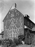
Dickenson House
|
||
|
||

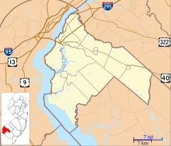
Alloway Township highlighted in Salem County. Inset map: Salem County highlighted in the State of New Jersey.
|
||

Census Bureau map of Alloway Township, New Jersey
|
||
| Country | ||
| State | ||
| County | ||
| Royal charter | June 17, 1767, as Upper Alloways Creek Township | |
| Incorporated | February 21, 1798 | |
| Renamed | February 21, 1884, as Alloway Township | |
| Named for | Native American Chief Alloway | |
| Government | ||
| • Type | Township | |
| • Body | Township Committee | |
| Area | ||
| • Total | 33.91 sq mi (87.84 km2) | |
| • Land | 33.48 sq mi (86.70 km2) | |
| • Water | 0.44 sq mi (1.13 km2) 1.29% | |
| Area rank | 71st of 565 in state 6th of 15 in county |
|
| Elevation | 62 ft (19 m) | |
| Population
(2020)
|
||
| • Total | 3,283 | |
| • Estimate
(2023)
|
3,319 | |
| • Rank | 435th of 565 in state 9th of 15 in county |
|
| • Density | 98.1/sq mi (37.9/km2) | |
| • Density rank | 542nd of 565 in state 10th of 15 in county |
|
| Time zone | UTC−05:00 (Eastern (EST)) | |
| • Summer (DST) | UTC−04:00 (Eastern (EDT)) | |
| ZIP Code |
08001
|
|
| Area codes | 856 exchanges: 339, 878, 935 | |
| FIPS code | 3403300880 | |
| GNIS feature ID | 00882131 | |
| Website | ||
Alloway Township is a township in Salem County, in the U.S. state of New Jersey. As of the 2020 United States census, the township's population was 3,283, a decrease of 184 (−5.3%) from the 2010 census count of 3,467, which in turn reflected an increase of 693 (+25.0%) from the 2,774 counted in the 2000 census.
History
What is now Alloway was formally incorporated as Upper Alloways Creek Township by a Royal charter granted on June 17, 1767, from portions of the now-defunct Alloways Creek Township. The township was formally incorporated by an act of the New Jersey Legislature on February 21, 1798. Quinton Township was formed from portions of the township on February 18, 1873. The name was officially changed to Alloway Township as of February 21, 1884.
The name Alloway is derivative of Allowas, a local Native American chief.
Ranch Hope, a nonprofit organization founded in 1962 by Reverend David L. Bailey Sr. and Eileen Bailey, provides behavioral health care, education, short-term shelter care, supportive housing and adventure-based services for thousands of children and families annually on a 100-acre (40 ha) campus in the township.
Geography
According to the United States Census Bureau, the township had a total area of 33.91 square miles (87.84 km2), including 33.48 square miles (86.70 km2) of land and 0.44 square miles (1.13 km2) of water (1.29%).
Alloway (with a 2010 Census population of 1,402) is an unincorporated community and census-designated place (CDP) located within Alloway Township. Other unincorporated communities, localities and place names located partially or completely within the township include Aldine, Alloway Junction, Dilkes Mile, Friesburg, Lake Sycamore, Mower, New Boston, Oakland, Penton, Remsterville, Riddleton and Watsons Mills.
The township borders Mannington Township, Pilesgrove Township, Quinton Township and Upper Pittsgrove Township in Salem County; and Hopewell Township, Stow Creek Township and Upper Deerfield Township in Cumberland County.
Demographics
| Historical population | |||
|---|---|---|---|
| Census | Pop. | %± | |
| 1810 | 1,921 | — | |
| 1820 | 2,194 | 14.2% | |
| 1830 | 2,136 | −2.6% | |
| 1840 | 2,235 | 4.6% | |
| 1850 | 2,530 | 13.2% | |
| 1860 | 2,899 | 14.6% | |
| 1870 | 3,062 | 5.6% | |
| 1880 | 1,917 | * | −37.4% |
| 1890 | 1,675 | −12.6% | |
| 1900 | 1,528 | −8.8% | |
| 1910 | 1,533 | 0.3% | |
| 1920 | 1,431 | −6.7% | |
| 1930 | 1,575 | 10.1% | |
| 1940 | 1,705 | 8.3% | |
| 1950 | 1,792 | 5.1% | |
| 1960 | 2,226 | 24.2% | |
| 1970 | 2,550 | 14.6% | |
| 1980 | 2,680 | 5.1% | |
| 1990 | 2,795 | 4.3% | |
| 2000 | 2,774 | −0.8% | |
| 2010 | 3,467 | 25.0% | |
| 2020 | 3,283 | −5.3% | |
| 2023 (est.) | 3,319 | −4.3% | |
| Population sources: 1810–2000 1810–1920 1840 1850–1870 1850 1870 1880–1890 1890–1910 1910–1930 1940–2000 2000 2010 2020 * = Lost territory in previous decade. |
|||
2010 census
The 2010 United States census counted 3,467 people, 1,193 households, and 945 families in the township. The population density was 103.8 inhabitants per square mile (40.1/km2). There were 1,268 housing units at an average density of 38.0 per square mile (14.7/km2). The racial makeup was 91.49% (3,172) White, 5.08% (176) Black or African American, 0.43% (15) Native American, 0.89% (31) Asian, 0.00% (0) Pacific Islander, 0.61% (21) from other races, and 1.50% (52) from two or more races. Hispanic or Latino of any race were 1.96% (68) of the population.
Of the 1,193 households, 34.5% had children under the age of 18; 67.6% were married couples living together; 6.3% had a female householder with no husband present and 20.8% were non-families. Of all households, 17.4% were made up of individuals and 8.0% had someone living alone who was 65 years of age or older. The average household size was 2.84 and the average family size was 3.21.
26.2% of the population were under the age of 18, 7.8% from 18 to 24, 23.2% from 25 to 44, 30.8% from 45 to 64, and 11.9% who were 65 years of age or older. The median age was 40.1 years. For every 100 females, the population had 101.9 males. For every 100 females ages 18 and older there were 102.5 males.
The Census Bureau's 2006–2010 American Community Survey showed that (in 2010 inflation-adjusted dollars) median household income was $86,979 (with a margin of error of +/− $8,158) and the median family income was $91,979 (+/− $8,633). Males had a median income of $61,544 (+/− $11,567) versus $35,528 (+/− $2,497) for females. The per capita income for the borough was $27,649 (+/− $2,963). About 4.6% of families and 5.6% of the population were below the poverty line, including 3.9% of those under age 18 and 19.1% of those age 65 or over.
Education
The Alloway Township School District serves students in public school for pre-kindergarten through eighth grade at Alloway Township School. As of the 2021–22 school year, the district, comprised of one school, had an enrollment of 289 students and 25.2 classroom teachers (on an FTE basis), for a student–teacher ratio of 11.5:1.
Students in public school for ninth through twelfth grades attend Woodstown High School in Woodstown, which serves students from Pilesgrove Township and Woodstown, along with students from Alloway Township, Oldmans Township and Upper Pittsgrove Township who attend the high school as part of sending/receiving relationships with the Woodstown-Pilesgrove Regional School District. As of the 2021–22 school year, the high school had an enrollment of 559 students and 49.7 classroom teachers (on an FTE basis), for a student–teacher ratio of 11.2:1.
Transportation
As of May 2010[update], the township had a total of 79.86 miles (128.52 km) of roadways, of which 36.66 miles (59.00 km) were maintained by the municipality and 43.20 miles (69.52 km) by Salem County.
New Jersey Route 77 (Pole Tavern-Bridgeton Road) passes through the far eastern corner of the township. County Route 540 and County Route 581 also traverse the township.
Notable people
Notable current and former residents of Alloway Township include:
- David Bailey, politician who represents the 3rd legislative district in the New Jersey General Assembly since January 2024


