States and union territories of India facts for kids
Quick facts for kids States and union territories of India |
|
|---|---|
| Category | Federated states |
| Location | Republic of India |
| Created by | Constitution of India |
| Created | 26 January 1950 |
| Number | 28 States 8 Union territories (as of 2024) |
| Populations | States: Sikkim – 610,577 (lowest) Uttar Pradesh – 199,812,341 (highest) Union Territories: Lakshadweep – 64,473 (lowest) Delhi – 16,787,941 (highest) |
| Areas | States: Goa – 3,702 km2 (1,429 sq mi) (smallest) Rajasthan – 342,269 km2 (132,151 sq mi) (largest) Union territories: Lakshadweep – 32 km2 (12 sq mi) (smallest) Ladakh – 59,146 km2 (22,836 sq mi) (largest) |
| Government | Government of India State governments |
| Subdivisions | Divisions Districts Tehsils |
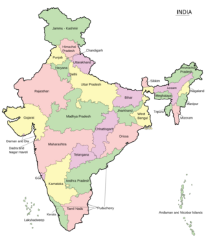
India is a federal republic comprising 28 states and 8 union territories. The states and union territories are further subdivided into districts and smaller administrative divisions.
The states are self-governing administrative divisions, each having a state government. The governing powers of the states are shared between the state government and the union government. The union territories are directly governed by the union government though some of the union territories have their own territorial government with certain autonomy.
The framework for the states and union territories were established by the Constitution of India, which came into effect on 26 January 1950. As per the Indian Constitution, the power to demarcate states and union territories in India is solely reserved with the Parliament of India, which can form new states/union territories, separate/merge territories from/to an existing state or convert states to union territories or vice versa.
Contents
History
British Raj: before 1947
After the Indian Rebellion of 1857, the British Crown took over the administration of India from the rule of the British East India Company through the Government of India Act 1858. During the British Raj, India was a complex political entity consisting of various imperial divisions and states and territories of varying autonomy. It was made up of two types of territory: British India and native Princely States. Apart from the provinces directly ruled territories of the Crown, there were 584 constituent states with suzerainty over 175 princely states was exercised by the central government of British India under the viceroy in the name of the British Crown and the remaining states were dependents of the provincial governments of British India under a governor, lieutenant-governor, or chief commissioner. In 1907, there were seven major and three minor provinces within the boundaries of present-day India, which were ruled by a Governor, Lieutenant-Governor or a Chief Commissioner on behalf of the Emperor of India.
| Province | Area (km2) | Population in million (1901) | Chief Administrator | Map |
|---|---|---|---|---|
| Major Provinces | 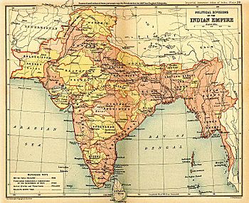 |
|||
| Assam Province | 130000 | 6 | Chief Commissioner | |
| Bengal Presidency | 390000 | 75 | Lieutenant-Governor | |
| Bombay Presidency | 320000 | 19 | Governor-in-Council | |
| Central Provinces and Berar | 270000 | 13 | Chief Commissioner | |
| Madras Presidency | 370000 | 38 | Governor-in-Council | |
| Punjab | 250000 | 20 | Lieutenant-Governor | |
| United Provinces | 280000 | 48 | Lieutenant-Governor | |
| Minor Provinces | ||||
| Ajmer-Merwara | 7000 | 477 | ex officio Chief Commissioner | |
| Andaman and Nicobar Islands | 78000 | 25 | Chief Commissioner | |
| Coorg Province | 4100 | 181 | ex officio Chief Commissioner | |
In addition, there were two semi-autonomous imperial structures called agencies, Rajputana and Central India, which had an Agent to the Governor-General (AGG) functioning as the Emperor's representative to all the states in the agency. The states of Baroda, Kashmir and Jammu, Nizamate of Hyderabad and Kingdom of Mysore were neither part of a province nor an agency and had direct relations with the Crown through the Governor General of India. In 1911, the capital of India was shifted from Calcutta to Delhi, which resulted in the creation of a special province of Delhi from the existing Punjab province, administered by a special commissioner. In March 1912, Bihar and Orissa was split as a new province from Bengal.
In 1919, the fourth Government of India was enacted by the British Parliament. The act introduced provision for majority of the members to the legislatures of the provinces to be democratically elected. All provinces were elevated to governorship and there were eight governor's provinces apart from the three chief commissioner's provinces of Ajmer-Merwara, Coorg and Delhi. The Chamber of Princes was established by Emperor George V in 1920 as a consequence of the act, thus creating more agencies with representative members who could voice out their opinions to the Viceroy of India directly. Additional imperial agencies were established in the subsequent years: Punjab States, Madras States, Deccan States Agency and Kolhapur Residency, Western India and Gujarat States Agency and Baroda Residency, Eastern States and Gwalior Residency.
In 1935, the British Parliament enacted the Government of India Act which granted more autonomy to the Indian provinces. The act introduced provisions for the provincial legislatures to propagate its own laws in certain subjects without the ascent of the governor-general. The act also created the office of a Premier in each province who functioned as the new head of government and was responsible to the provincial legislature. Bengal, Madras and Bombay presidencies were officially styled as provinces and new provinces of Orissa and Sind were created from Bihar and Bombay respectively.
After Independence: 1947–50
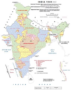
After the Indian Independence Act in 1947, the Indian Empire was dissolved along with the Imperial Legislative Council and the Chamber of Princes and the Union of India was consequently established when the provinces of erstwhile British Raj and princely states were integrated into the Indian Union. The old provinces largely remained the same with the princely states who acceded mostly absorbed into the existing provinces of the union while a few were organized into separate provinces. In 1950, after the adoption of the Constitution of India, these became part of the Republic of India with the constitution classifying the states into four categories.
| Classification | Description | Count | Constituents |
|---|---|---|---|
| Part A | Former governors' provinces ruled by a governor and elected state legislature | 9 | Assam (Assam Province), Bihar (Bihar Province), Bombay (Bombay Province), East Punjab (Punjab Province), Madhya Pradesh (Central Provinces and Berar), Madras (Madras Province), Orissa (Orissa Province), Uttar Pradesh (United Provinces), West Bengal (Bengal Province) |
| Part B | Former princely state(s) governed by a rajpramukh, appointed by the President of India and an elected legislature | 8 | Hyderabad (Hyderabad State), Jammu and Kashmir (Jammu and Kashmir Princely State), Madhya Bharat (Central India Agency), Mysore (Mysore Princely State), Patiala and East Punjab States Union, Rajasthan (Rajputana Agency), Saurashtra (Baroda, Western India and Gujarat States Agency), Travancore–Cochin (Travancore Princely State and Cochin Princely State) |
| Part C | Former chief commissioners' provinces and some princely states, governed by a chief commissioner appointed by the President of India | 10 | Ajmer (Ajmer-Merwara Province, Bhopal (Bhopal Princely State), Bilaspur (Bilaspur Princely State), Coorg (Coorg Province), Delhi, Himachal Pradesh, Kutch (Cutch Princely State), Manipur (Manipur Princely State), Tripura (Tripura Princely State), Vindhya Pradesh (Central India Agency) |
| Part D | Administered by a lieutenant governor appointed by the union government | 1 | Andaman and Nicobar Islands |
Republic and states re-organization: 1950–59
On 1 July 1954, Bilaspur was merged with Himachal Pradesh and Chandernagore, a former enclave of French India was incorporated into West Bengal in 1955. In 1953, Andhra state was created from the northern districts of Madras state, following the Andhra movement demanding a separate state for the Telugus. In July 1954, Portuguese exclave of Dadra and Nagar Haveli was taken over by pro-India forces and became the Free Dadra and Nagar Haveli state. In November 1954, the French enclaves of Pondichéry, Karikal, Yanaon and Mahé were transferred to India.
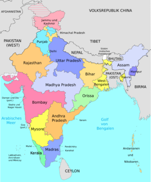
In 1956, the States Reorganisation Act was passed, which re-organized the country into 14 states and six union territories. As a result of the act:
- Andhra Pradesh was created with the merger of Andhra state with the Telugu-speaking districts of Hyderabad State
- Kerala was created by merging Malabar district and Kasaragod taluk of South Canara district of Madras state with Travancore–Cochin; Kanyakumari district and Sengottai taluk were added to Madras State from Travancore–Cochin. The Laccadive Islands, Aminidivi Islands and Minicoy Island, which had been divided between the South Canara and Malabar districts were organized into a union territory
- Mysore State was re-organized with the addition of Bellary and South Canara districts (excluding Kasaragod taluk) and Kollegal taluk of Coimbatore district from the Madras State, Belgaum, Bijapur, North Canara and Dharwad districts from Bombay State, the Kannada-majority districts of Bidar, Raichur and Kalaburagi from Hyderabad state and the Coorg state.
- Bombay State was enlarged by the addition of Saurashtra and Kutch State, the Marathi-speaking districts of Nagpur division of Madhya Pradesh and the Marathwada region of Hyderabad state .
- Rajasthan and Punjab gained territories from Ajmer state and PEPSU respectively and certain territories of Bihar were transferred to West Bengal.
- No changes in boundaries of Assam, Jammu and Kashmir, Orissa and Uttar Pradesh.
- Part C and Part D territories that were not merged into other states were organized into the six union territories of Andaman and Nicobar Islands, Delhi, Manipur, Tripura, Himachal Pradesh and Laccadive, Minicoy & Amindivi Islands.
Later years: 1960–present
Following the Mahagujarat movement, Bombay state was split into Gujarat and Maharashtra on 1 May 1960 by the Bombay Reorganisation Act. Goa, Daman and Diu was established as a union territory, following the liberation of Goa and Daman and Diu and from Portuguese and accession of Daman and Diu in 1961. Pondicherry was formed as a union territory following the de-jure transfer of French enclaves in India in 1962. On 1 December 1963, Nagaland was divided as a new state from Assam. The Punjabi Suba movement, which sought a separate Punjabi-speaking state, resulted in the Punjab Reorganisation Act of 1966, which created the state of Haryana and the union territory of Chandigarh with the transfer of the northern districts of Punjab to Himachal Pradesh.
Madras state was renamed as Tamil Nadu in 1969. Himachal Pradesh was elevated to statehood in 1970. The north-eastern states of Manipur, Meghalaya and Tripura were established in January 1972. Mysore State was renamed Karnataka in 1973. On 26 April 1975, Sikkim became the 22nd state after the 1975 Sikkimese monarchy referendum which resulted in the Kingdom of Sikkim acceding to India. In February 1987, Arunachal Pradesh and Mizoram were established as new states. In May 1987, Goa achieved statehood with the northern exclaves of Daman and Diu becoming a separate union territory.
In 2000, three new states were created: Chhattisgarh from eastern Madhya Pradesh, Uttaranchal from north-western Uttar Pradesh and Jharkhand from southern Bihar with the enactment of Madhya Pradesh Reorganisation Act, 2000, Uttar Pradesh Reorganisation Act, 2000 and Bihar Reorganisation Act, 2000 respectively. In 2006, Pondicherry was renamed as Puducherry and Uttaranchal became Uttarakhand followed by Orissa being renamed as Odisha in 2011. In June 2014, Telangana was separated from Andhra Pradesh as the 29th state of the union, through the Andhra Pradesh Reorganisation Act, 2014, following the Telangana movement. On 31 October 2019, the state of Jammu and Kashmir was split into two new union territories of Jammu and Kashmir and Ladakh as a result of the Jammu and Kashmir Reorganisation Act, 2019. On 26 January 2020, the Union Territory of Daman and Diu and the Union Territory of Dadra and Nagar Haveli were merged into a single union territory of Union Territory of Dadra and Nagar Haveli and Daman and Diu.
Current proposals
Powers and functions
The framework for the states and union territories were established by the Constitution of India, which came into effect on 26 January 1950. As per the Indian Constitution, the power to demarcate states and union territories in India is solely reserved with the Parliament of India, which can form new states/union territories, separate/merge territories from/to an existing state or convert states to union territories or vice versa. The constitution distributes the sovereign executive and legislative powers exercisable with respect to the territory of any state between the union government and that of the state. Article 73 states that the executive power of the union government shall extend to the matters with respect to which parliament has power to make laws even if it affects the states while Article 162 defines that the executive power of a state shall extend to the matters with respect to which the state legislature has power to make laws. The union territories are directly governed by the union government though some of the union territories have their own territorial government with certain autonomy.
States and union territories
States
| State | ISO | Vehicle code |
Zone | Capital | Largest city | Established | Population (2011) |
Area (km2) |
Official languages |
Additional official languages |
|---|---|---|---|---|---|---|---|---|---|---|
| Andhra Pradesh | IN-AP | AP | Southern | Amaravati | Visakhapatnam | 1 November 1956 | 49,506,799 | 162,975 | Telugu | Urdu |
| Arunachal Pradesh | IN-AR | AR | North-Eastern | Itanagar | 20 February 1987 | 1,383,727 | 83,743 | English | — | |
| Assam | IN-AS | AS | North-Eastern | Dispur | Guwahati | 26 January 1950 | 31,205,576 | 78,438 | Assamese, Boro | Bengali |
| Bihar | IN-BR | BR | Eastern | Patna | 26 January 1950 | 104,099,452 | 94,163 | Hindi | Urdu | |
| Chhattisgarh | IN-CG | CG | Central | Raipur | 1 November 2000 | 25,545,198 | 135,194 | Hindi | Chhattisgarhi | |
| Goa | IN-GA | GA | Western | Panaji | Vasco da Gama | 30 May 1987 | 1,458,545 | 3,702 | Konkani | Marathi |
| Gujarat | IN-GJ | GJ | Western | Gandhinagar | Ahmedabad | 1 May 1960 | 60,439,692 | 196,024 | Gujarati, Hindi | — |
| Haryana | IN-HR | HR | Northern | Chandigarh | Faridabad | 1 November 1966 | 25,351,462 | 44,212 | Hindi | English, Punjabi |
| Himachal Pradesh | IN-HP | HP | Northern | Shimla (Summer) Dharamshala (Winter) |
Shimla | 25 January 1971 | 6,864,602 | 55,673 | Hindi | Sanskrit |
| Jharkhand | IN-JH | JH | Eastern | Ranchi | Jamshedpur | 15 November 2000 | 32,988,134 | 79,714 | Hindi | 16 languages |
| Karnataka | IN-KA | KA | Southern | Bangalore | 1 November 1956 | 61,095,297 | 191,791 | Kannada | — | |
| Kerala | IN-KL | KL | Southern | Thiruvananthapuram | 1 November 1956 | 33,406,061 | 38,863 | Malayalam | English | |
| Madhya Pradesh | IN-MP | MP | Central | Bhopal | Indore | 1 November 1956 | 72,626,809 | 308,252 | Hindi | — |
| Maharashtra | IN-MH | MH | Western | Mumbai (Summer) Nagpur (Winter) |
Mumbai | 1 May 1960 | 112,374,333 | 307,713 | Marathi | — |
| Manipur | IN-MN | MN | North-Eastern | Imphal | 21 January 1972 | 2,855,794 | 22,327 | Manipuri | English | |
| Meghalaya | IN-ML | ML | North-Eastern | Shillong | 21 January 1972 | 2,966,889 | 22,429 | English | — | |
| Mizoram | IN-MZ | MZ | North-Eastern | Aizawl | 20 February 1987 | 1,097,206 | 21,081 | Mizo, English, Hindi | — | |
| Nagaland | IN-NL | NL | North-Eastern | Kohima | Dimapur | 1 December 1963 | 1,978,502 | 16,579 | English | — |
| Odisha | IN-OD | OD | Eastern | Bhubaneswar | 26 January 1950 | 41,974,218 | 155,707 | Odia | — | |
| Punjab | IN-PB | PB | Northern | Chandigarh | Ludhiana | 1 November 1966 | 27,743,338 | 50,362 | Punjabi | — |
| Rajasthan | IN-RJ | RJ | Northern | Jaipur | 26 January 1950 | 68,548,437 | 342,239 | Hindi | English | |
| Sikkim | IN-SK | SK | North-Eastern | Gangtok | 16 May 1975 | 610,577 | 7,096 | Nepali, Sikkimese, Lepcha, English | 8 languages | |
| Tamil Nadu | IN-TN | TN | Southern | Chennai | 1 November 1956 | 72,147,030 | 130,058 | Tamil | English | |
| Telangana | IN-TS | TG | Southern | Hyderabad | 2 June 2014 | 35,193,978 | 112,077 | Telugu | Urdu | |
| Tripura | IN-TR | TR | North-Eastern | Agartala | 21 January 1972 | 3,673,917 | 10,491 | Bengali, English, Kokborok | — | |
| Uttar Pradesh | IN-UP | UP | Central | Lucknow | 26 January 1950 | 199,812,341 | 240,928 | Hindi | Urdu | |
| Uttarakhand | IN-UK | UK | Central | Dehradun (Winter) Bhararisain (Summer) |
Dehradun | 9 November 2000 | 10,086,292 | 53,483 | Hindi | Sanskrit |
| West Bengal | IN-WB | WB | Eastern | Kolkata | 26 January 1950 | 91,276,115 | 88,752 | Bengali, English | Nepali and 10 other languages | |
Union territories
Former states and union territories
Former states
| State | Capital | Span | Successor(s) | Map |
|---|---|---|---|---|
| Ajmer State | Ajmer | 1950–56 | Rajasthan |  |
| Andhra State | Kurnool | 1953–56 | Andhra Pradesh |  |
| Andhra Pradesh | Hyderabad | 1956-2014 | Andhra Pradesh, Telangana |  |
| Bhopal State | Bhopal | 1949–56 | Madhya Pradesh |  |
| Bilaspur State | Bilaspur | 1950–54 | Himachal Pradesh |  |
| Bombay State | Bombay | 1950–60 | Maharashtra, Gujarat, Karnataka |  |
| Coorg State | Madikeri | 1950–56 | Karnataka |  |
| East Punjab | Shimla (1947–53) Chandigarh (1953–66) |
1947–66 | Punjab, Haryana, Himachal Pradesh, Chandigarh |  |
| Hyderabad State | Hyderabad | 1948–56 | Andhra Pradesh, Maharashtra, Karnataka |  |
| Jammu and Kashmir | Srinagar (Summer) Jammu (Winter) |
1952–2019 | Jammu and Kashmir, Ladakh |  |
| Kutch State | Bhuj | 1947–56 | Gujarat |  |
| Madhya Bharat | Indore (summer) Gwalior (winter) |
1948–56 | Madhya Pradesh |  |
| Madras State | Madras | 1947–53 | Andhra State, Tamil Nadu, Karnataka, Kerala |  |
| Mysore State | Bangalore | 1947–73 | Karnataka |  |
| Patiala and East Punjab States Union | Patiala | 1948–56 | Punjab, Haryana |  |
| Saurashtra | Rajkot | 1948–56 | Gujarat |  |
| Travancore–Cochin | Trivandrum | 1949–56 | Kerala, Tamil Nadu |  |
| Vindhya Pradesh | Rewa | 1948–56 | Madhya Pradesh |  |
See also
 In Spanish: Estados y territorios de la India para niños
- Administrative divisions of India
- Autonomous administrative divisions of India
- List of adjectives and demonyms for states and territories of India
- List of Indian state and union territory name etymologies
- List of states in India by past population


