Ripley County, Indiana facts for kids
Quick facts for kids
Ripley County
|
|
|---|---|

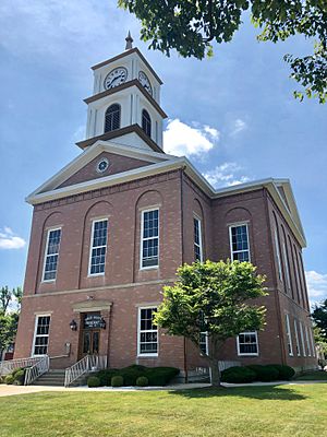
Ripley County Courthouse in Versailles
|
|

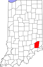
Location within the U.S. state of Indiana
|
|
 Indiana's location within the U.S. |
|
| Country | |
| State | |
| Founded | December 27, 1816 |
| Named for | Eleazer Wheelock Ripley |
| Seat | Versailles |
| Largest city | Batesville |
| Area | |
| • Total | 448.06 sq mi (1,160.5 km2) |
| • Land | 446.43 sq mi (1,156.2 km2) |
| • Water | 1.64 sq mi (4.2 km2) 0.37%% |
| Population
(2020)
|
|
| • Total | 28,995 |
| • Density | 64.7123/sq mi (24.9856/km2) |
| Time zone | UTC−5 (Eastern) |
| • Summer (DST) | UTC−4 (EDT) |
| Congressional district | 6th |
| Website | http://www.ripleycounty.com/ |
| Indiana county number 69 FIPS Code 137 |
|
Ripley County is a county located at the southeastern corner of the U.S. state of Indiana. According to the 2020 Census, the population was 28,995. The county seat is Versailles.
Contents
History
Ripley County was formed on December 27, 1816, in the same legislative act that created Jennings County. It was named for Gen. Eleazer Wheelock Ripley, an officer in the War of 1812, who figured in the Battle of Lundy's Lane and the Siege of Fort Erie during 1814.
Geography
The county seat of Ripley County is Versailles, Indiana. It was selected as the county seat in 1818, and was laid out in 1819.
According to the 2010 census, the county has a total area of 448.06 square miles (1,160.5 km2), of which 446.43 square miles (1,156.2 km2) (or 99.64%) is land and 1.64 square miles (4.2 km2) (or 0.37%) is water.
| Township | Established Year | Area mi2 | Area km2 | Population | Incorporated Towns |
|---|---|---|---|---|---|
| Adams | 1858 | 43.79 | 113.42 | 5119 | Batesville (part), Sunman |
| Brown | 1823 | 53.67 | 139 | 1597 | |
| Center | 1858 | 29.51 | 76.43 | 2657 | Osgood |
| Delaware | 1823 | 33.27 | 86.17 | 1437 | |
| Franklin | 1823 | 36.6 | 94.79 | 3773 | Milan (part) |
| Jackson | 1823 | 29.87 | 77.36 | 965 | Napoleon |
| Johnson | 1823 | 54.98 | 142.4 | 3685 | Versailles |
| Laughery | 1819 | 25.97 | 67.26 | 4736 | Batesville (part) |
| Otter Creek | 1858 | 41.69 | 107.98 | 1410 | Holton |
| Shelby | 1823 | 69.39 | 179.72 | 999 | |
| Washington | 1823 | 29.33 | 75.96 | 2440 | Milan (part) |
| Ripley County | 1816 | 448.06 | 1160.471 | 28,181 |
Unincorporated communities
- Allen Crossing
- Ballstown
- Behlmer Corner
- Benham
- Clinton
- Correct
- Cross Plains
- Cross Roads
- Dabney
- Delaware
- Dewberry
- Elrod
- Friendship
- Haney Corner
- Jackson
- Jolleyville
- Laugheryville
- Lookout
- Morris
- Negangards Corner
- New Carrollton
- New Marion
- Old Milan
- Olean
- Otter Village
- Penntown
- Pierceville
- Prattsburg
- Rexville
- Spades
- Stringtown
- Stumpke Corner
Ghost towns
Adjacent counties
- Dearborn County (east)
- Decatur County (northwest)
- Franklin County (north)
- Jefferson County (south)
- Jennings County (west)
- Ohio County (east–southeast)
- Switzerland County (at southeast tip)
Major highways
 Interstate 74 – runs east–west across northern tip of county.
 US Route 50 – runs east–west across middle of county, through Holton and Versailles.
 US Route 421 - enters from Decatur County near northwest tip of Ripley County. Runs SSE to Versailles, then SSW into Jefferson County.
 State Road 46 – runs east–west across northern tip of county, paralleling Interstate 74 on its south side.
 State Road 48 – runs east–west across upper portion of county, through Napoleon.
 State Road 62 – begins at intersection with State Road 129, north of Cross Plains. Runs east through Friendship to Dearborn County.
 State Road 101 – begins at intersection with US Route 50 near east county line. Runs north to Penntown.
 State Road 129 – begins at intersection with State Road 46 east of Batesville, runs south to Versailles, then SSE through Cross Plains into Switzerland County.
 State Road 229 – enters from Franklin County at Batesville, runs SSW to Ballstown then south and west to Napoleon. Runs west to Decatur County.
 State Road 350 – begins at intersection with US 421 at Osgood, runs east through Delaware and Pierceville into Dearborn County.
National protected area
- Big Oaks National Wildlife Refuge (part)
Climate and weather
| Weather chart for Versailles, Indiana | |||||||||||||||||||||||||||||||||||||||||||||||
|---|---|---|---|---|---|---|---|---|---|---|---|---|---|---|---|---|---|---|---|---|---|---|---|---|---|---|---|---|---|---|---|---|---|---|---|---|---|---|---|---|---|---|---|---|---|---|---|
| J | F | M | A | M | J | J | A | S | O | N | D | ||||||||||||||||||||||||||||||||||||
|
3.1
35
18
|
2.7
40
21
|
3.8
51
30
|
4.1
62
38
|
5.3
71
47
|
4
79
57
|
3.9
84
61
|
4.6
82
59
|
2.9
76
51
|
3
65
40
|
3.1
52
32
|
3.5
40
23
|
||||||||||||||||||||||||||||||||||||
| temperatures in °F precipitation totals in inches source: The Weather Channel |
|||||||||||||||||||||||||||||||||||||||||||||||
|
Metric conversion
|
|||||||||||||||||||||||||||||||||||||||||||||||
In recent years, average temperatures in Versailles have ranged from a low of 18 °F (−8 °C) in January to a high of 84 °F (29 °C) in July, although a record low of −28 °F (−33 °C) was recorded in January 1994 and a record high of 100 °F (38 °C) was recorded in July 1999. Average monthly precipitation ranged from 2.71 inches (69 mm) in February to 5.27 inches (134 mm) in May.
Demographics
| Historical population | |||
|---|---|---|---|
| Census | Pop. | %± | |
| 1820 | 1,822 | — | |
| 1830 | 3,989 | 118.9% | |
| 1840 | 10,392 | 160.5% | |
| 1850 | 14,820 | 42.6% | |
| 1860 | 19,054 | 28.6% | |
| 1870 | 20,977 | 10.1% | |
| 1880 | 21,627 | 3.1% | |
| 1890 | 19,350 | −10.5% | |
| 1900 | 19,881 | 2.7% | |
| 1910 | 19,452 | −2.2% | |
| 1920 | 18,694 | −3.9% | |
| 1930 | 18,078 | −3.3% | |
| 1940 | 18,898 | 4.5% | |
| 1950 | 18,763 | −0.7% | |
| 1960 | 20,641 | 10.0% | |
| 1970 | 21,138 | 2.4% | |
| 1980 | 24,398 | 15.4% | |
| 1990 | 24,616 | 0.9% | |
| 2000 | 26,523 | 7.7% | |
| 2010 | 28,818 | 8.7% | |
| 2020 | 28,995 | 0.6% | |
| 2023 (est.) | 29,227 | 1.4% | |
| U.S. Decennial Census 1790-1960 1900-1990 1990-2000 2010 |
|||
As of the 2010 United States Census, there were 28,818 people, 10,789 households, and 7,910 families residing in the county. The population density was 64.6 inhabitants per square mile (24.9/km2). There were 11,952 housing units at an average density of 26.8 per square mile (10.3/km2). The racial makeup of the county was 97.6% white, 0.5% Asian, 0.2% American Indian, 0.2% black or African American, 0.5% from other races, and 0.9% from two or more races. Those of Hispanic or Latino origin made up 1.5% of the population. In terms of ancestry, 43.4% were German, 14.2% were American, 13.9% were Irish, and 8.7% were English.
Of the 10,789 households, 36.2% had children under the age of 18 living with them, 58.1% were married couples living together, 10.2% had a female householder with no husband present, 26.7% were non-families, and 22.8% of all households were made up of individuals. The average household size was 2.63 and the average family size was 3.08. The median age was 39.2 years.
The median income for a household in the county was $47,697 and the median income for a family was $57,305. Males had a median income of $41,711 versus $31,927 for females. The per capita income for the county was $22,025. About 7.5% of families and 9.8% of the population were below the poverty line, including 14.3% of those under age 18 and 8.6% of those age 65 or over.
Education
School districts include:
- Batesville Community School Corporation
- Jac-Cen-Del Community School Corporation
- Milan Community Schools
- South Ripley Community School Corporation
- Sunman-Dearborn Community School Corporation
See also
 In Spanish: Condado de Ripley (Indiana) para niños

