Jefferson County, Indiana facts for kids
Quick facts for kids
Jefferson County
|
|
|---|---|

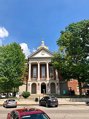
Jefferson County Courthouse in Madison
|
|

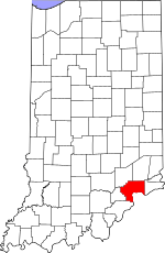
Location within the U.S. state of Indiana
|
|
 Indiana's location within the U.S. |
|
| Country | |
| State | |
| Founded | 1811 |
| Named for | Thomas Jefferson |
| Seat | Madison |
| Largest city | Madison |
| Area | |
| • Total | 362.89 sq mi (939.9 km2) |
| • Land | 360.63 sq mi (934.0 km2) |
| • Water | 2.26 sq mi (5.9 km2) 0.62%% |
| Population
(2020)
|
|
| • Total | 33,147 |
| • Estimate
(2023)
|
33,056 |
| • Density | 91.3417/sq mi (35.2672/km2) |
| Time zone | UTC−5 (Eastern) |
| • Summer (DST) | UTC−4 (EDT) |
| Congressional district | 6th |
| Indiana county number 39 | |
Jefferson County is a county located in the U.S. state of Indiana. As of 2020, the population was 33,147. The county seat is Madison.
Contents
History
Jefferson County was formed on February 1, 1811, from Dearborn and Clark Counties. It was named for Thomas Jefferson, principal draftsman of the Northwest Ordinance and President of the United States from 1801 through 1809.
Jefferson County was one of Indiana's first counties, and many important early Hoosiers came from Madison, including William Hendricks. Throughout the early history of the state, Madison was one of the leading cities competing with Vincennes, and later New Albany, to be the largest city in the state. The county fell into economic decline after the American Civil War, as industry began to shift from southern Indiana to the northern part of the state.
On the evening of May 20, 2009, the county courthouse caught fire. The fire began in the steeple of the courthouse, which was under reconstruction for Madison's bicentenary. The roof of the dome had just been painted gold. Fire departments from across southern Indiana and northern Kentucky arrived to put out the fire, which burned for several hours, destroyed much of the inside of the building and the county records. The fire forced the evacuation of the nearby county jail, and effectively shut down the downtown area of the city. It was later determined the fire was accidentally started by workers who were welding on the metal roof dome.
The tallest waterfall in Indiana, Fremont Falls, is located in Hanover.
Geography
According to the 2010 census, the county has a total area of 362.89 square miles (939.9 km2), of which 360.63 square miles (934.0 km2) (or 99.38%) is land and 2.26 square miles (5.9 km2) (or 0.62%) is water. Jefferson County makes up the Madison, IN Micropolitan Statistical Area.
Cities and towns
- Brooksburg
- Dupont
- Hanover
- Madison (county seat)
Census-designated places
Townships
- Graham
- Hanover
- Lancaster
- Madison
- Milton
- Monroe
- Republican
- Saluda
- Shelby
- Smyrna
Adjacent counties
- Ripley County (north)
- Switzerland County (east)
- Carroll County, Kentucky (southeast)
- Trimble County, Kentucky (south)
- Clark County (southwest)
- Scott County (west)
- Jennings County (northwest)
Major highways
Sources: National Atlas, U.S. Census Bureau
National protected area
- Big Oaks National Wildlife Refuge (part)
Climate and weather
| Weather chart for Madison, Indiana | |||||||||||||||||||||||||||||||||||||||||||||||
|---|---|---|---|---|---|---|---|---|---|---|---|---|---|---|---|---|---|---|---|---|---|---|---|---|---|---|---|---|---|---|---|---|---|---|---|---|---|---|---|---|---|---|---|---|---|---|---|
| J | F | M | A | M | J | J | A | S | O | N | D | ||||||||||||||||||||||||||||||||||||
|
3.1
39
23
|
3
44
26
|
4.3
55
34
|
4.3
65
43
|
5
75
53
|
4.4
83
62
|
4.4
87
66
|
4.1
85
65
|
2.9
79
57
|
3.2
67
45
|
3.8
55
36
|
3.7
44
27
|
||||||||||||||||||||||||||||||||||||
| temperatures in °F precipitation totals in inches source: The Weather Channel |
|||||||||||||||||||||||||||||||||||||||||||||||
|
Metric conversion
|
|||||||||||||||||||||||||||||||||||||||||||||||
In recent years, average temperatures in Madison have ranged from a low of 23 °F (−5 °C) in January to a high of 87 °F (31 °C) in July, although a record low of −18 °F (−28 °C) was recorded in December 1989 and a record high of 108 °F (42 °C) was recorded in July 1954. Average monthly precipitation ranged from 2.92 inches (74 mm) in September to 4.96 inches (126 mm) in May.
Demographics
| Historical population | |||
|---|---|---|---|
| Census | Pop. | %± | |
| 1820 | 8,038 | — | |
| 1830 | 11,465 | 42.6% | |
| 1840 | 16,614 | 44.9% | |
| 1850 | 23,916 | 44.0% | |
| 1860 | 25,036 | 4.7% | |
| 1870 | 29,741 | 18.8% | |
| 1880 | 25,977 | −12.7% | |
| 1890 | 24,507 | −5.7% | |
| 1900 | 22,913 | −6.5% | |
| 1910 | 20,483 | −10.6% | |
| 1920 | 20,709 | 1.1% | |
| 1930 | 19,182 | −7.4% | |
| 1940 | 19,912 | 3.8% | |
| 1950 | 21,613 | 8.5% | |
| 1960 | 24,061 | 11.3% | |
| 1970 | 27,006 | 12.2% | |
| 1980 | 30,419 | 12.6% | |
| 1990 | 29,797 | −2.0% | |
| 2000 | 31,705 | 6.4% | |
| 2010 | 32,428 | 2.3% | |
| 2020 | 33,147 | 2.2% | |
| 2023 (est.) | 33,056 | 1.9% | |
| U.S. Decennial Census 1790-1960 1900-1990 1990-2000 2010-2013 |
|||
As of the 2010 United States Census, there were 32,428 people, 12,635 households, and 8,456 families residing in the county. The population density was 89.9 inhabitants per square mile (34.7/km2). There were 14,311 housing units at an average density of 39.7 per square mile (15.3/km2). The racial makeup of the county was 95.2% white, 1.7% black or African American, 0.7% Asian, 0.2% American Indian, 0.9% from other races, and 1.3% from two or more races. Those of Hispanic or Latino origin made up 2.3% of the population. In terms of ancestry, 23.5% were German, 15.4% were American, 12.9% were Irish, and 11.2% were English.
Of the 12,635 households, 31.4% had children under the age of 18 living with them, 50.5% were married couples living together, 11.4% had a female householder with no husband present, 33.1% were non-families, and 27.2% of all households were made up of individuals. The average household size was 2.42 and the average family size was 2.90. The median age was 39.7 years.
The median income for a household in the county was $47,697 and the median income for a family was $52,343. Males had a median income of $42,629 versus $30,475 for females. The per capita income for the county was $21,278. About 10.2% of families and 15.1% of the population were below the poverty line, including 22.1% of those under age 18 and 10.1% of those age 65 or over.
Education
All Jefferson County residents five years and older are eligible to obtain a free library card from the Jefferson County Public Library in Madison. The public school system in Jefferson County is Madison Consolidated Schools.
See also
 In Spanish: Condado de Jefferson (Indiana) para niños

