Jennings County, Indiana facts for kids
Quick facts for kids
Jennings County
|
|
|---|---|

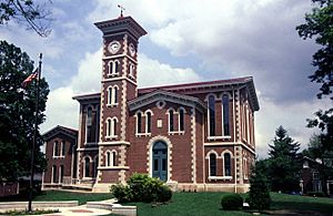
Jennings County courthouse in Vernon, Indiana
|
|

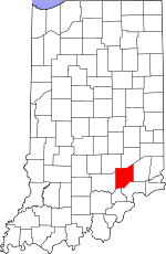
Location within the U.S. state of Indiana
|
|
 Indiana's location within the U.S. |
|
| Country | |
| State | |
| Founded | 1817 |
| Named for | Jonathan Jennings |
| Seat | Vernon |
| Largest city | North Vernon |
| Area | |
| • Total | 378.34 sq mi (979.9 km2) |
| • Land | 376.58 sq mi (975.3 km2) |
| • Water | 1.76 sq mi (4.6 km2) 0.47%% |
| Population
(2020)
|
|
| • Total | 27,613 |
| • Density | 72.9846/sq mi (28.1795/km2) |
| Time zone | UTC−5 (Eastern) |
| • Summer (DST) | UTC−4 (EDT) |
| Congressional district | 6th |
| Indiana county number 40 | |
Jennings County is a county located in the U.S. state of Indiana. As of 2020, the population was 27,613. The county seat is Vernon.
Contents
History
Jennings County was formed in 1817. It was named for the first Governor of Indiana and a nine-term congressman, Jonathan Jennings. Jennings was governor when the county was organized.
Geography
According to the 2010 census, the county has a total area of 378.34 square miles (979.9 km2), of which 376.58 square miles (975.3 km2) (or 99.53%) is land and 1.76 square miles (4.6 km2) (or 0.47%) is water. It is a rural county, with majority of the county consisting of personal farms and woodlands. There are only two incorporated towns in this county, Vernon, the county seat, and North Vernon. Both are quite small and underdeveloped by urban standards. The county is located in the center of an imaginary triangle consisting of Indianapolis, IN, Cincinnati, OH, and Louisville, KY and requires only 11⁄4 hour drive time to any of these urban centers.
It is also home to the Muscatatuck Urban Training Center, located just outside North Vernon, at which various training exercises and scenarios are conducted for homeland security and other similar purposes.
City
Town
Census-designated places
Other unincorporated places
Townships
- Bigger
- Campbell
- Center
- Columbia
- Geneva
- Lovett
- Marion
- Montgomery
- Sand Creek
- Spencer
- Vernon
Adjacent counties
- Decatur County (north)
- Ripley County (east)
- Jefferson County (southeast)
- Scott County (south)
- Jackson County (west)
- Bartholomew County (northwest)
Major highways
Sources: National Atlas, U.S. Census Bureau
Parks and protected areas
- Big Oaks National Wildlife Refuge (part)
- Muscatatuck National Wildlife Refuge (part)
- Muscatatuck County Park
- Selmier State Forest
Climate and weather
| Weather chart for Vernon, Indiana | |||||||||||||||||||||||||||||||||||||||||||||||
|---|---|---|---|---|---|---|---|---|---|---|---|---|---|---|---|---|---|---|---|---|---|---|---|---|---|---|---|---|---|---|---|---|---|---|---|---|---|---|---|---|---|---|---|---|---|---|---|
| J | F | M | A | M | J | J | A | S | O | N | D | ||||||||||||||||||||||||||||||||||||
|
3
38
22
|
2.7
45
26
|
3.8
55
34
|
4.4
66
43
|
4.7
75
52
|
3.8
83
61
|
4.4
86
65
|
4.4
84
63
|
2.9
78
56
|
3.2
67
44
|
3.8
54
36
|
3.4
43
27
|
||||||||||||||||||||||||||||||||||||
| temperatures in °F precipitation totals in inches source: The Weather Channel |
|||||||||||||||||||||||||||||||||||||||||||||||
|
Metric conversion
|
|||||||||||||||||||||||||||||||||||||||||||||||
In recent years, average temperatures in Vernon have ranged from a low of 22 °F (−6 °C) in January to a high of 86 °F (30 °C) in July, although a record low of −24 °F (−31 °C) was recorded in January 1977 and a record high of 105 °F (41 °C) was recorded in July 1954. Average monthly precipitation ranged from 2.71 inches (69 mm) in February to 4.72 inches (120 mm) in May.
Demographics
| Historical population | |||
|---|---|---|---|
| Census | Pop. | %± | |
| 1820 | 2,000 | — | |
| 1830 | 3,974 | 98.7% | |
| 1840 | 8,829 | 122.2% | |
| 1850 | 12,096 | 37.0% | |
| 1860 | 14,749 | 21.9% | |
| 1870 | 16,218 | 10.0% | |
| 1880 | 16,453 | 1.4% | |
| 1890 | 14,608 | −11.2% | |
| 1900 | 15,757 | 7.9% | |
| 1910 | 14,203 | −9.9% | |
| 1920 | 13,280 | −6.5% | |
| 1930 | 11,800 | −11.1% | |
| 1940 | 13,680 | 15.9% | |
| 1950 | 15,250 | 11.5% | |
| 1960 | 17,267 | 13.2% | |
| 1970 | 19,454 | 12.7% | |
| 1980 | 22,854 | 17.5% | |
| 1990 | 23,661 | 3.5% | |
| 2000 | 27,554 | 16.5% | |
| 2010 | 28,525 | 3.5% | |
| 2020 | 27,613 | −3.2% | |
| 2023 (est.) | 27,622 | −3.2% | |
| U.S. Decennial Census 1790-1960 1900-1990 1990-2000 2010 |
|||
As of the 2010 United States Census, there were 28,525 people, 10,680 households, and 7,733 families residing in the county. The population density was 75.7 inhabitants per square mile (29.2/km2). There were 12,069 housing units at an average density of 32.0 per square mile (12.4/km2). The racial makeup of the county was 96.8% white, 0.8% black or African American, 0.2% Asian, 0.1% American Indian, 1.0% from other races, and 1.2% from two or more races. Those of Hispanic or Latino origin made up 2.0% of the population. In terms of ancestry, 26.2% were German, 16.3% were Irish, 14.7% were American, and 7.2% were English.
Of the 10,680 households, 36.8% had children under the age of 18 living with them, 54.7% were married couples living together, 11.5% had a female householder with no husband present, 27.6% were non-families, and 22.3% of all households were made up of individuals. The average household size was 2.64 and the average family size was 3.06. The median age was 38.4 years.
The median income for a household in the county was $47,697 and the median income for a family was $48,470. Males had a median income of $38,506 versus $27,633 for females. The per capita income for the county was $18,636. About 8.9% of families and 12.3% of the population were below the poverty line, including 16.1% of those under age 18 and 5.4% of those age 65 or over.
Education
Jennings County residents may obtain a library card from the Jennings County Public Library in North Vernon.
Notable residents
- Sarah T. Bolton, poet
- Ovid Butler, founder of Butler University
- Royce Campbell, jazz guitarist
- Cliff Daringer, Federal League baseball player
- Rolla Daringer, Major League Baseball player
- Lincoln Dixon, U.S. Representative from Indiana, 1905–1919
- Scott Earl, Major League Baseball player
- Robert Sanford Foster, Civil War General
- John "Spider" Miller, 2015 & 2017 Walker Cup team captain
- Jethro New, frontiersmen, Continental Army officer
- Jeptha D. New, U.S. Representative from Indiana, 1875–1877, 1879–1881
- John C. New, Treasurer of the United States, 1875–1876
- Horatio C. Newcomb, Mayor of Indianapolis, 1849–1851
- Hannah Milhous Nixon, mother of President Richard Nixon
- Pat O'Connor, polesitter for the 1957 Indianapolis 500 and member of the National Sprint Car Hall of Fame
- Mike Simon, Major League Baseball player
- Jessamyn West, author
- Edgar Whitcomb, 43rd Governor of Indiana
- Albert Edward Wiggam, psychologist, lecturer, and author
See also
 In Spanish: Condado de Jennings para niños

