Pocahontas County, Iowa facts for kids
Quick facts for kids
Pocahontas County
|
|
|---|---|

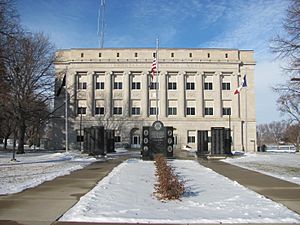
County Courthouse
|
|

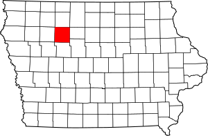
Location within the U.S. state of Iowa
|
|
 Iowa's location within the U.S. |
|
| Country | |
| State | |
| Founded | 1851 |
| Named for | Pocahontas |
| Seat | Pocahontas |
| Largest city | Pocahontas |
| Area | |
| • Total | 579 sq mi (1,500 km2) |
| • Land | 577 sq mi (1,490 km2) |
| • Water | 1.4 sq mi (4 km2) 0.2% |
| Population
(2020)
|
|
| • Total | 7,078 |
| • Density | 12.225/sq mi (4.720/km2) |
| Time zone | UTC−6 (Central) |
| • Summer (DST) | UTC−5 (CDT) |
| Congressional district | 4th |
Pocahontas County is a county located in Iowa, United States. As of the 2020 census the population was 7,078, making it the state's ninth-least populous county. The county seat is Pocahontas. The county was formed in 1851.
The county is named in honor of Pocahontas, the famous Native American woman from Jamestown, Virginia. A colossal statue of her stands in the city of Pocahontas.
Contents
Geography
According to the U.S. Census Bureau, the county has a total area of 579 square miles (1,500 km2), of which 577 square miles (1,490 km2) is land and 1.4 square miles (3.6 km2) (0.2%) is water.
Major highways
Adjacent counties
- Palo Alto County (north)
- Humboldt County (east)
- Webster County (southeast)
- Calhoun County (south)
- Buena Vista County (west)
Demographics
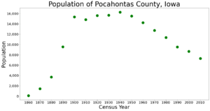
| Historical population | |||
|---|---|---|---|
| Census | Pop. | %± | |
| 1860 | 103 | — | |
| 1870 | 1,446 | 1,303.9% | |
| 1880 | 3,713 | 156.8% | |
| 1890 | 9,553 | 157.3% | |
| 1900 | 15,339 | 60.6% | |
| 1910 | 14,808 | −3.5% | |
| 1920 | 15,602 | 5.4% | |
| 1930 | 15,687 | 0.5% | |
| 1940 | 16,266 | 3.7% | |
| 1950 | 15,496 | −4.7% | |
| 1960 | 14,234 | −8.1% | |
| 1970 | 12,729 | −10.6% | |
| 1980 | 11,369 | −10.7% | |
| 1990 | 9,525 | −16.2% | |
| 2000 | 8,662 | −9.1% | |
| 2010 | 7,310 | −15.6% | |
| 2020 | 7,078 | −3.2% | |
| 2023 (est.) | 6,976 | −4.6% | |
| U.S. Decennial Census 1790-1960 1900-1990 1990-2000 2010-2018 |
|||
2020 census

The 2020 census recorded a population of 7,078 in the county, with a population density of 12.2213/sq mi (4.7187/km2). 95.79% of the population reported being of one race. There were 3,666 housing units, of which 3,090 were occupied.
| Race | Num. | Perc. |
|---|---|---|
| White (NH) | 6,383 | 90.2% |
| Black or African American (NH) | 66 | 0.9% |
| Native American (NH) | 10 | 0.14% |
| Asian (NH) | 29 | 0.41% |
| Pacific Islander (NH) | 23 | 0.32% |
| Other/Mixed (NH) | 213 | 3% |
| Hispanic or Latino | 354 | 5% |
2010 census
The 2010 census recorded a population of 7,310 in the county, with a population density of 12.654/sq mi (4.886/km2). There were 3,794 housing units, of which 3,233 were occupied.
Communities
Cities
Unincorporated communities
Townships
- Bellville
- Cedar
- Center
- Colfax
- Cummins
- Des Moines
- Dover
- Garfield
- Grant
- Lake
- Lincoln
- Lizard
- Marshall
- Powhatan
- Roosevelt
- Sherman
- Swan Lake
Population ranking
The population ranking of the following table is based on the 2020 census of Pocahontas County.
† county seat
| Rank | City/Town/etc. | Municipal type | Population (2020 Census) |
|---|---|---|---|
| 1 | † Pocahontas | City | 1,867 |
| 2 | Laurens | City | 1,264 |
| 3 | Fonda | City | 636 |
| 4 | Rolfe | City | 509 |
| 5 | Gilmore City (partially in Humboldt County) | City | 217 (487 total) |
| 6 | Palmer | City | 138 |
| 7 | Havelock | City | 130 |
| 8 | Varina | City | 68 |
| 9 | Plover | City | 50 |
See also
 In Spanish: Condado de Pocahontas (Iowa) para niños


