Calhoun County, Iowa facts for kids
Quick facts for kids
Calhoun County
|
|
|---|---|
|
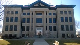
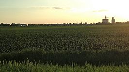
Clockwise from top: Calhoun County Courthouse in Rockwell City, the former Lake City Public Library, a grain elevator in the small town of Somers rises from a field at sunset, and the historic Central School in Lake City
|
|
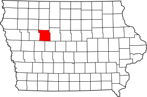
Location within the U.S. state of Iowa
|
|
 Iowa's location within the U.S. |
|
| Country | |
| State | |
| Founded | 1855 |
| Named for | John C. Calhoun |
| Seat | Rockwell City |
| Largest city | Rockwell City |
| Area | |
| • Total | 572 sq mi (1,480 km2) |
| • Land | 570 sq mi (1,500 km2) |
| • Water | 2.1 sq mi (5 km2) 0.4% |
| Population
(2020)
|
|
| • Total | 9,927 |
| • Density | 17.355/sq mi (6.701/km2) |
| Time zone | UTC−6 (Central) |
| • Summer (DST) | UTC−5 (CDT) |
| Congressional district | 4th |
Calhoun County is a county located in the U.S. state of Iowa. As of the 2020 census, the population was 9,927. Its county seat is Rockwell City.
Contents
History
Calhoun County was formed on January 15, 1851, from open land originally named Fox County. It was renamed in 1853 after the seventh US vice president secessionist John C. Calhoun. When the tracks of the Illinois Central Railroad were laid through the county in 1870, the county seat was moved from Lake City to Rockwell City. The first train reached Rockwell City on August 7, 1882, and the population count doubled in the same year. The first courthouse, built of wood, burned to the ground in 1884 and the county government moved into a nearby hotel. In 1913, the current courthouse was built.
On July 6, 1893, Pomeroy was struck by a tornado that measured F5 on the Fujita scale. With a damage path 500 yards (460 m) wide and 55 miles (89 km) long, the tornado destroyed about 80% of the homes in Pomeroy. The tornado killed 71 people and injured 200.
Geography
According to the U.S. Census Bureau, the county has a total area of 572 square miles (1,480 km2), of which 570 square miles (1,500 km2) is land and 2.1 square miles (5.4 km2) (0.4%) is water.
Ecology
Calhoun County is located entirely within the Des Moines Lobe of the Western Corn Belt Plains ecoregion, as defined by the United States Environmental Protection Agency (EPA). One of the flattest regions in Iowa, the Des Moines Lobe ecoregion is a distinctive area naturally defined by Wisconsin glaciation but modified by humans for extensive agriculture. In general, the land is level to gently rolling with some areas of relief defined by glacial features like moraines, hummocky knobs, and kettles, and outwash deposits. The lobe does not have any loess deposits like the Loess Hills to the west.
The stream network is poorly developed and widely spaced, with major rivers carving valleys that are relatively deep and steep-sided. Almost all of the natural lakes of Iowa are found in the northern part of this region (the Iowa Great Lakes). Most of the region has been converted from wet prairie to agricultural use with substantial surface water drainage. Only a small fraction of the wetlands remain, and many natural lakes have been drained as a result of agricultural drainage projects via drainage tiles or ditches.
Major highways
Adjacent counties
- Pocahontas County (north)
- Webster County (east)
- Greene County (southeast)
- Carroll County (southwest)
- Sac County (west)
Demographics
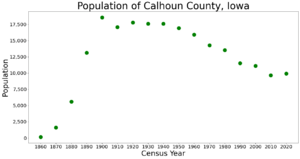
| Historical population | |||
|---|---|---|---|
| Census | Pop. | %± | |
| 1860 | 147 | — | |
| 1870 | 1,602 | 989.8% | |
| 1880 | 5,595 | 249.3% | |
| 1890 | 13,107 | 134.3% | |
| 1900 | 18,569 | 41.7% | |
| 1910 | 17,090 | −8.0% | |
| 1920 | 17,783 | 4.1% | |
| 1930 | 17,605 | −1.0% | |
| 1940 | 17,584 | −0.1% | |
| 1950 | 16,925 | −3.7% | |
| 1960 | 15,923 | −5.9% | |
| 1970 | 14,287 | −10.3% | |
| 1980 | 13,542 | −5.2% | |
| 1990 | 11,508 | −15.0% | |
| 2000 | 11,115 | −3.4% | |
| 2010 | 9,670 | −13.0% | |
| 2020 | 9,927 | 2.7% | |
| 2023 (est.) | 9,763 | 1.0% | |
| U.S. Decennial Census 1790-1960 1900-1990 1990-2000 2010-2018 |
|||
2020 census
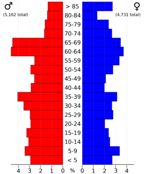
The 2020 census recorded a population of 9,927 in the county, with a population density of 17.3722/sq mi (6.7074/km2). 97.22% of the population reported being of one race. 91.88% were non-Hispanic White, 1.53% were Black, 2.38% were Hispanic, 0.24% were Native American, 0.26% were Asian, 0.08% were Native Hawaiian or Pacific Islander and 3.63% were some other race or more than one race. There were 4,771 housing units of which 4,070 were occupied.
2010 census
The 2010 census recorded a population of 9,670 in the county, with a population density of 16.96/sq mi (6.55/km2). There were 5,108 housing units, of which 4,242 were occupied.
Communities
Cities
Unincorporated communities
Townships
Calhoun County is divided into sixteen townships:
- Butler
- Calhoun
- Cedar
- Center
- Elm Grove
- Garfield
- Greenfield
- Jackson
- Lake Creek
- Lincoln
- Logan
- Reading
- Sherman
- Twin Lakes
- Union
- Williams
Population ranking
The population ranking of the following table is based on the 2020 census of Calhoun County.
† county seat
| Rank | City/Town/etc. | Municipal type | Population (2020 Census) |
|---|---|---|---|
| 1 | † Rockwell City | City | 2,240 |
| 2 | Lake City | City | 1,731 |
| 3 | Manson | City | 1,709 |
| 4 | Pomeroy | City | 526 |
| 5 | Farnhamville (partially in Webster County) | City | 383 |
| 6 | Lohrville | City | 381 |
| 7 | Twin Lakes | CDP | 316 |
| 8 | Lytton (mostly in Sac County) | City | 40 (282 total) |
| 9 | Somers | City | 128 |
| 10 | Knierim | City | 53 |
| 11 | Rinard | City | 38 |
| 12 | Jolley | City | 28 |
| 13 | Yetter | City | 19 |
See also
 In Spanish: Condado de Calhoun (Iowa) para niños


