Tornado facts for kids
Quick facts for kids Tornado |
|
|---|---|
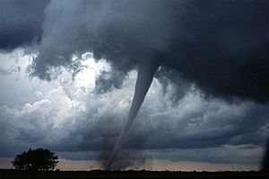
An F3 tornado near Anadarko, Oklahoma, 1999.
|
|
| Season | Primarily spring and summer, but can be at any time of year |
| Effect | Wind damage |
A tornado is a tube of violently spinning air that touches the ground. Wind inside the tornado spins fast, but the actual 'circle' of wind around them is huge. This makes tornadoes very dangerous. Tornadoes are especially dangerous to people in cars or mobile homes. About 60 people are killed by tornadoes every year.
The word tornado comes from the Spanish word tornado (past participle of 'to turn', or 'to have turned', which comes from the Latin tonare 'to thunder'.
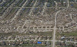
Tornadoes destroy things. They can tear houses to pieces and often leave people homeless. They are smaller than hurricanes but stronger. Nearly three quarters of the world's tornadoes happen in the United States. However, they can happen anywhere.
They cause a lot of damage to anything in their path. Tornadoes are ranked on the Enhanced Fujita scale, from EF0 to EF5. EF0 for tornados that caused the least damage, and EF5 for the ones that caused the most.
Tornadoes can happen in nearly any part of the world. In the United States, a tornado has happened in all states. The middle part of the United States is nicknamed 'Tornado Alley' for the number of tornadoes there. A tornado can have wind speeds of over 300 miles per hour (480 km/h).
Most tornadoes have wind speeds less than 110 miles per hour (180 km/h), are about 250 feet (80 m) across and travel a few miles before disappearing. Other tornado-like phenomena that exist in nature include the gustnado, dust devil, fire whirls, and steam devil; downbursts are frequently confused with tornadoes, though their action is not similar.
A "tornado watch" is given when the weather conditions look like a tornado could form. A 'PDS (Particularly Dangerous Situation)' watch is given when a likely tornado outbreak is to start, many strong tornadoes will form in the area, or an ongoing tornado outbreak is in the works in the area. A "tornado warning" is given if somebody has actually seen a tornado or if a tornado 'signature' (usually the storm has a 'hook' or 'U' echo) has shown up on radar. Tornado emergencies are issued in Special Weather Statements or Tornado Warnings saying that a powerful tornado is about to hit an area with a lot of people in it (especially cities in Tornado Alley), a tornado has been spotted, and the tornado is expected to cause deaths.
Contents
Characteristics
Size and shape
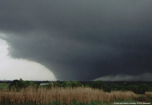
Most tornadoes take on the appearance of a narrow funnel, a few hundred meters (yards) across, with a small cloud of debris near the ground. Tornadoes may be obscured completely by rain or dust. These tornadoes are especially dangerous, as even experienced meteorologists might not see them.
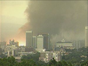
Small, relatively weak landspouts may be visible only as a small swirl of dust on the ground. Although the condensation funnel may not extend all the way to the ground, if associated surface winds are greater than 64 km/h (40 mph), the circulation is considered a tornado. A tornado with a nearly cylindrical profile and relatively low height is sometimes referred to as a "stovepipe" tornado. Large tornadoes which appear at least as wide as their cloud-to-ground height can look like large wedges stuck into the ground, and so are known as "wedge tornadoes" or "wedges". A wedge can be so wide that it appears to be a block of dark clouds, wider than the distance from the cloud base to the ground. Even experienced storm observers may not be able to tell the difference between a low-hanging cloud and a wedge tornado from a distance. Many, but not all major tornadoes are wedges.
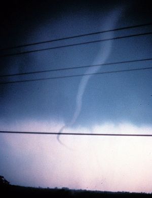
Tornadoes in the dissipating stage can resemble narrow tubes or ropes, and often curl or twist into complex shapes. These tornadoes are said to be "roping out", or becoming a "rope tornado". When they rope out, the length of their funnel increases, which forces the winds within the funnel to weaken. Multiple-vortex tornadoes can appear as a family of swirls circling a common center, or they may be completely obscured by condensation, dust, and debris, appearing to be a single funnel.
In the United States, tornadoes are around 500 feet (150 m) across on average. However, there is a wide range of tornado sizes. Weak tornadoes, or strong yet dissipating tornadoes, can be exceedingly narrow, sometimes only a few feet or couple meters across. One tornado was reported to have a damage path only 7 feet (2.1 m) long. On the other end of the spectrum, wedge tornadoes can have a damage path a mile (1.6 km) wide or more. A tornado that affected Hallam, Nebraska on May 22, 2004, was up to 2.5 miles (4.0 km) wide at the ground, and a tornado in El Reno, Oklahoma on May 31, 2013, was approximately 2.6 miles (4.2 km) wide, the widest on record.
Track length
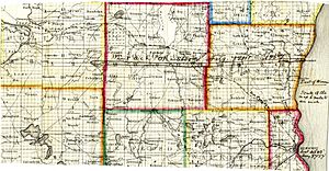
In the United States, the average tornado travels on the ground for 5 miles (8.0 km). However, tornadoes are capable of both much shorter and much longer damage paths: one tornado was reported to have a damage path only 7 feet (2.1 m) long, while the record-holding tornado for path length—the Tri-State Tornado, which affected parts of Missouri, Illinois, and Indiana on March 18, 1925—was on the ground continuously for 219 miles (352 km). Many tornadoes which appear to have path lengths of 100 miles (160 km) or longer are composed of a family of tornadoes which have formed in quick succession.
Appearance
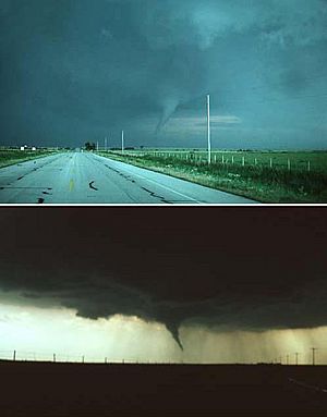
Tornadoes can have a wide range of colors, depending on the environment in which they form. Those that form in dry environments can be nearly invisible, marked only by swirling debris at the base of the funnel. Condensation funnels that pick up little or no debris can be gray to white. While traveling over a body of water (as a waterspout), tornadoes can turn white or even blue. Slow-moving funnels, which ingest a considerable amount of debris and dirt, are usually darker, taking on the color of debris. Tornadoes in the Great Plains can turn red because of the reddish tint of the soil, and tornadoes in mountainous areas can travel over snow-covered ground, turning white.
Lighting conditions are a major factor in the appearance of a tornado. A tornado which is "back-lit" (viewed with the sun behind it) appears very dark. The same tornado, viewed with the sun at the observer's back, may appear gray or brilliant white. Tornadoes which occur near the time of sunset can be many different colors, appearing in hues of yellow, orange, and pink.
Dust kicked up by the winds of the parent thunderstorm, heavy rain and hail, and the darkness of night are all factors that can reduce the visibility of tornadoes. Tornadoes occurring in these conditions are especially dangerous, since only weather radar observations, or possibly the sound of an approaching tornado, serve as any warning to those in the storm's path. Most significant tornadoes form under the storm's updraft base, which is rain-free, making them visible. Also, most tornadoes occur in the late afternoon, when the bright sun can penetrate even the thickest clouds.
There is mounting evidence, including Doppler on Wheels mobile radar images and eyewitness accounts, that most tornadoes have a clear, calm center with extremely low pressure, akin to the eye of tropical cyclones. Lightning is said to be the source of illumination for those who claim to have seen the interior of a tornado.
Rotation
Tornadoes normally rotate cyclonically (when viewed from above, this is counterclockwise in the northern hemisphere and clockwise in the southern).
Sound and seismology
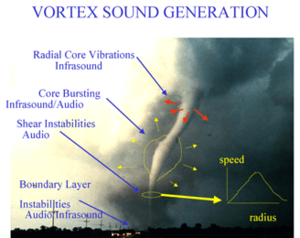
Various sounds of tornadoes have been reported. They include a freight train, rushing rapids or waterfall, a nearby jet engine, or combinations of these. Many tornadoes are not audible from much distance; the nature of and the propagation distance of the audible sound depends on atmospheric conditions and topography.
Since many tornadoes are audible only when very near, sound is not to be thought of as a reliable warning signal for a tornado.
How they form
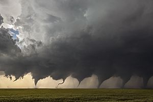
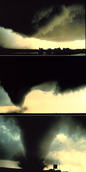
Classical tornadoes develop from a class of thunderstorms known as supercells. Supercells contain mesocyclones, an area of organized rotation a few kilometers/miles up in the atmosphere, usually 1.6–9.7 km (1–6 miles) across. Most intense tornadoes (EF3 to EF5 on the Enhanced Fujita Scale) develop from supercells. In addition to tornadoes, very heavy rain, frequent lightning, strong wind gusts, and hail are common in such storms.
Most tornadoes from supercells follow a recognizable life cycle which begins when increasing rainfall drags with it an area of quickly descending air known as the rear flank downdraft (RFD). This downdraft accelerates as it approaches the ground, and drags the supercell's rotating mesocyclone towards the ground with it.
Formation
The cycle begins when a strong thunderstorm develops a rotating mesocyclone a few miles up in the atmosphere. As rainfall in the storm increases, it drags with it an area of quickly descending air known as the rear flank downdraft (RFD). This downdraft accelerates as it approaches the ground, and drags the rotating mesocyclone towards the ground with it.
As the mesocyclone lowers below the cloud base, it begins to take in cool, moist air from the downdraft region of the storm. This convergence of warm air in the updraft, and this cool air, causes a rotating wall cloud to form. The RFD also focuses the mesocyclone's base, causing it to siphon air from a smaller and smaller area on the ground. As the updraft intensifies, it creates an area of low pressure at the surface. This pulls the focused mesocyclone down, in the form of a visible condensation funnel. As the funnel descends, the RFD also reaches the ground, creating a gust front that can cause severe damage a good distance from the tornado. Usually, the funnel cloud begins causing damage on the ground (becoming a tornado) within a few minutes of the RFD reaching the ground.
Field studies have shown that in order for a supercell to produce a tornado the RFD needs to be no more than a few Kelvin cooler than the updraft. Also the FFD (forward flank downdraft) seems to be warmer within tornadic supercells than in non-tornadic supercells.
Maturity
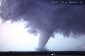
Initially, the tornado has a good source of warm, moist air flowing inward to power it, and it grows until it reaches the "mature stage". This can last from a few minutes to more than an hour, and during that time a tornado often causes the most damage, and in rare cases can be more than 1.6 km (1 mile) across. The low pressured atmosphere at the base of the tornado is essential to the endurance of the system. Meanwhile, the RFD, now an area of cool surface winds, begins to wrap around the tornado, cutting off the inflow of warm air which previously fed the tornado. The flow inside the funnel of the tornado is downward, supplying water vapor from the cloud above. This is contrary to the upward flow inside hurricanes, supplying water vapor from the warm ocean below.
Dissipation
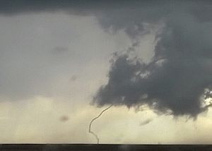
As the RFD completely wraps around and chokes off the tornado's air supply, the vortex begins to weaken, becoming thin and rope-like. This is the "dissipating stage", often lasting no more than a few minutes, after which the tornado ends. During this stage, the shape of the tornado becomes highly influenced by the winds of the parent storm, and can be blown into fantastic patterns. Even though the tornado is dissipating, it is still capable of causing damage. The storm is contracting into a rope-like tube and, due to conservation of angular momentum, winds can increase at this point.
Although this is a widely accepted theory for how most tornadoes form, live, and die, it does not explain the formation of smaller tornadoes, such as landspouts, long-lived tornadoes, or tornadoes with multiple vortices. These each have different mechanisms which influence their development—however, most tornadoes follow a pattern similar to this one.
Types
Multiple vortex
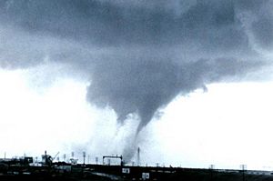
A multiple-vortex tornado is a type of tornado in which two or more columns of spinning air rotate about their own axes and at the same time revolve around a common center. A multi-vortex structure can occur in almost any circulation, but is very often observed in intense tornadoes. These vortices often create small areas of heavier damage along the main tornado path. This is a phenomenon that is distinct from a satellite tornado, which is a smaller tornado that forms very near a large, strong tornado contained within the same mesocyclone. The satellite tornado may appear to "orbit" the larger tornado (hence the name), giving the appearance of one, large multi-vortex tornado. However, a satellite tornado is a distinct circulation, and is much smaller than the main funnel.
Waterspout
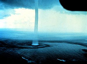
A waterspout is defined by the National Weather Service as a tornado over water. However, researchers typically distinguish "fair weather" waterspouts from tornadic (i.e. associated with a mesocyclone) waterspouts. Fair weather waterspouts are less severe but far more common, and are similar to dust devils and landspouts. They form at the bases of cumulus congestus clouds over tropical and subtropical waters. They have relatively weak winds, smooth laminar walls, and typically travel very slowly. They occur most commonly in the Florida Keys and in the northern Adriatic Sea. In contrast, tornadic waterspouts are stronger tornadoes over water. They form over water similarly to mesocyclonic tornadoes, or are stronger tornadoes which cross over water. Since they form from severe thunderstorms and can be far more intense, faster, and longer-lived than fair weather waterspouts, they are more dangerous. In official tornado statistics, waterspouts are generally not counted unless they affect land, though some European weather agencies count waterspouts and tornadoes together.
Landspout
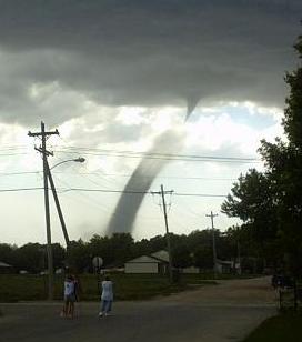
A landspout, or dust-tube tornado, is a tornado not associated with a mesocyclone. The name stems from their characterization as a "fair weather waterspout on land". Waterspouts and landspouts share many defining characteristics, including relative weakness, short lifespan, and a small, smooth condensation funnel that often does not reach the surface. Landspouts also create a distinctively laminar cloud of dust when they make contact with the ground, due to their differing mechanics from true mesoform tornadoes. Though usually weaker than classic tornadoes, they can produce strong winds which could cause serious damage.
Intensity and damage
| F0 EF0 |
F1 EF1 |
F2 EF2 |
F3 EF3 |
F4 EF4 |
F5 EF5 |
|---|---|---|---|---|---|
| Weak | Strong | Violent | |||
| Significant | |||||
| Intense | |||||
The Fujita scale and the Enhanced Fujita Scale rate tornadoes by damage caused. The Enhanced Fujita (EF) Scale was an update to the older Fujita scale. The EF Scale was designed so that a tornado rated on the Fujita scale would receive the same numerical rating, and was implemented starting in the United States in 2007. An EF0 tornado will probably damage trees but not substantial structures, whereas an EF5 tornado can rip buildings off their foundations leaving them bare and even deform large skyscrapers. The similar TORRO scale ranges from a T0 for extremely weak tornadoes to T11 for the most powerful known tornadoes. Doppler weather radar data, photogrammetry, and ground swirl patterns (cycloidal marks) may also be analyzed to determine intensity and award a rating.
Tornadoes vary in intensity regardless of shape, size, and location, though strong tornadoes are typically larger than weak tornadoes. The association with track length and duration also varies, although longer track tornadoes tend to be stronger. In the case of violent tornadoes, only a small portion of the path is of violent intensity, most of the higher intensity from subvortices.
In the United States, 80% of tornadoes are EF0 and EF1 (T0 through T3) tornadoes.
Outside Tornado Alley, and North America in general, violent tornadoes are extremely rare. This is apparently mostly due to the lesser number of tornadoes overall, as research shows that tornado intensity distributions are fairly similar worldwide. A few significant tornadoes occur annually in Europe, Asia, southern Africa, and southeastern South America.
Detection
Rigorous attempts to warn of tornadoes began in the United States in the mid-20th century. Before the 1950s, the only method of detecting a tornado was by someone seeing it on the ground. Often, news of a tornado would reach a local weather office after the storm. However, with the advent of weather radar, areas near a local office could get advance warning of severe weather. The first public tornado warnings were issued in 1950 and the first tornado watches and convective outlooks came about in 1952. In 1953, it was confirmed that hook echoes were associated with tornadoes. By recognizing these radar signatures, meteorologists could detect thunderstorms probably producing tornadoes from several miles away.
Radar
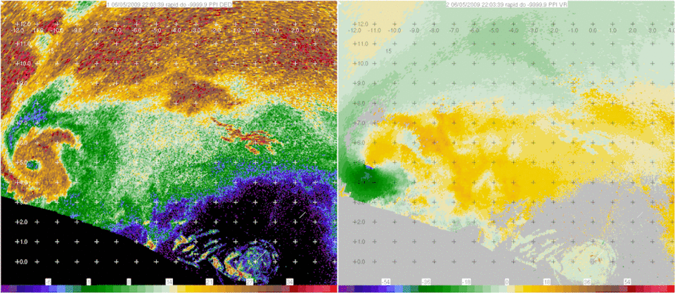
Today most developed countries have a network of weather radars, which serves as the primary method of detecting hook signatures that are likely associated with tornadoes. In the United States and a few other countries, Doppler weather radar stations are used. These devices measure the velocity and radial direction (towards or away from the radar) of the winds within a storm, and so can spot evidence of rotation in storms from over 160 km (100 miles) away. When storms are distant from a radar, only areas high within the storm are observed and the important areas below are not sampled. Data resolution also decreases with distance from the radar. Some meteorological situations leading to tornadogenesis are not readily detectable by radar and tornado development may occasionally take place more quickly than radar can complete a scan and send the batch of data. Doppler radar systems can detect mesocyclones within a supercell thunderstorm. This allows meteorologists to predict tornado formations throughout thunderstorms.
Storm spotting
Spotters usually are trained by the NWS on behalf of their respective organizations, and report to them. The organizations activate public warning systems such as sirens and the Emergency Alert System (EAS), and they forward the report to the NWS. There are more than 230,000 trained Skywarn weather spotters across the United States.
In Canada, a similar network of volunteer weather watchers, called Canwarn, helps spot severe weather, with more than 1,000 volunteers. In Europe, several nations are organizing spotter networks under the auspices of Skywarn Europe and the Tornado and Storm Research Organisation (TORRO) has maintained a network of spotters in the United Kingdom since 1974.
Storm spotters are required because radar systems such as NEXRAD detect signatures that suggest the presence of tornadoes, rather than tornadoes as such. Radar may give a warning before there is any visual evidence of a tornado or an imminent one, but ground truth from an observer can give definitive information. The spotter's ability to see what radar cannot is especially important as distance from the radar site increases, because the radar beam becomes progressively higher in altitude further away from the radar, chiefly due to curvature of Earth, and the beam also spreads out.
Visual evidence
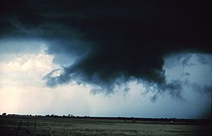
Storm spotters are trained to discern whether or not a storm seen from a distance is a supercell. They typically look to its rear, the main region of updraft and inflow. Under that updraft is a rain-free base, and the next step of tornadogenesis is the formation of a rotating wall cloud. The vast majority of intense tornadoes occur with a wall cloud on the backside of a supercell.
Evidence of a supercell is based on the storm's shape and structure, and cloud tower features such as a hard and vigorous updraft tower, a persistent, large overshooting top, a hard anvil (especially when backsheared against strong upper level winds), and a corkscrew look or striations. Under the storm and closer to where most tornadoes are found, evidence of a supercell and the likelihood of a tornado includes inflow bands (particularly when curved) such as a "beaver tail", and other clues such as strength of inflow, warmth and moistness of inflow air, how outflow- or inflow-dominant a storm appears, and how far is the front flank precipitation core from the wall cloud. Tornadogenesis is most likely at the interface of the updraft and rear flank downdraft, and requires a balance between the outflow and inflow.
Only wall clouds that rotate spawn tornadoes, and they usually precede the tornado between five and thirty minutes. Rotating wall clouds may be a visual manifestation of a low-level mesocyclone. Barring a low-level boundary, tornadogenesis is highly unlikely unless a rear flank downdraft occurs, which is usually visibly evidenced by evaporation of cloud adjacent to a corner of a wall cloud. A tornado often occurs as this happens or shortly afterwards; first, a funnel cloud dips and in nearly all cases by the time it reaches halfway down, a surface swirl has already developed, signifying a tornado is on the ground before condensation connects the surface circulation to the storm. Tornadoes may also develop without wall clouds, under flanking lines and on the leading edge. Spotters watch all areas of a storm, and the cloud base and surface.
Myths and misconceptions
It is often thought that opening windows will lessen the damage caused by a tornado. While there is a big drop in atmospheric pressure inside a strong tornado, it is unlikely that the pressure drop would be enough to cause the house to explode. Opening windows may actually increase the tornado's damage. A violent tornado can destroy a house whether its windows are open or closed. Another common misconception is that highway overpasses provide adequate shelter from tornadoes. Due to the Venturi effect, tornadic winds are stronger in the small space of an overpass. In the 1999 Oklahoma tornado outbreak of May 3, 1999, three highway overpasses were directly hit by tornadoes. At each of the three places there was a death, along with many life-threatening injuries. By comparison, during the same tornado outbreak, more than 2000 homes were completely destroyed, with another 7000 damaged, and yet only a few dozen people died in their homes.
There are areas which people believe to be safe from tornadoes, whether by being in a city, near a major river, hill, or mountain, or even protected by supernatural forces. Tornadoes have been known to cross major rivers, climb mountains, hit valleys, and have damaged several city centers. As a general rule, no area is safe from tornadoes, though some areas are more likely to be hit than others.
Safety tips
To keep safe in a tornado, here are some tips you can follow:
- Go to the lowest floor of the building. Stay close to the center of the building and away from windows, for example, a bathroom with no windows and get into the bathtub.
- Find a piece of strong furniture or a mattress to go under or hide in a closet and wait until it is over.
- If you are in a school, do not go to the gymnasium or any other place that has a high ceiling. Squat near the wall, placing your hands on the back of your head.
- If you cannot find shelter, find the lowest, most protected ground and cover your head with your hands.
- Do not drive in tornadoes. If you are in your car, position your head above the steering wheel, and cover yourself up.
- Do not seek shelter underneath an underpass or a bridge, as winds can send debris in your path.
Related pages
See also
 In Spanish: Tornado para niños


