Palo Alto County, Iowa facts for kids
Quick facts for kids
Palo Alto County
|
|
|---|---|

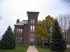
Palo Alto County Courthouse
|
|

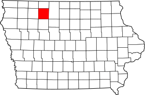
Location within the U.S. state of Iowa
|
|
 Iowa's location within the U.S. |
|
| Country | |
| State | |
| Founded | January 15, 1851 |
| Named for | Battle of Palo Alto |
| Seat | Emmetsburg |
| Largest city | Emmetsburg |
| Area | |
| • Total | 569 sq mi (1,470 km2) |
| • Land | 564 sq mi (1,460 km2) |
| • Water | 5.6 sq mi (15 km2) 1.0% |
| Population
(2020)
|
|
| • Total | 8,996 |
| • Density | 15.810/sq mi (6.104/km2) |
| Time zone | UTC−6 (Central) |
| • Summer (DST) | UTC−5 (CDT) |
| Congressional district | 4th |
Palo Alto County is a county located in the U.S. state of Iowa. As of the 2020 census, the population was 8,996. The county seat is Emmetsburg. It is named after the Battle of Palo Alto, the first major battle of the Mexican–American War.
Contents
Geography
According to the U.S. Census Bureau, the county has a total area of 569 square miles (1,470 km2), of which 564 square miles (1,460 km2) is land and 5.6 square miles (15 km2) (1.0%) is water.
Major highways
Adjacent counties
- Emmet County (north)
- Kossuth County (east)
- Pocahontas County (south)
- Clay County (west)
Demographics
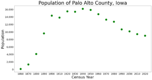
| Historical population | |||
|---|---|---|---|
| Census | Pop. | %± | |
| 1860 | 132 | — | |
| 1870 | 1,336 | 912.1% | |
| 1880 | 4,131 | 209.2% | |
| 1890 | 9,618 | 132.8% | |
| 1900 | 14,354 | 49.2% | |
| 1910 | 13,845 | −3.5% | |
| 1920 | 15,486 | 11.9% | |
| 1930 | 15,398 | −0.6% | |
| 1940 | 16,170 | 5.0% | |
| 1950 | 15,891 | −1.7% | |
| 1960 | 14,736 | −7.3% | |
| 1970 | 13,289 | −9.8% | |
| 1980 | 12,721 | −4.3% | |
| 1990 | 10,669 | −16.1% | |
| 2000 | 10,147 | −4.9% | |
| 2010 | 9,421 | −7.2% | |
| 2020 | 8,996 | −4.5% | |
| 2023 (est.) | 8,810 | −6.5% | |
| U.S. Decennial Census 1790–1960 1900–1990 1990–2000 2010–2018 |
|||
2020 census

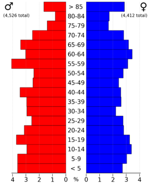
The 2020 census recorded a population of 8,996 in the county, with a population density of 15.8500/sq mi (6.1197/km2). 96.59% of the population reported being of one race. 91.05% were non-Hispanic White, 0.58% were Black, 3.05% were Hispanic, 0.26% were Native American, 0.43% were Asian, 0.07% were Native Hawaiian or Pacific Islander and 4.57% were some other race or more than one race. There were 4,516 housing units, of which 3,831 were occupied.
2010 census
The 2010 census recorded a population of 9,421 in the county, with a population density of 16.7089/sq mi (6.4513/km2). There were 4,628 housing units, of which 3,994 were occupied.
Communities
Cities
- Ayrshire
- Curlew
- Cylinder
- Emmetsburg
- Graettinger
- Mallard
- Rodman
- Ruthven
- West Bend (partially)
Townships
- Booth
- Ellington
- Emmetsburg
- Fairfield
- Fern Valley
- Freedom
- Great Oak
- Highland
- Independence
- Lost Island
- Nevada
- Rush Lake
- Silver Lake
- Vernon
- Walnut
- West Bend
Population ranking
The population ranking of the following table is based on the 2020 census of Palo Alto County.
† county seat
| Rank | City/Town/etc. | Municipal type | Population (2020 Census) |
|---|---|---|---|
| 1 | † Emmetsburg | City | 3,706 |
| 2 | Graettinger | City | 832 |
| 3 | West Bend (partially in Kossuth County) | City | 772 (791 total) |
| 4 | Ruthven | City | 725 |
| 5 | Mallard | City | 257 |
| 6 | Ayrshire | City | 133 |
| 7 | Cylinder | City | 87 |
| 8 | Curlew | City | 37 |
| 9 | Rodman | City | 31 |
See also
 In Spanish: Condado de Palo Alto para niños


