Emmetsburg, Iowa facts for kids
Quick facts for kids
Emmetsburg
|
|
|---|---|

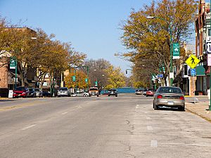
Street in Emmetsburg
|
|
| Nickname(s):
E-BURG
|
|
| Motto(s):
"Home of Five Island Lake"
|
|

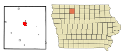
Location of Emmetsburg, Iowa
|
|
| Country | |
| State | |
| County | Palo Alto |
| Area | |
| • Total | 3.96 sq mi (10.25 km2) |
| • Land | 3.79 sq mi (9.82 km2) |
| • Water | 0.17 sq mi (0.43 km2) |
| Elevation | 1,237 ft (377 m) |
| Population
(2020)
|
|
| • Total | 3,706 |
| • Density | 977.32/sq mi (377.30/km2) |
| Time zone | UTC-6 (Central (CST)) |
| • Summer (DST) | UTC-5 (CDT) |
| ZIP code |
50536
|
| Area code(s) | 712 |
| FIPS code | 19-25590 |
| GNIS feature ID | 0456375 |
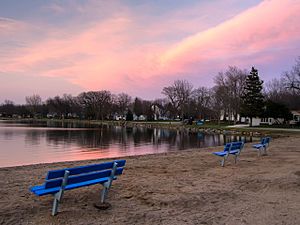
Emmetsburg is a city in Palo Alto County, Iowa, United States. The population was 3,706 at the time of the 2020 census. It is the county seat of Palo Alto County. Emmetsburg is located around the southern bay of Five Island Lake.
Contents
History
The town was originally settled by immigrants during the Great Famine of Ireland between 1845 and 1852. Emmetsburg was named after the Dublin-born Irish nationalist Robert Emmet, who was executed at 25 for leading an 1803 rebellion against the British. The city was incorporated on November 17, 1877.
Geography
The city lies just to the east of the Des Moines River.
According to the United States Census Bureau, the city has a total area of 3.97 square miles (10.28 km2), of which 3.81 square miles (9.87 km2) is land and 0.16 square miles (0.41 km2) is water.
Climate
According to the Köppen Climate Classification system, Emmetsburg has a hot-summer humid continental climate, abbreviated "Dfa" on climate maps.
| Climate data for Emmetsburg, Iowa, 1991–2020 normals, extremes 1893–present | |||||||||||||
|---|---|---|---|---|---|---|---|---|---|---|---|---|---|
| Month | Jan | Feb | Mar | Apr | May | Jun | Jul | Aug | Sep | Oct | Nov | Dec | Year |
| Record high °F (°C) | 65 (18) |
67 (19) |
86 (30) |
93 (34) |
100 (38) |
102 (39) |
106 (41) |
102 (39) |
99 (37) |
94 (34) |
81 (27) |
69 (21) |
106 (41) |
| Mean maximum °F (°C) | 46.2 (7.9) |
51.0 (10.6) |
68.0 (20.0) |
82.8 (28.2) |
89.3 (31.8) |
92.8 (33.8) |
94.0 (34.4) |
91.1 (32.8) |
89.3 (31.8) |
83.8 (28.8) |
66.1 (18.9) |
50.0 (10.0) |
95.3 (35.2) |
| Mean daily maximum °F (°C) | 26.2 (−3.2) |
31.2 (−0.4) |
43.8 (6.6) |
59.0 (15.0) |
71.1 (21.7) |
81.5 (27.5) |
84.8 (29.3) |
82.2 (27.9) |
75.7 (24.3) |
62.5 (16.9) |
45.5 (7.5) |
31.7 (−0.2) |
57.9 (14.4) |
| Daily mean °F (°C) | 16.8 (−8.4) |
21.4 (−5.9) |
33.8 (1.0) |
47.4 (8.6) |
59.8 (15.4) |
70.4 (21.3) |
74.1 (23.4) |
71.3 (21.8) |
63.5 (17.5) |
50.5 (10.3) |
35.5 (1.9) |
22.8 (−5.1) |
47.3 (8.5) |
| Mean daily minimum °F (°C) | 7.4 (−13.7) |
11.5 (−11.4) |
23.8 (−4.6) |
35.8 (2.1) |
48.6 (9.2) |
59.3 (15.2) |
63.3 (17.4) |
60.4 (15.8) |
51.2 (10.7) |
38.4 (3.6) |
25.5 (−3.6) |
13.9 (−10.1) |
36.6 (2.5) |
| Mean minimum °F (°C) | −13.9 (−25.5) |
−8.9 (−22.7) |
1.2 (−17.1) |
21.1 (−6.1) |
34.4 (1.3) |
46.4 (8.0) |
53.0 (11.7) |
49.2 (9.6) |
35.1 (1.7) |
22.7 (−5.2) |
7.0 (−13.9) |
−7.4 (−21.9) |
−16.4 (−26.9) |
| Record low °F (°C) | −33 (−36) |
−29 (−34) |
−26 (−32) |
5 (−15) |
22 (−6) |
38 (3) |
40 (4) |
38 (3) |
18 (−8) |
9 (−13) |
−11 (−24) |
−24 (−31) |
−33 (−36) |
| Average precipitation inches (mm) | 0.68 (17) |
0.93 (24) |
1.78 (45) |
3.70 (94) |
4.49 (114) |
5.54 (141) |
3.82 (97) |
4.36 (111) |
3.40 (86) |
2.37 (60) |
1.46 (37) |
1.06 (27) |
33.59 (853) |
| Average snowfall inches (cm) | 8.0 (20) |
8.2 (21) |
5.9 (15) |
2.6 (6.6) |
0.1 (0.25) |
0.0 (0.0) |
0.0 (0.0) |
0.0 (0.0) |
0.0 (0.0) |
0.3 (0.76) |
4.9 (12) |
7.1 (18) |
37.1 (93.61) |
| Average precipitation days (≥ 0.01 in) | 5.0 | 5.6 | 6.9 | 9.8 | 12.8 | 10.9 | 8.8 | 9.0 | 8.8 | 7.2 | 5.7 | 5.5 | 96 |
| Average snowy days (≥ 0.1 in) | 4.6 | 4.5 | 2.8 | 1.1 | 0.0 | 0.0 | 0.0 | 0.0 | 0.0 | 0.2 | 2.0 | 3.9 | 19.1 |
| Source 1: NOAA | |||||||||||||
| Source 2: National Weather Service | |||||||||||||
Demographics
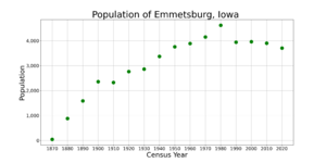
| Historical populations | ||
|---|---|---|
| Year | Pop. | ±% |
| 1870 | 44 | — |
| 1880 | 879 | +1897.7% |
| 1890 | 1,584 | +80.2% |
| 1900 | 2,361 | +49.1% |
| 1910 | 2,325 | −1.5% |
| 1920 | 2,762 | +18.8% |
| 1930 | 2,865 | +3.7% |
| 1940 | 3,374 | +17.8% |
| 1950 | 3,760 | +11.4% |
| 1960 | 3,887 | +3.4% |
| 1970 | 4,150 | +6.8% |
| 1980 | 4,621 | +11.3% |
| 1990 | 3,940 | −14.7% |
| 2000 | 3,958 | +0.5% |
| 2010 | 3,904 | −1.4% |
| 2020 | 3,706 | −5.1% |
| Source: and Iowa Data Center Source: |
||
2020 census
As of the census of 2020, there were 3,706 people, 1,598 households, and 927 families residing in the city. The population density was 977.2 inhabitants per square mile (377.3/km2). There were 1,832 housing units at an average density of 483.1 per square mile (186.5/km2). The racial makeup of the city was 92.8% White, 0.9% Black or African American, 0.4% Native American, 0.5% Asian, 0.1% Pacific Islander, 1.2% from other races and 4.1% from two or more races. Hispanic or Latino persons of any race comprised 3.3% of the population.
Of the 1,598 households, 25.2% of which had children under the age of 18 living with them, 43.4% were married couples living together, 6.5% were cohabitating couples, 29.1% had a female householder with no spouse or partner present and 21.0% had a male householder with no spouse or partner present. 42.0% of all households were non-families. 37.3% of all households were made up of individuals, 17.6% had someone living alone who was 65 years old or older.
The median age in the city was 43.2 years. 25.0% of the residents were under the age of 20; 5.8% were between the ages of 20 and 24; 20.9% were from 25 and 44; 23.6% were from 45 and 64; and 24.7% were 65 years of age or older. The gender makeup of the city was 48.2% male and 51.8% female.
2010 census
As of the census of 2010, there were 3,904 people, 1,632 households, and 967 families living in the city. The population density was 1,024.7 inhabitants per square mile (395.6/km2). There were 1,836 housing units at an average density of 481.9 per square mile (186.1/km2). The racial makeup of the city was 96.9% White, 1.0% African American, 0.2% Native American, 0.5% Asian, 0.3% from other races, and 1.1% from two or more races. Hispanic or Latino of any race were 2.0% of the population.
There were 1,632 households, of which 24.9% had children under the age of 18 living with them, 47.0% were married couples living together, 8.8% had a female householder with no husband present, 3.4% had a male householder with no wife present, and 40.7% were non-families. 34.3% of all households were made up of individuals, and 15.7% had someone living alone who was 65 years of age or older. The average household size was 2.22 and the average family size was 2.80.
The median age in the city was 41.4 years. 20.2% of residents were under the age of 18; 12.9% were between the ages of 18 and 24; 19.9% were from 25 to 44; 25.5% were from 45 to 64; and 21.6% were 65 years of age or older. The gender makeup of the city was 48.3% male and 51.7% female.
Education
Emmetsburg Community School District operates public schools. Emmetsburg also has a branch campus of Iowa Lakes Community College.
Sports
Emmetsburg hosted minor league baseball in 1912. The Emmetsburg team played as members of the Iowa State League, with home games played at Harrison Park.
Notable people
- Thomas Appelquist, theoretical physicist and dean of the Graduate School, Yale University; born in Emmetsburg
- Paul Brechler, athletic director of the University of Iowa and commissioner of the WAC; graduated from Emmetsburg High School
- Paul Emerick, USA international rugby player; born in Emmetsburg
- Matthew M. Joyce, former United States federal judge; born in Emmetsburg.
- Loren Meyer, retired American professional basketball player; born in Emmetsburg.
- Bruce Nelson, retired National Football League player; born in Emmetsburg
- Robert W. Pratt, District Judge for the United States District Court for the Southern District of Iowa; born in Emmetsburg
- Curt Pringle, former mayor of Anaheim, California and Speaker of the California State Assembly; born in Emmetsburg
See also
 In Spanish: Emmetsburg para niños


