Northfield, New Jersey facts for kids
Quick facts for kids
Northfield, New Jersey
|
||
|---|---|---|
|
City
|
||

Risley House
|
||
|
||
| Nickname(s):
"Gateway to the Shore"
|
||

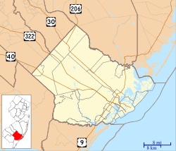
Map of Northfield in Atlantic County. Inset: Location of Atlantic County highlighted in the State of New Jersey.
|
||

Census Bureau map of Northfield, New Jersey
|
||
| Country | ||
| State | ||
| County | Atlantic | |
| Incorporated | March 21, 1905 | |
| Government | ||
| • Type | City | |
| • Body | City Council | |
| Area | ||
| • Total | 3.62 sq mi (9.37 km2) | |
| • Land | 3.58 sq mi (9.28 km2) | |
| • Water | 0.04 sq mi (0.09 km2) 0.97% | |
| Area rank | 310th of 565 in state 20th of 23 in county |
|
| Elevation | 23 ft (7 m) | |
| Population
(2020)
|
||
| • Total | 8,434 | |
| • Estimate
(2023)
|
8,426 | |
| • Rank | 281st of 565 in state 10th of 23 in county |
|
| • Density | 2,354.6/sq mi (909.1/km2) | |
| • Density rank | 262nd of 565 in state 6th of 23 in county |
|
| Time zone | UTC−05:00 (Eastern (EST)) | |
| • Summer (DST) | UTC−04:00 (Eastern (EDT)) | |
| ZIP Code |
08225
|
|
| Area code | 609 | |
| FIPS code | 3400152950 | |
| GNIS feature ID | 0885324 | |
| Website | ||
Northfield is a city in Atlantic County, in the U.S. state of New Jersey. As of the 2020 United States census, the city's population was 8,434, a decrease of 190 (−2.2%) from the 2010 census count of 8,624, which in turn reflected an increase of 899 (+11.6%) from the 7,725 counted in the 2000 census.
Northfield was founded by Jeremiah Leeds; he has a gravestone at Oxford Circle, but it is not certain that he was buried there. Northfield was incorporated as a city by an act of the New Jersey Legislature on March 21, 1905, from portions of Egg Harbor Township. A portion of Egg Harbor Township was transferred to Northfield in 1931, and then reverted to Egg Harbor Township in 1933.
The city calls itself the "Gateway to the Shore", just over the bridge from the beaches, and is located about 7 miles (11 km) west of Atlantic City, bordering the municipalities of Pleasantville, Egg Harbor Township and Linwood. Geographically, the city, and all of Atlantic County, is part of the South Jersey region of the state and of the Atlantic City-Hammonton metropolitan statistical area, which in turn is included in the Philadelphia-Reading-Camden combined statistical area and the Delaware Valley.
Contents
Geography
According to the United States Census Bureau, the city had a total area of 3.62 square miles (9.37 km2), including 3.58 square miles (9.28 km2) of land and 0.04 square miles (0.09 km2) of water (0.97%).
Unincorporated communities, localities and place names located partially or completely within the city include Bakersville and Dolphin.
The borough borders the Atlantic County municipalities of Egg Harbor Township, Linwood and Pleasantville.
Demographics
| Historical population | |||
|---|---|---|---|
| Census | Pop. | %± | |
| 1910 | 866 | — | |
| 1920 | 1,127 | 30.1% | |
| 1930 | 2,804 | 148.8% | |
| 1940 | 2,848 | 1.6% | |
| 1950 | 3,498 | 22.8% | |
| 1960 | 5,849 | 67.2% | |
| 1970 | 8,646 | 47.8% | |
| 1980 | 7,795 | −9.8% | |
| 1990 | 7,305 | −6.3% | |
| 2000 | 7,725 | 5.7% | |
| 2010 | 8,624 | 11.6% | |
| 2020 | 8,434 | −2.2% | |
| 2023 (est.) | 8,426 | −2.3% | |
| Population sources: 1900–2000 1900–1920 1910 1910–1930 1940–2000 2000 2010 2020 |
|||
2010 census
The 2010 United States census counted 8,624 people, 3,152 households, and 2,301 families in the city. The population density was 2,533.7 per square mile (978.3/km2). There were 3,260 housing units at an average density of 957.8 per square mile (369.8/km2). The racial makeup was 87.14% (7,515) White, 3.24% (279) Black or African American, 0.19% (16) Native American, 4.50% (388) Asian, 0.01% (1) Pacific Islander, 2.89% (249) from other races, and 2.04% (176) from two or more races. Hispanic or Latino of any race were 8.00% (690) of the population.
Of the 3,152 households, 34.7% had children under the age of 18; 55.2% were married couples living together; 13.1% had a female householder with no husband present and 27.0% were non-families. Of all households, 22.1% were made up of individuals and 11.5% had someone living alone who was 65 years of age or older. The average household size was 2.68 and the average family size was 3.15.
24.2% of the population were under the age of 18, 7.1% from 18 to 24, 21.3% from 25 to 44, 31.3% from 45 to 64, and 16.1% who were 65 years of age or older. The median age was 43.1 years. For every 100 females, the population had 91.2 males. For every 100 females ages 18 and older there were 87.0 males.
The Census Bureau's 2006–2010 American Community Survey showed that (in 2010 inflation-adjusted dollars) median household income was $70,980 (with a margin of error of +/− $5,377) and the median family income was $78,727 (+/− $5,763). Males had a median income of $57,027 (+/− $4,611) versus $45,757 (+/− $6,595) for females. The per capita income for the city was $30,675 (+/− $2,461). About 2.5% of families and 3.2% of the population were below the poverty line, including 3.8% of those under age 18 and 5.9% of those age 65 or over.
Parks and recreation
Northfield is home to Birch Grove Park, which covers 271 acres (110 ha) of heavily wooded land dotted with stocked fresh water fishing lakes. Birch Grove Park features over 50 campsites, exercise and nature trails, a bandstand and an extensive children's playground.
Northfield features a large bird sanctuary, dedicated to remaining open space in perpetuity.
Education
Students in public school for kindergarten through eighth grade are served by the Northfield Community Schools. As of the 2018–19 school year, the district, comprised of two schools, had an enrollment of 919 students and 82.9 classroom teachers (on an FTE basis), for a student–teacher ratio of 11.1:1. Schools in the district (with 2018–19 enrollment data from the National Center for Education Statistics) are Northfield Community Elementary School with 505 students in grades K–4 and Northfield Community Middle School with 409 students in grades 5–8.
Students in ninth through twelfth grades attend Mainland Regional High School, which serves students from Linwood, Northfield and Somers Point. The high school is located in Linwood. For the 1997–98 school year, Mainland Regional High School was recognized by the United States Department of Education as a National Blue Ribbon School. As of the 2018–19 school year, the high school had an enrollment of 1,226 students and 112.0 classroom teachers (on an FTE basis), for a student–teacher ratio of 10.9:1. Seats on the high school district's nine-member board of education are allocated based on population, with three seats assigned to Northfield.
City public school students are also eligible to attend the Atlantic County Institute of Technology in the Mays Landing section of Hamilton Township or the Charter-Tech High School for the Performing Arts, located in Somers Point. Students may also attend Holy Spirit High School, a Christian high school located in Abescon, New Jersey.
Holy Family Regional School in Ventnor, a K–8 school of the Roman Catholic Diocese of Camden formed in 2008, was co-sponsored by St. Gianna Beretta Church of Northfield. In 2011 the archdiocese closed the school.
Transportation

Roads and highways
As of May 2010[update], the city had a total of 46.41 miles (74.69 km) of roadways, of which 36.07 miles (58.05 km) were maintained by the municipality, 8.43 miles (13.57 km) by Atlantic County and 1.91 miles (3.07 km) by the New Jersey Department of Transportation.
U.S. Route 9 is the main highway directly serving Northfield, running south into Linwood and north into Pleasantville. Several major highways are accessible just outside the city, including the Garden State Parkway and the Atlantic City Expressway. These major highways provide connections to New York City, Philadelphia and Cape May.
Public transportation
NJ Transit offers bus transportation in the city between Ocean City and Atlantic City on the 507 and 509 routes.
Notable people
People who were born in, residents of, or otherwise closely associated with Northfield include:
- A. R. Ammons (1926–2001), author and poet, winner of the National Book Award
- Art Blakey (1919–1990), jazz drummer and bandleader
- Vince Mazzeo (born 1964), politician who has served in the New Jersey General Assembly since January 2014, before which he had served as the mayor of Northfield from 2008 through 2014
- Evelyn Nesbit (1884–1967), chorus girl, noted for her entanglement in the murder of her ex-lover, architect Stanford White, by her first husband, Harry K. Thaw
- Walter Fifield Snyder (1912–1993), scholar of ancient history
See also
 In Spanish: Northfield (Nueva Jersey) para niños


