Kathmandu Valley facts for kids
| UNESCO World Heritage Site | |
|---|---|

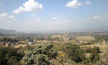
Kathmandu valley seen from Palanse, Bhaktapur
|
|
| Location | Province No. 3, Nepal |
| Inscription | 1979 (3rd Session) |
| Extensions | 2006 |
| Endangered | 2003–2007 |
| Area | 167.37 ha (413.6 acres) |
| Buffer zone | 70.29 ha (173.7 acres) |
The Kathmandu Valley (Nepali: काठमाडौं उपत्यका, Nepal Bhasa: स्वनिगः, नेपाः गाः), historically known as Nepal Valley or Nepa Valley, lies at the crossroads of ancient civilizations of South Asia and the broader Asian continent, and has at least 130 important monuments, including several pilgrimage sites for Hindus and Buddhists. There are seven World Heritage Sites within the valley.
Historically, the valley and adjoining areas made up a confederation known as the Nepal Mandala. Until the 15th century, Khwopa was its capital, when two other capitals, Kathmandu and Yala, were established. After the annexation of the valley by the Gorkha Kingdom, and subsequent conversion of the Valley as the capital of their empire, the designation of "Nepal" was extended to all the lands they had conquered.
Related pages
Images for kids
-
Pashupatinath Temple, dedicated to Pashupati.
See also
 In Spanish: Valle de Katmandú para niños


