Horseshoe Bend, Arkansas facts for kids
Quick facts for kids
Horseshoe Bend, Arkansas
|
||
|---|---|---|
|
||

Location of Horseshoe Bend in Fulton County and Izard County and Sharp County, Arkansas.
|
||
| Country | United States | |
| State | Arkansas | |
| Counties | Izard, Fulton, Sharp | |
| Area | ||
| • Total | 14.66 sq mi (37.96 km2) | |
| • Land | 13.36 sq mi (34.60 km2) | |
| • Water | 1.30 sq mi (3.36 km2) | |
| Elevation | 643 ft (196 m) | |
| Population
(2020)
|
||
| • Total | 2,440 | |
| • Density | 182.62/sq mi (70.51/km2) | |
| Time zone | UTC-6 (Central (CST)) | |
| • Summer (DST) | UTC-5 (CDT) | |
| ZIP code |
72512
|
|
| Area code(s) | 870 | |
| FIPS code | 05-33370 | |
| GNIS feature ID | 2404731 | |
Horseshoe Bend is a city in Fulton, Izard, and Sharp counties in the U.S. state of Arkansas. The population was 2,184 at the 2010 census. It is named for the large loop or horseshoe bend in the nearby Strawberry River.
Contents
Geography
The town is a 3-hour drive to Little Rock, Memphis, and Springfield.
According to the United States Census Bureau, the city has a total area of 14.6 square miles (38 km2), of which 13.4 square miles (35 km2) is land, and 1.2 square miles (3.1 km2) (8.50%) is water.
Demographics
| Historical population | |||
|---|---|---|---|
| Census | Pop. | %± | |
| 1970 | 321 | — | |
| 1980 | 1,909 | 494.7% | |
| 1990 | 2,239 | 17.3% | |
| 2000 | 2,278 | 1.7% | |
| 2010 | 2,184 | −4.1% | |
| 2020 | 2,440 | 11.7% | |
| U.S. Decennial Census | |||
2020 census
| Race | Number | Percentage |
|---|---|---|
| White (non-Hispanic) | 2,181 | 89.39% |
| Black or African American (non-Hispanic) | 11 | 0.45% |
| Native American | 17 | 0.7% |
| Asian | 9 | 0.37% |
| Pacific Islander | 3 | 0.12% |
| Other/Mixed | 144 | 5.9% |
| Hispanic or Latino | 75 | 3.07% |
As of the 2020 United States census, there were 2,440 people, 1,028 households, and 616 families residing in the city.
Municipal services
Police
The Horseshoe Bend Police Department was disbanded in 2013, its duties assumed by the Izard County Sheriff's office.
Fire
The Horseshoe Bend Volunteer Fire Department consists of 12 volunteers and covers 45 square miles of residential and commercial properties as well as wetlands. The Department is responsible for fire suppression, extrication assistance, HAZMAT, and rescue. Equipment includes one engine / pumper, one tanker, one brush / quick-attack vehicle, and one emergency rescue vehicle. The department currently has an Insurance Services Office, Inc. (ISO) Public Protection Classification (PPC™) Service rating of 6.
Animal Control
Animal Control maintains a facility where lost dogs and cats are kept for adoption. It is staffed by employees and volunteers. A five-day waiting period is observed with the hopes that the pet will be reunited with its owner. Animals must be spayed / neutered and vaccinated prior to adoption. Assistance with these fees is available through the Friends of Horseshoe Bend Animals.
Library
The Horseshoe Bend Library was created in 1974, evolving from bookmobile service from the White Country Regional Library in Batesville, Arkansas that began in 1970. The library was originally housed in the Municipal Building. In 2006, the Library relocated to its new facility on Club Rd. The Library serves the city and surrounding area with services such as audio / visual equipment, computer and Internet access, a media / meeting room, and traditional reading materials. The library is supported by Friends of the Library. Library grounds are maintained by Izard Country Master Gardeners.
Transportation
Major highways
Airport
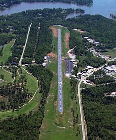
The Horseshoe Bend Airport, FAA identifier is 6M2, is owned and operated by the city. The runway is 4,524 ft. x 60 ft. and is paved. It is located at 36°13′3″N 91°45′3″W / 36.21750°N 91.75083°W (36.2213694, -91.7554833) at an elevation of 782 ft. / 238 m. Its variation is 03E.
See also
 In Spanish: Horseshoe Bend (Arkansas) para niños


