George County, Mississippi facts for kids
Quick facts for kids
George County
|
|
|---|---|

George County courthouse in Lucedale
|
|

Location within the U.S. state of Mississippi
|
|
 Mississippi's location within the U.S. |
|
| Country | |
| State | |
| Founded | 1910 |
| Named for | James Z. George |
| Seat | Lucedale |
| Largest city | Lucedale |
| Area | |
| • Total | 484 sq mi (1,250 km2) |
| • Land | 479 sq mi (1,240 km2) |
| • Water | 4.9 sq mi (13 km2) 1.0% |
| Population
(2020)
|
|
| • Total | 24,350 |
| • Estimate
(2023)
|
25,619 |
| • Density | 50.31/sq mi (19.425/km2) |
| Time zone | UTC−6 (Central) |
| • Summer (DST) | UTC−5 (CDT) |
| Congressional district | 4th |
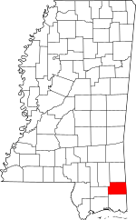
George County is a county located in the U.S. state of Mississippi. As of the 2020 census, the population was 24,350. Its county seat is Lucedale. The county is named for James Z. George, US Senator from Mississippi. George County was included in the Pascagoula, MS Metropolitan Statistical Area. The county is located adjacent to the Alabama state line.
Contents
History
George County was named after Senator James Z. George and was formed on March 16, 1910, from parts of land formerly included in Jackson and Greene Counties.
The Gulf, Mobile and Ohio Railroad ran through Lucedale on its way to Mobile.
Geography
According to the U.S. Census Bureau, the county has a total area of 484 square miles (1,250 km2), of which 479 square miles (1,240 km2) is land and 4.9 square miles (13 km2) (1.0%) is water.
Major highways
 U.S. Highway 98
 Mississippi Highway 26
 Mississippi Highway 57
 Mississippi Highway 63
 Mississippi Highway 198
Adjacent counties
- Greene County (north)
- Mobile County, Alabama (east)
- Jackson County (south)
- Stone County (west)
- Perry County (northwest)
National protected area
- De Soto National Forest (part)
Demographics
| Historical population | |||
|---|---|---|---|
| Census | Pop. | %± | |
| 1910 | 6,599 | — | |
| 1920 | 5,564 | −15.7% | |
| 1930 | 7,523 | 35.2% | |
| 1940 | 8,704 | 15.7% | |
| 1950 | 10,012 | 15.0% | |
| 1960 | 11,098 | 10.8% | |
| 1970 | 12,459 | 12.3% | |
| 1980 | 15,927 | 27.8% | |
| 1990 | 16,673 | 4.7% | |
| 2000 | 19,144 | 14.8% | |
| 2010 | 22,578 | 17.9% | |
| 2020 | 24,350 | 7.8% | |
| 2023 (est.) | 25,619 | 13.5% | |
| U.S. Decennial Census 1790-1960 1900-1990 1990-2000 2010-2013 |
|||
| Race | Num. | Perc. |
|---|---|---|
| White (non-Hispanic) | 20,929 | 85.95% |
| Black or African American (non-Hispanic) | 1,774 | 7.29% |
| Native American | 85 | 0.35% |
| Asian | 77 | 0.32% |
| Pacific Islander | 1 | 0.0% |
| Other/Mixed | 812 | 3.33% |
| Hispanic or Latino | 672 | 2.76% |
As of the 2020 United States census, there were 24,350 people, 7,592 households, and 5,309 families residing in the county.
Communities
City
- Lucedale (county seat)
Census-designated places
Unincorporated places
- Basin
- Bexley
- Crossroads
- Merrill
- Shipman
Education
The sole school district is George County School District.
See also
 In Spanish: Condado de George para niños

