Fertile Crescent facts for kids
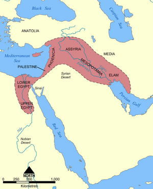
The Fertile Crescent is a historical region in the Middle East that includes the Levant, Mesopotamia and Ancient Egypt. These countries on a map together have a shape that is similar to a crescent, so archaeologist James Henry Breasted spoke of the "Fertile Crescent" because he wanted to show the similarities of the cultures of this region in ancient times.
All these lands are watered by important rivers: Nile, Jordan, Euphrates and Tigris. Together they cover some 400-500,000 square kilometers, and the region extends from the eastern shore of the Mediterranean Sea around the north of the Syrian Desert and through the Jazirah and Mesopotamia to the Persian Gulf. These areas are in present-day Egypt, Israel, West Bank, Gaza strip, and Lebanon and parts of Jordan, Syria, Iraq, south-eastern Turkey and south-western Iran. The population of the Nile River basin is about 70 million, the Jordan River basin about 20 million, and the Tigris and Euphrates basins about 30 million, giving the present-day Fertile Crescent a total population of around 120 million, or at least a quarter of the population of the Middle East.
The Fertile Crescent has a very long record of past human activity.
Related pages
Images for kids
-
A 15th century copy of Ptolemy's fourth Asian map, depicting the area known as the Fertile Crescent
-
1916 map of the Fertile Crescent by James H. Breasted, who popularised usage of the phrase.
-
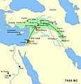
Area of the fertile crescent, circa 7500 BCE, with main sites of the Pre-Pottery Neolithic period. The area of Mesopotamia proper was not yet settled by humans. Includes Göbekli Tepe, a site in modern-day Turkey that is dated circa 9000 BCE.
See also
 In Spanish: Creciente Fértil para niños


