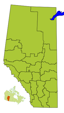
Division No. 10, Alberta facts for kids
Quick facts for kids
Division No. 10
|
|
|---|---|
|
Census division in Alberta
|
|
| Country | Canada |
| Province | Alberta |
| Area | |
| • Total | 20,450 km2 (7,900 sq mi) |
| Population
(2021)
|
|
| • Total | 95,455 |
| • Density | 4.6677/km2 (12.0894/sq mi) |
Division No. 10 is a census division in Alberta, Canada. It is located in the east-central portion of central Alberta and includes Alberta's portion of the City of Lloydminster.
Census subdivisions
The following census subdivisions (municipalities or municipal equivalents) are located within Alberta's Division No. 10.
- Cities
- Towns
- Villages
- Municipal districts
- Indian reserves
Demographics
| Historical population | ||
|---|---|---|
| Year | Pop. | ±% |
| 1991 | 78,491 | — |
| 1996 | 80,028 | +2.0% |
| 2001 | 83,061 | +3.8% |
| 2006 | 86,796 | +4.5% |
| 2011 | 93,039 | +7.2% |
| 2016 | 97,499 | +4.8% |
| 2021 | 95,455 | −2.1% |
In the 2021 Census of Population conducted by Statistics Canada, Division No. 10 had a population of 95,455 living in 38,161 of its 42,973 total private dwellings, a change of -2% from its 2016 population of 97,449. With a land area of 20,134.12 km2 (7,773.83 sq mi), it had a population density of 4.7/km2 (12/sq mi) in 2021.

All content from Kiddle encyclopedia articles (including the article images and facts) can be freely used under Attribution-ShareAlike license, unless stated otherwise. Cite this article:
Division No. 10, Alberta Facts for Kids. Kiddle Encyclopedia.

