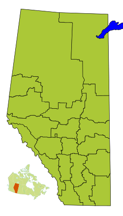
Division No. 1, Alberta facts for kids
Quick facts for kids
Division No. 1
|
|
|---|---|
|
Census division in Alberta
|
|
| Country | Canada |
| Province | Alberta |
| Area | |
| • Total | 20,526 km2 (7,925 sq mi) |
| Population
(2021)
|
|
| • Total | 82,513 |
| • Density | 4.01993/km2 (10.4116/sq mi) |
Division No. 1 is a census division in Alberta, Canada. It is located in the southeast corner of southern Alberta and surrounds the City of Medicine Hat. The division is made up of the counties of Cypress and Forty Mile No. 8.
Census subdivisions
The following census subdivisions (municipalities or municipal equivalents) are located within Alberta's Division No. 1.
- Cities
- Towns
- Villages
- Hamlets
- Municipal districts
Demographics
| Historical population | ||
|---|---|---|
| Year | Pop. | ±% |
| 1991 | 58,197 | — |
| 1996 | 62,330 | +7.1% |
| 2001 | 67,402 | +8.1% |
| 2006 | 74,550 | +10.6% |
| 2011 | 78,694 | +5.6% |
| 2016 | 82,627 | +5.0% |
| 2021 | 82,513 | −0.1% |
In the 2021 Census of Population conducted by Statistics Canada, Division No. 1 had a population of 82,513 living in 33,807 of its 36,097 total private dwellings, a change of -0.1% from its 2016 population of 82,627. With a land area of 20,277.52 km2 (7,829.19 sq mi), it had a population density of 4.1/km2 (11/sq mi) in 2021.
See also
 In Spanish: División n.º 1 (Alberta) para niños

All content from Kiddle encyclopedia articles (including the article images and facts) can be freely used under Attribution-ShareAlike license, unless stated otherwise. Cite this article:
Division No. 1, Alberta Facts for Kids. Kiddle Encyclopedia.

