Yellowstone River facts for kids
Quick facts for kids Yellowstone River |
|
|---|---|

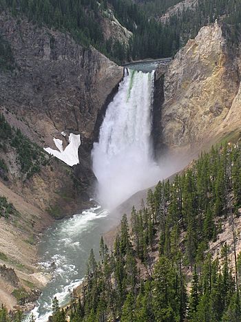
Yellowstone Falls on the Yellowstone River in Yellowstone National Park
|
|

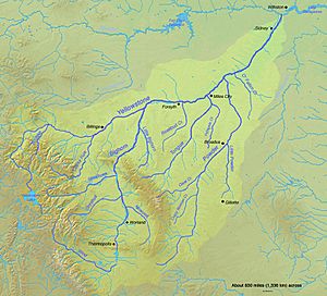
Map of the Yellowstone River watershed
|
|
| Country | United States |
| State | Wyoming, Montana, North Dakota |
| Physical characteristics | |
| Main source | Confluence of North and South Forks Absaroka Range, Wyoming 43°59′18″N 109°55′45″W / 43.98833°N 109.92917°W |
| River mouth | Missouri River McKenzie County, near Buford, North Dakota 47°58′42″N 103°58′56″W / 47.97833°N 103.98222°W |
| Length | 692 mi (1,114 km) |
| Basin features | |
| Basin size | 70,000 sq mi (180,000 km2) |
| Tributaries |
|
The Yellowstone River is a river in the northwestern part of the United States. It is a tributary of the Missouri River and flows through the states of Wyoming, Montana, and North Dakota. It also flows through Yellowstone National Park and feeds Yellowstone Lake.
The name is widely believed to have been derived from the Minnetaree Indian name Mi tse a-da-zi (Yellow Rock River) (Hidatsa: miʔciiʔriaashiish'). Common lore recounts that the name was inspired by the yellow-colored rocks along the Grand Canyon of the Yellowstone, but the Minnetaree never lived along the upper stretches of the Yellowstone. Some scholars think that the river was instead named after yellow-colored sandstone bluffs on the lower Yellowstone.
The Yellowstone River was first explored in 1806 by William Clark during the return trip of the Lewis and Clark Expedition.
Most of the natural features of the Yellowstone Valley not already named by Lewis and Clark were named by pioneer steamboat captain Grant Marsh. Marsh was selected by the Army for an exploratory expedition in 1873 on his riverboat Key West. The team was commanded by Brevet Brig. Gen. George Alexander Forsyth. Marsh kept a detailed log during the journey. The names he bestowed were recorded by an expedition representative of the War Department and applied to official maps; they include the following:
- Forsyth Butte, named in honor of Forsyth, commander of the expedition.
- Cut Nose Butte, Chimney Rock, and Diamond Island, for their resemblance to these objects.
- Seven Sisters Islands, in remembrance of Captain Marsh's seven sisters.
- Crittenden Island, for General T. L. Crittenden, who commanded the 17th Infantry, which was garrisoned at posts along the Missouri River.
- Mary Island, for the chambermaid on the Key West, wife of the steward, "Dutch Jake."
- Reno Island, for Major Marcus A. Reno, of the 7th Cavalry.
- Schindel Island, for Major M. Bryant, commanding the escort for the Key West.
- Edgerly Island, for Lieutenant W. S. Edgerly of the 7th Cavalry.
- Monroe Island, for Captain Marsh's brother, Monroe Marsh.
- DeRussy Rapids, for Isaac D. DeRussy, later lieutenant-colonel of the 14th Infantry.
- McCune Rapids (later misspelled "McKeon" on maps), for one of Marsh's longtime friends in St. Louis.
- Barr's Bluff, for another Marsh friend.
- Stanley's Point, for the colonel of the 22nd Infantry.
- Sheridan's Buttes, for Lt. Gen. Philip Sheridan.
The mainstem of the Yellowstone River is more than 700 miles (1,100 km) long.
There are no storage dams located on the mainstem of the Yellowstone River.
In Montana, the river's waters have been used extensively for irrigation since the 1860s.
In its upper reaches, within Yellowstone Park and the mountains of Montana, it is a popular destination for fly fishing.
The Yellowstone is a Class I river from the Yellowstone National Park boundary to the North Dakota border for the purposes of stream access for recreational purposes.
Yellowstone watershed
The Yellowstone River watershed is a river basin spanning 37,167 square miles (96,260 km2) across Montana, with minor extensions into Wyoming and North Dakota, toward headwaters and terminus, respectively. The Yellowstone Basin watershed contains a system of rivers, including the Yellowstone River, and four tributary basins: the Clarks Fork Yellowstone, Wind River and Bighorn River, Tongue River, and Powder River. These rivers form tributaries to the Missouri River.
The mainstem of the Yellowstone River is more than 700 miles (1,100 km) long. At the headwaters, elevations exceed 12,800 feet (3,900 m) above sea level and descends to 1,850 feet (560 m) at the confluence with the Missouri River in far western North Dakota. The watershed spans 34,167 square miles (88,490 km2). The area contains many lakes, including Yellowstone Lake. There are no storage dams located on the mainstem of the Yellowstone River. However, the watershed contains five major reservoirs built on tributary rivers: Bull Lake, Boysen, Buffalo Bill, Big Horn, Tongue River, and Lake De Smet reservoirs.
Geography
The river rises in northwestern Wyoming in the Absaroka Range, on the Continental Divide in southwestern Park County. The river starts where the North Fork and the South Fork of the Yellowstone River converge. The North Fork, the larger of the two forks, flows from Younts Peak. The South Fork flows from the southern slopes of Thorofare Mountain. The Yellowstone River flows northward through Yellowstone National Park, feeding and draining Yellowstone Lake, then dropping over the Upper and Lower Yellowstone Falls at the head of the Grand Canyon of the Yellowstone within the confines of the park. After passing through the Black Canyon of the Yellowstone downstream of the Grand Canyon, the river flows northward into Montana between the northern Absaroka Range and the Gallatin Range in Paradise Valley. The river emerges from the mountains near the town of Livingston, where it turns eastward and northeastward, flowing across the northern Great Plains past the city of Billings.
East of Billings, it is joined by the Bighorn River. Farther downriver, it is joined by the Tongue near Miles City, and then by the Powder in eastern Montana. It flows into the Missouri River near Buford, North Dakota just upstream from Lake Sakakawea. The latter is a reservoir formed in 1953 by the Garrison Dam, built on the Missouri River within the Fort Berthold Indian Reservation. It flooded the fertile bottomlands of the Affiliated Tribes (Mandan, Arikara, Hidatsa), damaging their economy and reducing their ability to be self-sufficient.
In Montana, the river's waters have been used extensively for irrigation since the 1860s. In its upper reaches, within Yellowstone Park and the mountains of Montana, it is a popular destination for fly fishing. The Yellowstone is a Class I river from the Yellowstone National Park boundary to the North Dakota border for the purposes of stream access for recreational purposes.
Water right claims
The division of water rights to the entire Yellowstone River Basin among Wyoming, Montana and North Dakota, governed by a 1950 compact, was disputed in a 2010 lawsuit brought directly to the U.S. Supreme Court by Montana against Wyoming. Oral argument took place in January 2011. On May 2, 2011, the Court held 7-2 (by Justice Thomas, with Justice Scalia dissenting) that Montana had no valid claim that its water supply had been diminished since Wyoming was irrigating the same acreage as always, albeit by a more modern method that returned less runoff to go downstream to Montana. (A subsequent 2011 Supreme Court case, in which Montana asserted ownership of Missouri Basin river bottoms, so as to collect decades of back rent from a hydropower company, is unrelated. On February 22, 2012, Montana lost that case too.)
Climate patterns
Flooding occurs in the watershed due to snowmelt, rainfall, and intense thunderstorms. In higher elevations, snowmelt can cause flood conditions due to rapid melt in spring and early summer. In lower elevations, regional rainstorms and intense thunderstorms can cause flooding in summer and fall.
Severe droughts have occurred in the Yellowstone Watershed that have lasted several years. Droughts have occurred in the basin in 1929–42, 1948–62 and 1976–82. The 1977 drought affected most of the western United States and resulted in decreased streamflows in the watershed. The reduced flow resulted in increased dissolved solids concentrations in the basin. Water quality varies across the various rivers in the basin. In mountainous areas, suspended sediment and dissolved solid concentrations are lower than in basin and plain areas. Human activities, including agriculture and mining, along with natural sources, contribute to suspended sedimentation levels in plain areas. In addition, fecal bacteria, salt, and selenium contamination is present in some streams within the watershed.
The exploitation of oil resources and infrastructure in the region has also produced contamination of the river, including by major oil spills.
Fishing
The Yellowstone River is considered to be one of the greatest trout streams of the world. The most productive stretch of water is through Paradise Valley in Montana, especially near Livingston which holds brown, rainbow and native Yellowstone cutthroat trout as well as mountain whitefish.
From Billings downstream to the North Dakota border, anglers seek burbot, channel catfish, paddlefish, sauger, smallmouth bass, and walleye. The pallid sturgeon (Scaphirhynchus albus), an endangered species endemic to the waters of the Missouri and lower Mississippi River basins, is also found in the Yellowstone.
See also
 In Spanish: Río Yellowstone para niños


