
World Geodetic System facts for kids
The World Geodetic System (WGS) is a standard for use in cartography, geodesy, and navigation including GPS.
It comprises a standard coordinate system for the Earth, a standard for raw altitude data, and a geoid that defines the nominal sea level. The latest revision is WGS 84.
Images for kids
-
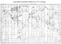
Doppler satellite ground stations providing data for WGS 72 development


All content from Kiddle encyclopedia articles (including the article images and facts) can be freely used under Attribution-ShareAlike license, unless stated otherwise. Cite this article:
World Geodetic System Facts for Kids. Kiddle Encyclopedia.