
Navigation facts for kids

Navigation is the art and science of figuring out where you are and how to get where you want to go.
Contents
Imagine trying to find your way to a friend's house without any directions or a map. You might get lost! Navigation helps us avoid getting lost, whether we're traveling by land, sea, or air. It allows us to:
- Travel safely: Knowing where we are and where we're going helps us avoid dangers like storms, rough terrain, or getting lost in the wilderness.
- Reach our destinations: Navigation ensures we arrive at the right place, whether it's a faraway country or just the local park.
- Explore new places: With good navigation skills, we can confidently explore new environments and discover exciting things.
- Trade and connect: Throughout history, navigation has allowed people to travel to different lands, trade goods, and connect with other cultures.
History

People have been navigating for thousands of years! Let's take a trip back in time to see how navigation has evolved:
Ancient times (before 500 AD)
Early humans relied on their senses and knowledge of the natural world to navigate. They observed the sun, moon, and stars to determine direction. They also used landmarks like mountains, rivers, and coastlines to guide their way.
- Polynesian Navigators: The Polynesians were some of the most skilled navigators of the ancient world. They explored and settled islands across the Pacific Ocean using only their knowledge of the stars, waves, and bird flight patterns. They created "stick charts" made of reeds and shells to represent ocean swells and island locations.
- The Egyptians: The Egyptians used the Nile River as a major transportation route. They developed basic surveying techniques to map the river and its surrounding lands.
Middle ages (500 AD - 1500 AD)
During this period, new tools and techniques were developed that made navigation more accurate.
- The Compass: The compass, invented in China and later adopted by Europeans, was a game-changer. It allowed sailors to determine direction even when the sun and stars weren't visible. The earliest compasses were made of lodestone, a naturally magnetic rock.
- The Astrolabe: The astrolabe was an instrument used to measure the altitude of the sun or stars. This information could be used to determine latitude, which is your distance north or south of the equator.
Age of exploration (1500 AD - 1800 AD)
This was a time of great exploration and discovery, as Europeans sailed to new lands around the world.
- The Sextant: The sextant was an improved version of the astrolabe. It allowed sailors to measure angles more accurately, leading to better latitude calculations.
- Accurate Maps: As explorers traveled to new places, they created more detailed and accurate maps. These maps helped future navigators plan their voyages. Gerardus Mercator, a famous cartographer, created a map projection that is still used today.
Modern era (1800 AD - Present)
In recent times, navigation has become even more precise and sophisticated with the development of new technologies.
- The Chronometer: The chronometer was a very accurate clock that could be used to determine longitude, which is your distance east or west of the Prime Meridian. John Harrison, an English clockmaker, invented the first successful chronometer in the 18th century.
- Radio Navigation: Radio signals were used to help ships and airplanes determine their position. Systems like LORAN (Long Range Navigation) used radio transmitters to provide navigational information.
- GPS (Global Positioning System): GPS is a satellite-based navigation system that allows users to determine their exact location anywhere on Earth. It uses a network of satellites orbiting the Earth to provide precise location data to GPS receivers.
Over the centuries, navigators have used a variety of tools to help them find their way. Here are some of the most important ones:
- Compass: A compass is an instrument that shows direction. It has a magnetic needle that aligns with the Earth's magnetic field, pointing towards magnetic north.
- Map: A map is a visual representation of an area, showing features like roads, rivers, and mountains. Maps help navigators plan their routes and identify landmarks.
- Chart: A chart is a special type of map used for navigation on water. It shows water depths, coastlines, and navigational hazards.
- GPS Receiver: A GPS receiver is a device that uses signals from GPS satellites to determine its location. GPS receivers are used in cars, airplanes, ships, and even smartphones.
- Sextant: An instrument used to measure the angle between a celestial body (like the sun or a star) and the horizon. This measurement can be used to determine latitude.
- Chronometer: A very accurate clock used to determine longitude.
Today, navigation is more advanced than ever before. Here's a look at how it works in different situations:
Land
When we're driving, hiking, or biking, we often use GPS devices or smartphone apps to navigate. These tools use GPS satellites to pinpoint our location and provide turn-by-turn directions. We can also use maps and compasses to navigate in areas where there's no GPS signal.
Sea
Sailors use a combination of GPS, charts, compasses, and radar to navigate. They also need to be aware of weather conditions, tides, and currents.
Air
Pilots rely on GPS, radio navigation systems, and radar to navigate airplanes. They also use maps and charts to plan their routes and avoid obstacles. Air traffic controllers help guide planes safely through the skies.
Space
Spacecraft use complex navigation systems to travel to other planets and explore the universe. These systems use sensors, computers, and communication with ground control to determine the spacecraft's position and trajectory.
Important terms
- Latitude: The distance north or south of the equator, measured in degrees. The equator is 0 degrees latitude, and the North and South Poles are 90 degrees latitude.
- Longitude: The distance east or west of the Prime Meridian, measured in degrees. The Prime Meridian is 0 degrees longitude and runs through Greenwich, England.
- Bearing: The direction of an object or landmark, measured in degrees from north.
- Course: The intended direction of travel.
- Speed: The rate at which an object is moving, usually measured in miles per hour (mph) or knots (nautical miles per hour).
- Distance: The length of a route or journey.
- The word navigation came from the word "navgatih" from the Sanskrit language.
- The Latin word navis means ship; navigation is literally "art of ship mastery".
- Many animals have amazing navigational abilities. Birds migrate thousands of miles each year, using the sun, stars, and Earth's magnetic field to guide them. Salmon return to the same rivers where they were born to spawn, using their sense of smell to find their way. Sea turtles migrate across entire oceans to lay their eggs on specific beaches.
Future
Navigation is constantly evolving. Scientists and engineers are working on new technologies that will make navigation even more accurate and efficient. Some of the exciting developments in the field include:
- Improved GPS: New generations of GPS satellites will provide even more accurate and reliable location data.
- Autonomous Vehicles: Self-driving cars, trucks, and ships will rely on advanced navigation systems to operate safely and efficiently.
- Indoor Navigation: New technologies are being developed to allow people to navigate indoors, using sensors and wireless networks.
- Space Exploration: Advanced navigation systems will be essential for future missions to the Moon, Mars, and beyond.
Navigation is a fascinating and important field that has shaped the course of history. From the ancient Polynesians to modern-day astronauts, people have always relied on navigation to explore the world and reach new frontiers. As technology continues to advance, navigation will play an even greater role in our lives.
Related pages
Images for kids
-
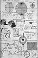
Table of geography, hydrography, and navigation, from the 1728 Cyclopaedia, or a Universal Dictionary of Arts and Sciences
-
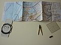
Manual navigation through Dutch airspace
-
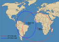
A celestial fix will be at the intersection of two or more circles.
-
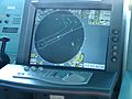
Radar ranges and bearings can be used to determine a position.


See also
 In Spanish: Navegación para niños
