Whitman County, Washington facts for kids
Quick facts for kids
Whitman County
|
|
|---|---|

|
|

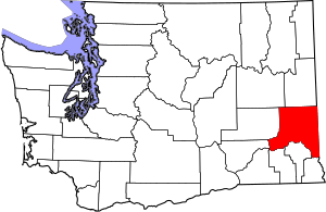
Location within the U.S. state of Washington
|
|
 Washington's location within the U.S. |
|
| Country | |
| State | |
| Founded | November 29, 1871 |
| Named for | Marcus Whitman |
| Seat | Colfax |
| Largest city | Pullman |
| Area | |
| • Total | 2,178 sq mi (5,640 km2) |
| • Land | 2,159 sq mi (5,590 km2) |
| • Water | 19 sq mi (50 km2) 0.9%% |
| Population
(2020)
|
|
| • Total | 47,973 |
| • Estimate
(2023)
|
48,012 |
| • Density | 22/sq mi (8/km2) |
| Time zone | UTC−8 (Pacific) |
| • Summer (DST) | UTC−7 (PDT) |
| Congressional district | 5th |
Whitman County is a county located in the U.S. state of Washington. As of the 2020 census, the population was 47,973. The county seat is Colfax, and its largest city is Pullman.
The county was formed from Stevens County in 1871. It is named after Marcus Whitman, a Presbyterian missionary who, with his wife Narcissa, was killed in 1847 by members of the Cayuse tribe.
Whitman County comprises the Pullman, Washington Metropolitan Statistical Area.
Contents
History
The area delineated by the future Washington state boundary began to be colonized at the start of the nineteenth century, both by Americans and Canadians. However, the majority of Canadian exploration and interest in the land was due to the fur trade, whereas American settlers were principally seeking land for agriculture and cattle raising. The Treaty of 1818 provided for dual control of this area by US and Canadian government officials. During this period, the future Washington Territory was divided into two administrative zones: Clark County and Lewis County (made official in 1845).
The dual-control concept was unwieldy and led to continual argument, and occasional conflict. The status of the Washington area was settled in 1846, when the Oregon Treaty ceded the land south of North latitude 49 degrees to American control.
In 1854, Skamania County was split from the original Clark County. Also in 1854, Walla Walla County was split from the new Skamania County. In 1863, Stevens County was split from Walla Walla County, and in 1871, a portion of Stevens County was set off to form Whitman County. The 1871 shape of Whitman County was considerably larger than its present boundary, as Adams, Franklin, and Lincoln counties were sectioned off from Whitman County in 1883. After that, Whitman County retained its shape, including through the period after Washington became the 42nd state of the Union in 1889.
Geography
According to the United States Census Bureau, the county has a total area of 2,178 square miles (5,640 km2), of which 2,159 square miles (5,590 km2) is land and 19 square miles (49 km2) (0.9%) is water. Whitman County is part of the Palouse, a wide and rolling prairie-like region of the middle Columbia basin.
Rivers
- Snake River
- Palouse River
- Latah Creek
- Union Flat Creek
- Rock Creek
- Pine Creek
Lakes and reservoirs
- Lake Herbert G. West, formed from Lower Monumental Dam
- Lake Bryan, named for Dr. Enoch A. Bryan, behind the Little Goose Dam
- Lower Granite Lake, behind the Lower Granite Dam
- Rock Lake
Summits and peaks
- Tekoa Mountain (elevation: 4009')
- Kamiak Butte (elevation: 3641')
- Steptoe Butte (elevation: 3612')
- Bald Butte (elevation: 3369)
Notable parks
- Steptoe Butte State Park
- Kamiak Butte County Park
- Palouse Falls State Park
- Central Ferry State Park
- Boyer Park and Marina
- Wawawai County Park
Adjacent counties
- Spokane County - north
- Benewah County, Idaho - northeast
- Latah County, Idaho - east
- Nez Perce County, Idaho - southeast
- Asotin County - south/southeast
- Garfield County - south
- Columbia County - south
- Franklin County - southwest
- Adams County - west
- Lincoln County - northwest
Major highways
Airports
- Pullman–Moscow Regional Airport: Airport with GA operations and a few airline flights with Alaska Airlines
- Port of Whitman Business Air Center Airport: Small GA Airport in Colfax
Demographics
| Historical population | |||
|---|---|---|---|
| Census | Pop. | %± | |
| 1880 | 7,014 | — | |
| 1890 | 19,109 | 172.4% | |
| 1900 | 25,360 | 32.7% | |
| 1910 | 33,280 | 31.2% | |
| 1920 | 31,323 | −5.9% | |
| 1930 | 28,014 | −10.6% | |
| 1940 | 27,221 | −2.8% | |
| 1950 | 32,469 | 19.3% | |
| 1960 | 31,263 | −3.7% | |
| 1970 | 37,900 | 21.2% | |
| 1980 | 40,103 | 5.8% | |
| 1990 | 38,775 | −3.3% | |
| 2000 | 40,740 | 5.1% | |
| 2010 | 44,776 | 9.9% | |
| 2020 | 47,973 | 7.1% | |
| 2023 (est.) | 48,012 | 7.2% | |
| U.S. Decennial Census 1790–1960 1900–1990 1990–2000 2010–2020 |
|||
2010 census
As of the 2010 census, there were 44,776 people, 17,468 households, and 8,130 families living in the county. The population density was 20.7 people per square mile (8.0 people/km2). There were 19,323 housing units at an average density of 8.9 units per square mile (3.4 units/km2). The racial makeup of the county was 84.6% white, 7.8% Asian, 1.7% black or African American, 0.7% American Indian, 0.2% Pacific islander, 1.4% from other races, and 3.6% from two or more races. Those of Hispanic or Latino origin made up 4.6% of the population. In terms of ancestry, 29.4% were German, 14.5% were English, 13.4% were Irish, 7.1% were Norwegian, and 4.1% were American.
Of the 17,468 households, 20.8% had children under the age of 18 living with them, 38.4% were married couples living together, 5.4% had a female householder with no husband present, 53.5% were non-families, and 32.7% of all households were made up of individuals. The average household size was 2.22 and the average family size was 2.86. The median age was 24.4 years.
The median income for a household in the county was $36,368 and the median income for a family was $61,598. Males had a median income of $46,663 versus $34,496 for females. The per capita income for the county was $19,506. About 10.7% of families and 27.6% of the population were below the poverty line, including 13.3% of those under age 18 and 5.7% of those age 65 or over.
Economy
Whitman County has highly productive agriculture. According to Heart of Washington, Whitman County produces more barley, wheat, dry peas, and lentils than any other county in the United States.
The county is also home to Schweitzer Engineering Laboratories in Pullman.
Education
Pullman is home to Washington State University, the state's land-grant university.
Communities
Cities
Towns
Census-designated place
Unincorporated communities
Ghost town
Gallery
Communities
Geography
-
Lower Granite Dam and Boyer Park and Marina on the Snake River
See also
 In Spanish: Condado de Whitman para niños


