White Township, New Jersey facts for kids
Quick facts for kids
White Township, New Jersey
|
|
|---|---|
|
Township
|
|

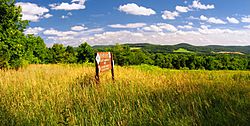
Beaver Brook Wildlife Management Area in White Township in July 2009
|
|

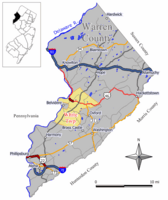
Location of White Township in Warren County highlighted in yellow (right). Inset map: Location of Warren County in New Jersey highlighted in black (left).
|
|

Census Bureau map of White Township, New Jersey
|
|
| Country | |
| State | |
| County | |
| Incorporated | April 9, 1913 |
| Named for | Alexander White |
| Government | |
| • Type | Township |
| • Body | Township Council |
| Area | |
| • Total | 27.90 sq mi (72.27 km2) |
| • Land | 27.37 sq mi (70.88 km2) |
| • Water | 0.54 sq mi (1.39 km2) 1.92% |
| Area rank | 97th of 565 in state 4th of 22 in county |
| Elevation | 525 ft (160 m) |
| Population
(2020)
|
|
| • Total | 4,606 |
| • Estimate
(2023)
|
4,704 |
| • Rank | 393rd of 565 in state 11th of 22 in county |
| • Density | 168.3/sq mi (65.0/km2) |
| • Density rank | 515th of 565 in state 16th of 22 in county |
| Time zone | UTC−05:00 (Eastern (EST)) |
| • Summer (DST) | UTC−04:00 (Eastern (EDT)) |
| ZIP Code |
07823 – Belvidere
|
| Area code(s) | 908 |
| FIPS code | 3404180570 |
| GNIS feature ID | 0882246 |
| Website | |
White Township is a township in Warren County, in the U.S. state of New Jersey. As of the 2020 United States census, the township's population was 4,606, a decrease of 276 (−5.7%) from the 2010 census count of 4,882, which in turn reflected an increase of 637 (+15.0%) from the 4,245 counted in the 2000 census.
White Township was incorporated as a township by an act of the New Jersey Legislature on April 9, 1913, from portions of Oxford Township, based on the results of a referendum held on May 1, 1913, making it the second-youngest township in the county. The township was named after Alexander White, who came to the area sometime before 1760 and built a stone mansion called "The White House" near a place called Roxburg.
Contents
Geography
According to the United States Census Bureau, the township had a total area of 27.90 square miles (72.27 km2), including 27.37 square miles (70.88 km2) of land and 0.54 square miles (1.39 km2) of water (1.92%). The township is located in the Kittatinny Valley which is a section of the Great Appalachian Valley that stretches for 700 miles (1,100 km) from Canada to Alabama.
Bridgeville (with a 2010 Census population of 106), Brookfield (675) and Buttzville (146) are census-designated places and unincorporated communities located within the township.
Other unincorporated communities, localities and place names located partially or completely within the township include Cornish, Foul Rift, Hazen, Little York, Manunka Chunk, Sarepta and Summerfield.
Mount No More is a mountain that is part of the New York–New Jersey Highlands of the Appalachian Mountains. The summit rises to 1,142 feet (348 m).
White Township borders the Warren County municipalities of Belvidere, Harmony Township, Hope Township, Knowlton Township, Liberty Township, Oxford Township and Washington Township.
Demographics
| Historical population | |||
|---|---|---|---|
| Census | Pop. | %± | |
| 1920 | 1,161 | — | |
| 1930 | 1,200 | 3.4% | |
| 1940 | 1,335 | 11.3% | |
| 1950 | 1,536 | 15.1% | |
| 1960 | 1,832 | 19.3% | |
| 1970 | 2,326 | 27.0% | |
| 1980 | 2,748 | 18.1% | |
| 1990 | 3,603 | 31.1% | |
| 2000 | 4,245 | 17.8% | |
| 2010 | 4,882 | 15.0% | |
| 2020 | 4,606 | −5.7% | |
| 2023 (est.) | 4,704 | −3.6% | |
| Population sources: 1920 1920–1930 1940–2000 2000 2010 2020 |
|||
The Township's economic data (as is all of Warren County) is calculated by the US Census Bureau as part of the Lehigh Valley / Allentown-Bethlehem-Easton, PA-NJ metropolitan statistical area.
2010 census
The 2010 United States census counted 4,882 people, 2,115 households, and 1,328 families in the township. The population density was 179.8 inhabitants per square mile (69.4/km2). There were 2,304 housing units at an average density of 84.9 per square mile (32.8/km2). The racial makeup was 95.33% (4,654) White, 2.03% (99) Black or African American, 0.08% (4) Native American, 0.76% (37) Asian, 0.02% (1) Pacific Islander, 0.78% (38) from other races, and 1.00% (49) from two or more races. Hispanic or Latino of any race were 2.74% (134) of the population.
Of the 2,115 households, 19.8% had children under the age of 18; 53.3% were married couples living together; 6.4% had a female householder with no husband present and 37.2% were non-families. Of all households, 33.5% were made up of individuals and 22.4% had someone living alone who was 65 years of age or older. The average household size was 2.23 and the average family size was 2.84.
17.0% of the population were under the age of 18, 6.4% from 18 to 24, 16.7% from 25 to 44, 31.0% from 45 to 64, and 28.9% who were 65 years of age or older. The median age was 50.9 years. For every 100 females, the population had 93.9 males. For every 100 females ages 18 and older there were 91.8 males.
The Census Bureau's 2006–2010 American Community Survey showed that (in 2010 inflation-adjusted dollars) median household income was $68,247 (with a margin of error of +/− $5,170) and the median family income was $81,975 (+/− $7,157). Males had a median income of $57,222 (+/− $15,520) versus $49,022 (+/− $7,746) for females. The per capita income for the borough was $36,964 (+/− $3,448). About 4.2% of families and 4.0% of the population were below the poverty line, including 2.4% of those under age 18 and 3.8% of those age 65 or over.
Education
The White Township School District serves public school students in pre-kindergarten through eighth grade at White Township Consolidated School. As of the 2021–22 school year, the district, comprised of one school, had an enrollment of 256 students and 32.1 classroom teachers (on an FTE basis), for a student–teacher ratio of 8.0:1.
Public school students in grades nine through twelve from Harmony Township, Hope Township and White Township attend Belvidere High School as part of sending/receiving relationships with the Belvidere School District. As of the 2021–22 school year, the high school had an enrollment of 357 students and 32.3 classroom teachers (on an FTE basis), for a student–teacher ratio of 11.1:1.
Students from the township and from all of Warren County are eligible to attend Ridge and Valley Charter School in Frelinghuysen Township (for grades K–8) or Warren County Technical School in Washington borough (for 9–12), with special education services provided by local districts supplemented throughout the county by the Warren County Special Services School District in Oxford Township (for Pre-K–12).
Transportation
As of May 2010[update], the township had a total of 66.08 miles (106.35 km) of roadways, of which 36.13 miles (58.15 km) were maintained by the municipality, 22.26 miles (35.82 km) by Warren County and 7.69 miles (12.38 km) by the New Jersey Department of Transportation.
U.S. Route 46 passes through the northern part of the township while Route 31 passes through briefly in the east before ending at Route 46. The major county road that passes through is CR 519.
Two limited access roads provide access to the municipality: Interstate 78/U.S. 22 in neighboring Franklin and Interstate 80 in neighboring Knowlton Township and Hope Township.
Landmarks and places of interest
Regular meetings of the Warren County Board of County Commissioners are held at the Wayne Dumont Jr. Administrative Building in White Township, which also houses most of the administrative offices of Warren County.
Part of the Pequest Fish Hatchery also lies within the boundaries of White Township.
Four Sisters Winery is located in White Township.
Notable people
People who were born in, residents of, or otherwise closely associated with White Township include:
- John Insley Blair (1802–1899), entrepreneur, railroad magnate, philanthropist and one of the 19th century's wealthiest men
- Charles W. Buttz (1837–1913), member of the United States House of Representatives from South Carolina
See also
 In Spanish: Municipio de White (Nueva Jersey) para niños


