Belvidere, New Jersey facts for kids
Quick facts for kids
Belvidere, New Jersey
|
||
|---|---|---|
|
Town
|
||

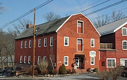
Twin mills in Belvidere Historic District
|
||
|
||

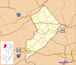
Location of Belvidere in Warren County highlighted in red (right). Inset map: Location of Warren County in New Jersey highlighted in orange (left).
|
||

Census Bureau map of Belvidere, New Jersey
|
||
| Country | ||
| State | ||
| County | ||
| Incorporated | April 7, 1845 | |
| Named for | Italian language "beautiful to see" | |
| Government | ||
| • Type | Town | |
| • Body | Town Council | |
| Area | ||
| • Total | 1.48 sq mi (3.84 km2) | |
| • Land | 1.45 sq mi (3.75 km2) | |
| • Water | 0.04 sq mi (0.09 km2) 2.36% | |
| Area rank | 452nd of 565 in state 22nd of 22 in county |
|
| Elevation | 266 ft (81 m) | |
| Population
(2020)
|
||
| • Total | 2,520 | |
| • Estimate
(2023)
|
2,536 | |
| • Rank | 467th of 565 in state 16th of 22 in county |
|
| • Density | 1,738.6/sq mi (671.3/km2) | |
| • Density rank | 316th of 565 in state 4th of 22 in county |
|
| Time zone | UTC−05:00 (Eastern (EST)) | |
| • Summer (DST) | UTC−04:00 (Eastern (EDT)) | |
| ZIP Code |
07823
|
|
| Area codes | 908 | |
| FIPS code | 3404104990 | |
| GNIS feature ID | 885156 | |
Belvidere is a town and the county seat of Warren County, in the U.S. state of New Jersey. As of the 2020 United States census, the town's population was 2,520, a decrease of 161 (−6.0%) from the 2010 census count of 2,681, which in turn reflected a decline of 90 (−3.2%) from the 2,771 counted in the 2000 census.
Belvidere was incorporated as a town by an act of the New Jersey Legislature on April 7, 1845, from portions of Oxford Township, based on the results of a referendum held that day. The town's name means "beautiful to see" in Italian.
Contents
Geography and climate
According to the U.S. Census Bureau, the town had a total area of 1.48 square miles (3.84 km2), including 1.45 square miles (3.75 km2) of land and 0.04 square miles (0.09 km2) of water (2.36%). Dildine Island is located in the Delaware River, approximately 4 miles (6.4 km) north of Belvidere.
Belvidere borders White Township in Warren County and Northampton County in Pennsylvania across the Delaware River.
| Climate data for Belvidere, New Jersey (1991–2020 normals, extremes 1893–present) | |||||||||||||
|---|---|---|---|---|---|---|---|---|---|---|---|---|---|
| Month | Jan | Feb | Mar | Apr | May | Jun | Jul | Aug | Sep | Oct | Nov | Dec | Year |
| Record high °F (°C) | 69 (21) |
77 (25) |
87 (31) |
96 (36) |
100 (38) |
103 (39) |
106 (41) |
103 (39) |
104 (40) |
94 (34) |
81 (27) |
73 (23) |
106 (41) |
| Mean maximum °F (°C) | 58.2 (14.6) |
59.8 (15.4) |
68.5 (20.3) |
81.2 (27.3) |
87.8 (31.0) |
91.3 (32.9) |
93.9 (34.4) |
92.3 (33.5) |
88.8 (31.6) |
80.2 (26.8) |
71.2 (21.8) |
60.0 (15.6) |
95.2 (35.1) |
| Mean daily maximum °F (°C) | 36.5 (2.5) |
39.8 (4.3) |
48.1 (8.9) |
60.6 (15.9) |
70.9 (21.6) |
79.3 (26.3) |
84.1 (28.9) |
82.6 (28.1) |
76.3 (24.6) |
64.2 (17.9) |
52.4 (11.3) |
41.4 (5.2) |
61.3 (16.3) |
| Daily mean °F (°C) | 27.3 (−2.6) |
29.2 (−1.6) |
37.0 (2.8) |
48.3 (9.1) |
58.5 (14.7) |
67.4 (19.7) |
72.3 (22.4) |
71.0 (21.7) |
64.1 (17.8) |
52.3 (11.3) |
41.3 (5.2) |
32.5 (0.3) |
50.1 (10.1) |
| Mean daily minimum °F (°C) | 18.0 (−7.8) |
18.6 (−7.4) |
25.9 (−3.4) |
36.1 (2.3) |
46.0 (7.8) |
55.5 (13.1) |
60.5 (15.8) |
59.4 (15.2) |
51.9 (11.1) |
40.3 (4.6) |
30.2 (−1.0) |
23.6 (−4.7) |
38.8 (3.8) |
| Mean minimum °F (°C) | 3.4 (−15.9) |
5.6 (−14.7) |
14.5 (−9.7) |
25.3 (−3.7) |
33.2 (0.7) |
43.9 (6.6) |
52.4 (11.3) |
50.3 (10.2) |
40.1 (4.5) |
28.8 (−1.8) |
18.3 (−7.6) |
11.2 (−11.6) |
1.6 (−16.9) |
| Record low °F (°C) | −20 (−29) |
−15 (−26) |
−5 (−21) |
9 (−13) |
27 (−3) |
31 (−1) |
42 (6) |
40 (4) |
28 (−2) |
18 (−8) |
1 (−17) |
−14 (−26) |
−20 (−29) |
| Average precipitation inches (mm) | 3.22 (82) |
2.72 (69) |
3.63 (92) |
3.95 (100) |
4.08 (104) |
4.48 (114) |
4.81 (122) |
4.55 (116) |
4.63 (118) |
4.75 (121) |
3.31 (84) |
4.08 (104) |
48.21 (1,225) |
| Average snowfall inches (cm) | 9.9 (25) |
5.2 (13) |
3.5 (8.9) |
0.3 (0.76) |
0.0 (0.0) |
0.0 (0.0) |
0.0 (0.0) |
0.0 (0.0) |
0.0 (0.0) |
0.0 (0.0) |
0.4 (1.0) |
4.0 (10) |
23.3 (59) |
| Average precipitation days (≥ 0.01 in) | 10.6 | 8.8 | 10.7 | 11.1 | 13.7 | 12.0 | 11.3 | 11.1 | 9.0 | 10.4 | 9.8 | 12.0 | 130.5 |
| Average snowy days (≥ 0.1 in) | 3.8 | 2.6 | 1.6 | 0.1 | 0.0 | 0.0 | 0.0 | 0.0 | 0.0 | 0.0 | 0.2 | 2.1 | 10.4 |
| Source: NOAA | |||||||||||||
Demographics
| Historical population | |||
|---|---|---|---|
| Census | Pop. | %± | |
| 1850 | 1,001 | — | |
| 1860 | 1,530 | 52.8% | |
| 1870 | 1,882 | 23.0% | |
| 1880 | 1,773 | −5.8% | |
| 1890 | 1,768 | −0.3% | |
| 1900 | 1,784 | 0.9% | |
| 1910 | 1,764 | −1.1% | |
| 1920 | 1,793 | 1.6% | |
| 1930 | 2,073 | 15.6% | |
| 1940 | 2,060 | −0.6% | |
| 1950 | 2,406 | 16.8% | |
| 1960 | 2,636 | 9.6% | |
| 1970 | 2,722 | 3.3% | |
| 1980 | 2,475 | −9.1% | |
| 1990 | 2,669 | 7.8% | |
| 2000 | 2,771 | 3.8% | |
| 2010 | 2,681 | −3.2% | |
| 2020 | 2,520 | −6.0% | |
| 2023 (est.) | 2,536 | −5.4% | |
| Population sources: 1850–1920 1850–1870 1850 1870 1880–1890 1890–1910 1910–1930 1940–2000 2010 2020 |
|||
2010 census
The 2010 United States census counted 2,681 people, 1,054 households, and 682 families in the town. The population density was 1,847.0 inhabitants per square mile (713.1/km2). There were 1,140 housing units at an average density of 785.4 per square mile (303.2/km2). The racial makeup was 96.01% (2,574) White, 1.57% (42) Black or African American, 0.11% (3) Native American, 0.78% (21) Asian, 0.00% (0) Pacific Islander, 0.22% (6) from other races, and 1.31% (35) from two or more races. Hispanic or Latino of any race were 3.62% (97) of the population.
Of the 1,054 households, 30.8% had children under the age of 18; 48.8% were married couples living together; 12.3% had a female householder with no husband present and 35.3% were non-families. Of all households, 28.7% were made up of individuals and 10.6% had someone living alone who was 65 years of age or older. The average household size was 2.52 and the average family size was 3.17.
25.3% of the population were under the age of 18, 8.2% from 18 to 24, 23.4% from 25 to 44, 30.6% from 45 to 64, and 12.4% who were 65 years of age or older. The median age was 41.0 years. For every 100 females, the population had 93.0 males. For every 100 females ages 18 and older there were 88.5 males.
The Census Bureau's 2006–2010 American Community Survey showed that (in 2010 inflation-adjusted dollars) median household income was $60,707 (with a margin of error of +/− $10,476) and the median family income was $74,028 (+/− $13,366). Males had a median income of $53,796 (+/− $11,432) versus $32,000 (+/− $7,359) for females. The per capita income for the town was $28,220 (+/− $2,359). About 0.8% of families and 2.3% of the population were below the poverty line, including none of those under age 18 and 2.9% of those age 65 or over.
Economy
A large site of DSM-Firmenich Nutritional Products that includes 250,000 square feet (23,000 m2) of facilities in the town, manufacturing products including arachidonic acid and beta-carotene by fermentation processes, is located on the town's border with White Township.
Education
The Belvidere School District serves students in pre-kindergarten through twelfth grade. As of the 2020–21 school year, the district, comprised of two schools, had an enrollment of 631 students and 61.5 classroom teachers (on an FTE basis), for a student–teacher ratio of 10.3:1. Schools in the district (with 2020–21 enrollment data from the National Center for Education Statistics) are Oxford Street Elementary School with 262 students in grades PreK-8, and Belvidere High School with 367 students in grades 9-12. As part of a cost-saving measure, Third Street School was closed after the 2018–2019 school year and merged into Oxford Street Elementary School. Students from Harmony Township, Hope Township and White Township attend the district's high school as part of sending/receiving relationships with the respective districts.
Students from the town and from all of Warren County are eligible to attend Ridge and Valley Charter School in Blairstown (for grades K–8) or Warren County Technical School in Washington borough (for 9–12), with special education services provided by local districts supplemented throughout the county by the Warren County Special Services School District in Oxford Township (for Pre-K–12).
Transportation
As of May 2010[update], the town had a total of 16.39 miles (26.38 km) of roadways, of which 14.38 miles (23.14 km) were maintained by the municipality and 2.01 miles (3.23 km) by Warren County.
The most prominent highway is County Route 620.
The Riverton–Belvidere Bridge crosses the Delaware River, connecting Belvidere with Riverton, Pennsylvania, operated by the Delaware River Joint Toll Bridge Commission. There is no toll for crossing on either side, after tolls were abolished by the Joint Commission for the Elimination of Toll Bridges in 1929. The bridge is 653 feet (199 m) long, connecting County Route 620 Spur (Water Street) in Belvidere to former Pennsylvania Route 709 on the Riverton side.
Notable people
People who were born in, residents of, or otherwise closely associated with Belvidere include:
- Donald J. Albanese (born 1937), politician who served in the New Jersey General Assembly from 1976 to 1982
- C. Ledyard Blair (1867–1949), investment banker and yachtsman
- DeWitt Clinton Blair (1833–1915), philanthropist and industrialist
- Charles W. Buttz (1837–1913), member of the United States House of Representatives from South Carolina
- Dan Gray (born 1956), former NFL defensive tackle who played for the Detroit Lions in 1978
- Henry S. Harris (1850–1902), former U.S. Member of Congress
- Don Hume (born 1938), former NASCAR driver who competed in 15 Winston Cup events
- Joseph Johnson (1785–1877), former member of Congress and Governor of Virginia
- John Patterson Bryan Maxwell (1804–1845), politician who represented New Jersey in the United States House of Representatives from 1837 to 1839 and again from 1841 to 1843
- William McMurtrie (1851–1913), chemist who served as president of the American Chemical Society
- Don Reitz (1929–2014), ceramic artist, recognized for inspiring a reemergence of salt glaze pottery in the United States
- Ernest Schelling (1876–1939), pianist, composer, conductor and music director who was the conductor of the Baltimore Symphony Orchestra from 1935 to 1937
- Melville Amasa Scovell (1855–1912), chemist
- George W. Scranton (1811–1861), former member of Congress and founder of the city of Scranton
- Chris Wylde (born 1976), actor and comedian
Places of interest
- Belvidere Cemetery – Dating back to 1834, the cemetery is the burial site of several historical figures, many associated with the Civil War, and has been included in tours conducted as part of the town's annual Victorian Days celebration.
- Foul Rift is a Class II rapids on the Delaware River located south of Belvidere, in which a drop of 22 feet (6.7 m) in elevation in a span of 0.5 miles (0.80 km) creates one of the river's most dangerous stretches.
- Four Sisters Winery – Established in 1984, the winery was named for the four daughters of the founders.
- Robert Morris House – Built by Robert Morris, a signer of the Declaration of Independence, the house is one of the town's oldest homes.
- Warren County Courthouse – Future New Jersey governor-elect Garret D. Wall (who declined to serve as governor after being elected in 1829) donated the land in 1825 and the courthouse was completed in 1826 at a cost of $10,000. In 1892, the courthouse was the site of the county's most recent public hanging.
- Warren County Museum – Now the home of the Warren County Historical and Genealogical Society, the museum is located on Garret D. Wall county square in a townhome constructed c. 1848 and purchased in 1980, which houses many items related to the history of Warren County.
See also
 In Spanish: Belvidere (Nueva Jersey) para niños


