
Waynetown, Indiana facts for kids
Quick facts for kids
Waynetown, Indiana
|
|
|---|---|
 |
|

Waynetown, Indiana
Location in Montgomery County, Indiana
|
|
| Country | United States |
| State | Indiana |
| County | Montgomery |
| Township | Wayne |
| Area | |
| • Total | 0.45 sq mi (1.15 km2) |
| • Land | 0.45 sq mi (1.15 km2) |
| • Water | 0.00 sq mi (0.00 km2) |
| Elevation | 755 ft (230 m) |
| Population
(2020)
|
|
| • Total | 960 |
| • Density | 2,157.30/sq mi (833.00/km2) |
| Time zone | UTC-5 (Eastern (EST)) |
| • Summer (DST) | UTC-4 (EDT) |
| ZIP code |
47990
|
| Area code(s) | 765 |
| FIPS code | 18-82052 |
| GNIS feature ID | 2397727 |
Waynetown is a town in Wayne Township, Montgomery County, in the U.S. state of Indiana. The population was 960 at the 2020 census.
Contents
History
Waynetown was platted as "Middletown" by Samuel Mann in 1830.
Geography
Waynetown is located in western Montgomery County. U.S. Route 136 passes through the center of town as Washington Street, leading east-southeast 9 miles (14 km) to Crawfordsville, the county seat, and west-northwest 11 miles (18 km) to Veedersburg. Indiana State Road 25 joins US 136 through the center of Waynetown but leads north 6 miles (10 km) to Wingate and south 4 miles (6 km) to its terminus at State Road 32.
According to the U.S. Census Bureau, Waynetown has a total area of 0.45 square miles (1.17 km2), all land. The East Fork of Coal Creek runs through the town, flowing west to Coal Creek and then southwest to the Wabash River at Cayuga.
Demographics
| Historical population | |||
|---|---|---|---|
| Census | Pop. | %± | |
| 1880 | 569 | — | |
| 1890 | 576 | 1.2% | |
| 1900 | 757 | 31.4% | |
| 1910 | 734 | −3.0% | |
| 1920 | 691 | −5.9% | |
| 1930 | 664 | −3.9% | |
| 1940 | 644 | −3.0% | |
| 1950 | 658 | 2.2% | |
| 1960 | 933 | 41.8% | |
| 1970 | 993 | 6.4% | |
| 1980 | 915 | −7.9% | |
| 1990 | 911 | −0.4% | |
| 2000 | 909 | −0.2% | |
| 2010 | 958 | 5.4% | |
| 2020 | 960 | 0.2% | |
| U.S. Decennial Census | |||
2010 census
As of the census of 2010, there were 1007 people, 391 households, and 282 families living in the town. The population density was 1,995.8 inhabitants per square mile (770.6/km2). There were 436 housing units at an average density of 908.3 per square mile (350.7/km2). The racial makeup of the town was 98.3% White, 0.2% African American, 0.4% from other races, and 1.0% from two or more races. Hispanic or Latino of any race were 2.0% of the population.
There were 391 households, of which 36.8% had children under the age of 18 living with them, 54.0% were married couples living together, 12.0% had a female householder with no husband present, 6.1% had a male householder with no wife present, and 27.9% were non-families. 24.8% of all households were made up of individuals, and 9.5% had someone living alone who was 65 years of age or older. The average household size was 2.45 and the average family size was 2.88.
The median age in the town was 37.1 years. 26.6% of residents were under the age of 18; 8.4% were between the ages of 18 and 24; 24.4% were from 25 to 44; 25.2% were from 45 to 64; and 15.4% were 65 years of age or older. The gender makeup of the town was 48.4% male and 51.6% female.
Local festivities
Each year the town of Waynetown holds a "Fish Fry" which also runs a carnival. The Fish Fry brings in many across the county, as well as from surrounding counties such as Fountain, Tippecanoe, and Parke.
Connection to Lewis & Clark Expedition
William Bratton (1778-1841), a member of the Lewis and Clark Expedition, settled in the Waynetown area in 1822 and "held various local county and township offices, including Justice of the Peace." He is buried in the Old Pioneer Cemetery within Waynetown.
Education
North Montgomery School Corporation serves Waynetown. Elementary students are zoned to Sommer Elementary School. Secondary school students attend Northridge Middle School and North Montgomery High School.
Gallery
-
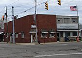
Red brick building is now a Native American Culture Museum and the lighter brick building is the post office
-
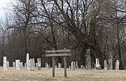
1830 Pioneer Cemetery
-
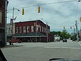
Hudson's Grocery


See also
 In Spanish: Waynetown (Indiana) para niños
