Cayuga, Indiana facts for kids
Quick facts for kids
Cayuga, Indiana
|
|
|---|---|

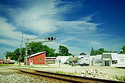
Businesses along Patterson Street
|
|

Location of Cayuga in Vermillion County, Indiana.
|
|

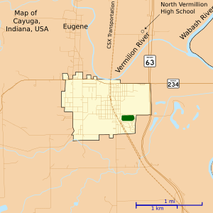
Map of Cayuga
|
|
| Country | United States |
| State | Indiana |
| County | Vermillion |
| Township | Eugene |
| Established | 1827 |
| Area | |
| • Total | 1.01 sq mi (2.62 km2) |
| • Land | 1.01 sq mi (2.62 km2) |
| • Water | 0.00 sq mi (0.00 km2) |
| Elevation | 505 ft (154 m) |
| Population
(2020)
|
|
| • Total | 952 |
| • Density | 939.78/sq mi (362.69/km2) |
| Time zone | UTC-5 (EST) |
| • Summer (DST) | UTC-5 (EST) |
| ZIP code |
47928
|
| Area code(s) | 765 |
| FIPS code | 18-10954 |
| GNIS feature ID | 432255 |
Cayuga is a town in Eugene Township, Vermillion County, in the U.S. state of Indiana. The population was 1,162 at the 2010 census.
Contents
History
When the town was laid out on September 20, 1827, it was called Eugene Station, though it was also called Osonimon after an Indian chief of that name. It was later renamed after the village of Cayuga and Cayuga Lake in the state of New York; an early settler named John Groenendyke had originally come from Cayuga County, New York, and moved to Vigo County in 1818, then in 1819 moved to the area that later became Vermillion County. The name is based on the Iroquois term Gwa-u-geh, meaning "the place of taking out" (in terms of a portage). Local legend attributes the name to the sound made by the horn of a Ford Model T. The town was incorporated around 1891.
The Cayuga post office has been in operation since 1886.
Geography
Cayuga is located at the intersection of Indiana State Road 63 and Indiana State Road 234, in the northern half of the county, near the confluence of the Vermillion and Wabash rivers.
According to the 2010 census, Cayuga has a total area of 1.01 square miles (2.62 km2), all land.
Demographics
| Historical population | |||
|---|---|---|---|
| Census | Pop. | %± | |
| 1900 | 832 | — | |
| 1910 | 911 | 9.5% | |
| 1920 | 933 | 2.4% | |
| 1930 | 968 | 3.8% | |
| 1940 | 1,126 | 16.3% | |
| 1950 | 1,022 | −9.2% | |
| 1960 | 904 | −11.5% | |
| 1970 | 1,090 | 20.6% | |
| 1980 | 1,258 | 15.4% | |
| 1990 | 1,083 | −13.9% | |
| 2000 | 1,109 | 2.4% | |
| 2010 | 1,162 | 4.8% | |
| 2020 | 952 | −18.1% | |
| U.S. Decennial Census | |||
2010 census
As of the census of 2010, there were 1,162 people, 475 households, and 329 families living in the town. The population density was 1,150.5 inhabitants per square mile (444.2/km2). There were 523 housing units at an average density of 517.8 per square mile (199.9/km2). The racial makeup of the town was 97.8% White, 0.2% African American, 0.5% Native American, 0.1% Asian, 0.3% from other races, and 1.2% from two or more races. Hispanic or Latino of any race were 0.5% of the population.
There were 475 households, of which 29.9% had children under the age of 18 living with them, 50.5% were married couples living together, 13.7% had a female householder with no husband present, 5.1% had a male householder with no wife present, and 30.7% were non-families. 26.7% of all households were made up of individuals, and 14.9% had someone living alone who was 65 years of age or older. The average household size was 2.45 and the average family size was 2.89.
The median age in the town was 43.2 years. 22.5% of residents were under the age of 18; 8.4% were between the ages of 18 and 24; 21.4% were from 25 to 44; 30.1% were from 45 to 64; and 17.6% were 65 years of age or older. The gender makeup of the town was 48.2% male and 51.8% female.
Industry
- Cayuga Generating Station
- Colonial Brick Corporation
See also
 In Spanish: Cayuga (Indiana) para niños

