Warren County, Virginia facts for kids
Quick facts for kids
Warren County
|
|||||
|---|---|---|---|---|---|

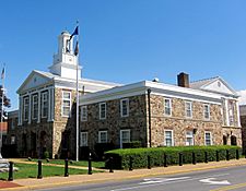
Warren County Courthouse in Front Royal, Virginia
|
|||||
|
|||||

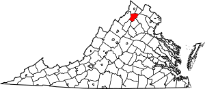
Location within the U.S. state of Virginia
|
|||||
 Virginia's location within the U.S. |
|||||
| Country | |||||
| State | |||||
| Founded | 1836 | ||||
| Named for | Joseph Warren | ||||
| Seat | Front Royal | ||||
| Largest town | Front Royal | ||||
| Area | |||||
| • Total | 217 sq mi (560 km2) | ||||
| • Land | 213 sq mi (550 km2) | ||||
| • Water | 3.3 sq mi (9 km2) 1.5% | ||||
| Population
(2020)
|
|||||
| • Total | 40,727 | ||||
| • Density | 187.7/sq mi (72.46/km2) | ||||
| Time zone | UTC−5 (Eastern) | ||||
| • Summer (DST) | UTC−4 (EDT) | ||||
| Congressional district | 6th | ||||
Warren County is a U.S. county located in the Commonwealth of Virginia. The 2020 census places Warren County within the Washington-Arlington-Alexandria, DC-VA-MD-WV Metropolitan Statistical Area with a population of 40,727. The county was established in 1836. The county seat is Front Royal.
Contents
History
By 1672, the entire Shenandoah Valley was claimed for hunting by the Iroquois Confederation following the Beaver Wars. Some bands of the Shawnee settled in the area as client groups to the Iroquois and alternately to the Cherokee after 1721. The Iroquois formally sold their entire claim east of the Alleghenies to the Virginia Colony at the Treaty of Lancaster in 1744. Warren County was established in 1836 from Frederick and Shenandoah Counties. At that time the county had a population of 7,000 people, a quarter of which were enslaved. Wedding records show marriages of people born in the 1770s marrying in the 1800s who head households of four to eight "free colored" so the early demographics of the population are unclear. Joist Hite lead the Sixteen Families into the Lower Shenandoah Valley. Some consider that group the first European settlers of the area, others believe different claims. Either way, Presbyterians of Scotch-Irish lineage and Quakers followed.
Rail service was established in 1854 with the construction of the Alexandria, Orange and Manassas Gap Railroad between Manassas and Riverton. This line was soon extended to Strasburg in time to become a factor in the Battle of Front Royal on May 23, 1862, and throughout the Civil War. Lumber, agriculture, manufacturing and grain mills provided employment in the region for decades after the Civil War. The county is named for Joseph Warren. During the Civil War the Battle of Front Royal took place in the county on May 23, 1862. On September 23, 1864, William Thomas Overby and five others of then Lt. Col. John S. Mosby's 43rd Virginia Battalion of Partisan Rangers were captured by cavalry troops under the command of then Brig. Gen. George A. Custer in Front Royal out of uniform and were executed as spies.
Geography
According to the U.S. Census Bureau, the county has a total area of 217 square miles (560 km2), of which 213 square miles (550 km2) is land and 3.3 square miles (8.5 km2) (1.5%) is water. The highest point is Hogback Mountain in Shenandoah National Park, along the border with Rappahannock County.
Adjacent counties
- Frederick County, Virginia – north
- Clarke County, Virginia – northeast
- Fauquier County, Virginia – east
- Rappahannock County, Virginia – southeast
- Page County, Virginia – southwest
- Shenandoah County, Virginia – west
National protected areas
- Cedar Creek and Belle Grove National Historical Park (part)
- George Washington National Forest (part)
- Shenandoah National Park (part)
Demographics
| Historical population | |||
|---|---|---|---|
| Census | Pop. | %± | |
| 1840 | 5,627 | — | |
| 1850 | 6,607 | 17.4% | |
| 1860 | 6,442 | −2.5% | |
| 1870 | 5,716 | −11.3% | |
| 1880 | 7,399 | 29.4% | |
| 1890 | 8,280 | 11.9% | |
| 1900 | 8,837 | 6.7% | |
| 1910 | 8,589 | −2.8% | |
| 1920 | 8,852 | 3.1% | |
| 1930 | 8,340 | −5.8% | |
| 1940 | 11,352 | 36.1% | |
| 1950 | 14,801 | 30.4% | |
| 1960 | 14,655 | −1.0% | |
| 1970 | 15,301 | 4.4% | |
| 1980 | 21,200 | 38.6% | |
| 1990 | 26,142 | 23.3% | |
| 2000 | 31,584 | 20.8% | |
| 2010 | 37,575 | 19.0% | |
| 2020 | 40,727 | 8.4% | |
| U.S. Decennial Census 1790–1960 1900–1990 1990–2000 2010 2020 |
|||
2020 census
| Race / Ethnicity | Pop 2010 | Pop 2020 | % 2010 | % 2020 |
|---|---|---|---|---|
| White alone (NH) | 33,345 | 33,831 | 88.74% | 83.07% |
| Black or African American alone (NH) | 1,709 | 1,722 | 4.55% | 4.23% |
| Native American or Alaska Native alone (NH) | 103 | 130 | 0.27% | 0.32% |
| Asian alone (NH) | 350 | 462 | 0.93% | 1.13% |
| Pacific Islander alone (NH) | 7 | 13 | 0.02% | 0.03% |
| Some Other Race alone (NH) | 35 | 255 | 0.09% | 0.63% |
| Mixed Race/Multi-Racial (NH) | 708 | 1,901 | 1.88% | 4.67% |
| Hispanic or Latino (any race) | 1,318 | 2,413 | 3.51% | 5.92% |
| Total | 37,575 | 40,727 | 100.00% | 100.00% |
Note: the US Census treats Hispanic/Latino as an ethnic category. This table excludes Latinos from the racial categories and assigns them to a separate category. Hispanics/Latinos can be of any race.
Economy
For many years, Avtex Fibers (formerly known as the American Viscose Corporation from 1910 to 1976), was the county's largest employer and taxpayer. At its height, it employed over 800 residents throughout Front Royal and Warren County.
Towards the late 1980s, however, the company's main plant in Front Royal was forced to close as a result of numerous environmental violations, which eventually resulted in the site being declared a Superfund site. The county, reeling from the sudden loss of jobs and tax revenue, established the Warren County Economic Development Authority (WCEDA) to stimulate and diversify its economy as well as the economy of Town of Front Royal, its county seat. The purpose of the WCEDA is to foster and stimulate industry and economic development within Warren County and the town of Front Royal.
Top employers
According to the county's comprehensive annual financial reports, the top employers by number of employees in the county are the following.
| Employer | Employees (2021) |
|---|---|
| Warren County School Board | 750–1,000 |
| Family Dollar Services | 250–499 |
| Valley Health System–WMH | 250–499 |
| Axalta Coating Systems (DuPont) | 250–499 |
| Walmart | 250–499 |
| Warren County Government | 250–499 |
| Sysco Northeast Redistribution | 250–499 |
| Randolph-Macon Academy | 250–499 |
| UPS Customer Center | 250–499 |
Transportation
- Front Royal Area Transit (FRAT) provides weekday transit for the town of Front Royal.
- Page County Transit - the People Movers provides weekday transit for the town of Luray and weekday service between Luray and Front Royal.
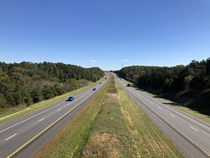
Major highways
 I-66
I-66 I-81
I-81 US 11
US 11 US 340
 US 522
 SR 55
SR 55 SR 79
SR 79- Skyline Drive
Education
College
- Christendom College
Public schools
- Skyline High School (9–12)
- Warren County High School (9–12)
- Warren County Middle School (6–8)
- Skyline Middle School (6–8)
- A.S. Rhodes Elementary School (K–5)
- E. Wilson Morrison Elementary School (K–5)
- Hilda J. Barbour Elementary School (PreK–5)
- Leslie Fox Keyser Elementary School (K–5)
- Ressie Jefferies Elementary School (K–5)
Preparatory school
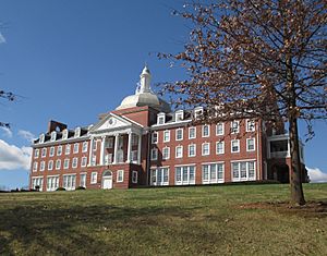
- Randolph-Macon Academy (6–12)
Communities
Town
- Front Royal (county seat)
Census-designated places
- Apple Mountain Lake
- Chester Gap (mostly in Rappahannock County)
- Shenandoah Farms
- Shenandoah Shores
- Skyland Estates
Other unincorporated communities
- Ashby
- Bentonville
- Bethel
- Browntown
- Buckton
- Cedarville
- Happy Creek
- Howellsville
- Karo
- Limeton
- Linden
- Milldale
- Nineveh
- Overall
- Reliance
- Riverton
- Rockland
- Waterlick
Notable people
- Thomas Ashby, born in Warren County, physician and Maryland state legislator
- Thomas M. Allen, born in Warren County, clergyman and university official in Missouri
See also
 In Spanish: Condado de Warren (Virginia) para niños


