Upper Township, New Jersey facts for kids
Quick facts for kids
Upper Township, New Jersey
|
||
|---|---|---|
|
Township
|
||
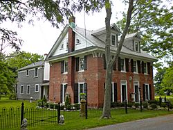
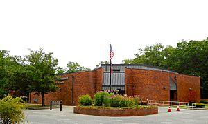
Marshallville Inn
|
||
|
||
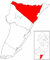
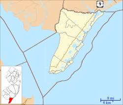
Location of Upper Township in Cape May County highlighted in red (left). Inset map: Location of Cape May County in New Jersey highlighted in red (right).
|
||
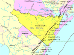
Census Bureau map of Upper Township, New Jersey
|
||
| Country | ||
| State | ||
| County | ||
| Formed | April 2, 1723 | |
| Incorporated | February 21, 1798 | |
| Government | ||
| • Type | Township | |
| • Body | Township Committee | |
| Area | ||
| • Total | 68.68 sq mi (177.89 km2) | |
| • Land | 62.03 sq mi (160.65 km2) | |
| • Water | 6.66 sq mi (17.24 km2) 9.69% | |
| Area rank | 17th of 565 in state 2nd of 16 in county |
|
| Elevation | 30 ft (9 m) | |
| Population
(2020)
|
||
| • Total | 12,539 | |
| • Estimate
(2023)
|
12,510 | |
| • Rank | 205th of 565 in state 3rd of 16 in county |
|
| • Density | 202.2/sq mi (78.1/km2) | |
| • Density rank | 502nd of 565 in state 15th of 16 in county |
|
| Time zone | UTC−05:00 (Eastern (EST)) | |
| • Summer (DST) | UTC−04:00 (Eastern (EDT)) | |
| ZIP Codes | ||
| Area code(s) | 609 | |
| FIPS code | 3400974810 | |
| GNIS feature ID | 0882047 | |
| Website | ||
Upper Township is a large township in Cape May County, in the U.S. state of New Jersey. The township, and all of Cape May County, is part of the South Jersey region of the state and of the Ocean City metropolitan statistical area, which is part of the Philadelphia-Wilmington-Camden, PA-NJ-DE-MD combined statistical area, also known as the Delaware Valley or Philadelphia metropolitan area. As of the 2020 United States census, the township's population was 12,539, an increase of 166 (+1.3%) from the 2010 census count of 12,373, which in turn reflected an increase of 258 (+2.1%) from the 12,115 counted in the 2000 census.
New Jersey Monthly magazine ranked Upper Township as its 2nd best place to live in its 2008 rankings of the "Best Places To Live" in New Jersey.
Upper Township is home to the only yellow fire trucks in Cape May County, a tradition started in 1985 when the Seaville Fire Rescue Company was purchasing a new vehicle and thought that federal regulations would require the color. Since being formed in 1964 and purchasing its first fire truck a year later, the Seaville company has served the area, responding to over 200 calls a year from its fire station is located on Route 50 across from Dino's Seaville Diner.
Contents
History
Upper Township was formed as a precinct on April 2, 1723, and was incorporated as one of New Jersey's initial 104 townships by an act of the New Jersey Legislature on February 21, 1798. Portions of the township have been taken to form Dennis Township (March 1, 1827) and Ocean City borough (March 3, 1884), and territorial changes were made involving Sea Isle City in March and April 1905. The township's name came from its location when Cape May was split into three townships in 1723 at the same time that Lower Township and Middle Township were created.
During 2008, Upper Township was considering consolidation with neighboring Corbin City. Corbin City already shares extensively with Upper Township for municipal service, but the question of consolidating municipalities across county borders presented an obstacle to a full merger.
Geography
According to the United States Census Bureau, the township had a total area of 68.68 square miles (177.89 km2), including 62.03 square miles (160.65 km2) of land and 6.66 square miles (17.24 km2) of water (9.69%).
Strathmere (2010 population of 158) is an unincorporated community and census-designated place (CDP) located within Upper Township.
Other unincorporated communities, localities and place names located partially or completely within the township include Beesley's Point, Blackmans Island, Cedar Springs, Corsons Inlet, Formosa, Greenfield, Marmora, Marshallville, Middletown, Miramar, Palermo, Petersburg, Seaville, Steelmantown, Tuckahoe, West Ocean City and Whale Beach. The township contains many different communities and enclaves that create a diverse area reaching from Great Egg Harbor to the Atlantic Ocean. Seaville is the largest community and Strathmere is the township's island containing a beach community.
The township borders the municipalities of Dennis Township, Ocean City, Sea Isle City and Woodbine in Cape May County; Corbin City, Egg Harbor Township, Estell Manor and Somers Point in Atlantic County; and Maurice River Township in Cumberland County.
Demographics
| Historical population | |||
|---|---|---|---|
| Census | Pop. | %± | |
| 1810 | 1,664 | — | |
| 1820 | 2,107 | 26.6% | |
| 1830 | 1,067 | * | −49.4% |
| 1840 | 1,217 | 14.1% | |
| 1850 | 1,341 | 10.2% | |
| 1860 | 1,552 | 15.7% | |
| 1870 | 1,483 | −4.4% | |
| 1880 | 1,702 | 14.8% | |
| 1890 | 1,381 | * | −18.9% |
| 1900 | 1,351 | −2.2% | |
| 1910 | 1,483 | 9.8% | |
| 1920 | 1,272 | −14.2% | |
| 1930 | 1,657 | 30.3% | |
| 1940 | 1,675 | 1.1% | |
| 1950 | 1,922 | 14.7% | |
| 1960 | 2,539 | 32.1% | |
| 1970 | 3,413 | 34.4% | |
| 1980 | 6,713 | 96.7% | |
| 1990 | 10,681 | 59.1% | |
| 2000 | 12,115 | 13.4% | |
| 2010 | 12,373 | 2.1% | |
| 2020 | 12,539 | 1.3% | |
| 2023 (est.) | 12,510 | 1.1% | |
| Population sources:1810–2000 1810–1920 1840 1850–1870 1850 1870 1880–1890 1890–1910 1910–1930 1940–2000 2000 2010 2020 * = Lost territory in previous decade. |
|||
2010 census
The 2010 United States census counted 12,373 people, 4,566 households, and 3,461 families in the township. The population density was 199.1 per square mile (76.9/km2). There were 6,341 housing units at an average density of 102.0 per square mile (39.4/km2). The racial makeup was 96.61% (11,954) White, 0.58% (72) Black or African American, 0.13% (16) Native American, 0.74% (92) Asian, 0.01% (1) Pacific Islander, 0.72% (89) from other races, and 1.20% (149) from two or more races. Hispanic or Latino of any race were 2.36% (292) of the population.
Of the 4,566 households, 32.6% had children under the age of 18; 62.2% were married couples living together; 9.7% had a female householder with no husband present and 24.2% were non-families. Of all households, 20.1% were made up of individuals and 9.4% had someone living alone who was 65 years of age or older. The average household size was 2.71 and the average family size was 3.14.
23.8% of the population were under the age of 18, 7.7% from 18 to 24, 20.2% from 25 to 44, 34.0% from 45 to 64, and 14.3% who were 65 years of age or older. The median age was 43.6 years. For every 100 females, the population had 94.4 males. For every 100 females ages 18 and older there were 92.1 males.
The Census Bureau's 2006-2010 American Community Survey showed that (in 2010 inflation-adjusted dollars) median household income was $81,250 (with a margin of error of +/− $8,629) and the median family income was $97,372 (+/− $6,832). Males had a median income of $63,597 (+/− $2,442) versus $46,250 (+/− $4,552) for females. The per capita income for the borough was $38,702 (+/− $2,243). About 2.5% of families and 4.0% of the population were below the poverty line, including 2.9% of those under age 18 and 6.6% of those age 65 or over.
Parks and recreation
With its beaches in the Strathmere section, Upper Township is one of five municipalities in the state that offer free public access to oceanfront beaches monitored by lifeguards, joining Atlantic City, North Wildwood, Wildwood and Wildwood Crest.
Education
The Upper Township School District serves students in pre-kindergarten through eighth grade. As of the 2021–22 school year, the district, comprised of three schools, had an enrollment of 1,404 students and 122.0 classroom teachers (on an FTE basis), for a student–teacher ratio of 11.5:1. Schools in the district (with 2021–22 enrollment data from the National Center for Education Statistics) are Upper Township Primary School with 497 students in grades PreK-2, Upper Township Elementary School with 408 students in grades 3-5 and Upper Township Middle School with 485 students in grades 6-8. Students from Corbin City, a non-operating school district, attend the Upper Township schools as part of a sending/receiving relationship.
Students in public school for ninth through twelfth grades from Upper Township attend Ocean City High School in Ocean City as part of a sending/receiving relationship with the Ocean City School District, along with students from Corbin City, Longport and Sea Isle City. As of the 2021–22 school year, the high school had an enrollment of 1,231 students and 126.4 classroom teachers (on an FTE basis), for a student–teacher ratio of 9.7:1. As of 2015[update] about 60% of students in Ocean City High School were from Upper Township.
Countywide schools include Cape May County Technical High School (for technical school students) and Cape May County Special Services School District (for special needs students) in Cape May Court House.
The Roman Catholic Diocese of Camden operates Bishop McHugh Regional School, a Catholic K-8 school, in Dennis Township, which has a Cape May Courthouse postal address. The Press of Atlantic City describes it as being in Ocean View, though it lies outside of the Ocean View CDP. It is the parish school of Marmora/Woodbine Catholic Church and three other churches.
Cape May County Library operates the Upper Township Branch in Petersburg.
Police Department
Upper Township does not maintain its own municipal police department. The township is served by the New Jersey State Police who respond from their barracks in neighboring Woodbine.
Transportation
Roads and highways
As of May 2010[update], the township had a total of 140.23 miles (225.68 km) of roadways, of which 74.84 miles (120.44 km) were maintained by the municipality, 36.95 miles (59.47 km) by Cape May County and 19.37 miles (31.17 km) by the New Jersey Department of Transportation and 9.07 miles (14.60 km) by the New Jersey Turnpike Authority.
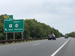
The Garden State Parkway and US 9 pass through the town and has two exits that provide access to Route 50 and U.S. Route 9, and they both corss over the Great Egg Harbor Bridge, since the Beesley's Point Bridge is closed. The Parkway connects Dennis Township on the south to Egg Harbor Township in the north. at Interchange 20 for Seaville / Tuckahoe and Interchange 25 for Ocean City / Marmora via County Route 623.
Other major roads that pass through include Route 49, CR 548 and CR 557.
Public transportation
NJ Transit offers the 313 and 315 (and the 316 offering seasonal service) inter-city bus routes that runs through the town three times a day and shuttle people between Cape May and Philadelphia, the 319 route between Cape May and the Port Authority Bus Terminal in Midtown Manhattan, and the 552 route between Cape May and Atlantic City.
Points of interest
- Tuckahoe station
- Marshallville Historic District
- Thomas Beesley Sr. House
- John Wesley Gandy House
Notable people
People who were born in, residents of, or otherwise closely associated with Upper Township include:
- George Gandy (1851–1946), business executive and developer, best known for constructing the original Gandy Bridge, the first bridge to span the Tampa Bay in Florida.
- Garet Garrett (1878–1954), journalist and author, noted for his opposition to the New Deal and U.S. involvement in World War II.
- Carlton Godfrey (1865–1929), politician and businessman who served in the New Jersey General Assembly for five years and was Speaker of the House in 1915.
- Ford Palmer (born 1990), professional middle-distance runner who specializes in the 1500 meters and the mile.
- Bob Pellegrini (1934–2008), linebacker who played in the National Football League for the Philadelphia Eagles and the Washington Redskins.
- Dummy Stephenson (1869–1924), outfielder in Major League Baseball who played for the Philadelphia Phillies in 1892.
- Adam Williamson (born 1984), professional soccer midfielder who has played for the Ocean City Barons in the USL Premier Development League.
See also
 In Spanish: Municipio de Upper (Nueva Jersey) para niños


