Tottori Prefecture facts for kids
Quick facts for kids Tottori Prefecture |
|||||||||
|
|||||||||
 |
|||||||||
| Capital | Tottori (city) | ||||||||
| Region | Chūgoku | ||||||||
| Island | Honshu | ||||||||
| Governor | Shinji Hirai | ||||||||
| Area (rank) | 3,507.19 km² (41st) | ||||||||
| - % water | 0.7% | ||||||||
| Population (April 1, 2011) | |||||||||
| - Population | 584,982 (47th) | ||||||||
| - Density | 166.89 /km² | ||||||||
| Districts | 5 | ||||||||
| Municipalities | 19 | ||||||||
| ISO 3166-2 | JP-31 | ||||||||
| Website | www.pref.tottori.jp/ english/ |
||||||||
| Prefectural Symbols | |||||||||
| - Flower | Nijisseiki nashi pear blossom (Pyrus pyrifolia) | ||||||||
| - Tree | Daisenkyaraboku (Taxus cuspidata) | ||||||||
| - Bird | Mandarin Duck (Aix galericulata) | ||||||||
| - Fish | {{{Fish}}} | ||||||||
 Symbol of Tottori Prefecture |
|||||||||
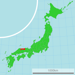
Tottori Prefecture (鳥取県, Tottori-ken) is a Japanese prefecture in the Chūgoku region of the island of Honshu. The capital is the city of Tottori. It is the least populous prefecture in Japan.
Contents
History
Before the Meiji Restoration, Tottori encompassed the old provinces of Hōki and Inaba.
Geography
The northern coastline of Tottori faces the Sea of Japan. Its eastern border meets Hyōgo Prefecture. The southern border meets Okayama Prefecture and Hiroshima Prefecture. The western border meets Shimane Prefecture.
Cities
Four cities are located in Tottori Prefecture:
- Kurayoshi
- Sakaiminato
- Tottori (capital)
- Yonago
National Parks
National Parks are established in about 14% of the total land area of the prefecture.
Shrines and Temples
Ubi jinjū and Shitori jinja are the chief Shinto shrines (ichinomiya) in the prefecture.
Related pages
- Provinces of Japan
- Prefectures of Japan
- List of regions of Japan
- List of islands of Japan
- Gainare Tottori
Images for kids
-
Sunaba Coffee House, a well known Coffeehouse in Tottori
-
Panoramic view of Mount Daisen, Yonago
See also
 In Spanish: Prefectura de Tottori para niños


