Talbot County, Georgia facts for kids
Quick facts for kids
Talbot County
|
|
|---|---|

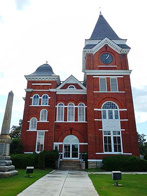
Talbot County Courthouse and Confederate Monument in Talbotton
|
|

Location within the U.S. state of Georgia
|
|
 Georgia's location within the U.S. |
|
| Country | |
| State | |
| Founded | December 14, 1827 |
| Named for | Matthew Talbot |
| Seat | Talbotton |
| Largest city | Talbotton |
| Area | |
| • Total | 395 sq mi (1,020 km2) |
| • Land | 391 sq mi (1,010 km2) |
| • Water | 3.4 sq mi (9 km2) 0.9%% |
| Population
(2020)
|
|
| • Total | 5,733 |
| • Density | 15/sq mi (6/km2) |
| Time zone | UTC−5 (Eastern) |
| • Summer (DST) | UTC−4 (EDT) |
| Congressional district | 2nd |
Talbot County is a county located in the west central portion of the U.S. state of Georgia. The 2020 census showed a population of 5,733. The county seat and largest city is Talbotton.
Contents
History
Talbot County was created from a portion of Muscogee County by a December 14, 1827, act of the Georgia General Assembly. It was named after the late Georgia governor Matthew Talbot. Taylor County was created from a portion of Talbot County in 1852.
Geography
According to the U.S. Census Bureau, the county has a total area of 395 square miles (1,020 km2), of which 391 square miles (1,010 km2) is land and 3.4 square miles (8.8 km2) (0.9%) is water.
The county straddles the fall line of the Eastern U.S., and thus northern areas of the county are hillier compared to southern areas of the county. The Fall Line Freeway runs across the southern portion of the county, following Georgia State Route 96 from Geneva to Junction City. The far northern portion of the county is part of the Pine Mountain Range, with elevations in this areas exceeding 1,000 ft on the highest peaks of the mountains.
The northeastern three-quarters of Talbot County is located in the Upper Flint River sub-basin of the Apalachicola-Chattahoochee-Flint River Basin. The southwestern quarter, west of Junction City, is located in the Middle Chattahoochee River-Walter F. George Lake sub-basin, while a narrow sliver of the western border, east of Waverly Hall, is located in the Middle Chattahoochee River-Lake Harding sub-basin.
Major highways
Adjacent counties
- Upson County - northeast
- Taylor County - southeast
- Marion County - south
- Chattahoochee County - southwest
- Muscogee County - west-southwest
- Harris County - west
- Meriwether County - north
Railroads
Communities
Cities
- Talbotton (county seat)
- Woodland
- Manchester (part)
Towns
Unincorporated communities
- Box Springs
- Centerville
- Po Biddy Crossroads
- Tax Crossroads
Demographics
| Historical population | |||
|---|---|---|---|
| Census | Pop. | %± | |
| 1830 | 5,940 | — | |
| 1840 | 15,627 | 163.1% | |
| 1850 | 16,534 | 5.8% | |
| 1860 | 13,616 | −17.6% | |
| 1870 | 11,913 | −12.5% | |
| 1880 | 14,115 | 18.5% | |
| 1890 | 13,258 | −6.1% | |
| 1900 | 12,197 | −8.0% | |
| 1910 | 11,696 | −4.1% | |
| 1920 | 11,158 | −4.6% | |
| 1930 | 8,458 | −24.2% | |
| 1940 | 8,141 | −3.7% | |
| 1950 | 7,687 | −5.6% | |
| 1960 | 7,127 | −7.3% | |
| 1970 | 6,625 | −7.0% | |
| 1980 | 6,536 | −1.3% | |
| 1990 | 6,524 | −0.2% | |
| 2000 | 6,498 | −0.4% | |
| 2010 | 6,865 | 5.6% | |
| 2020 | 5,733 | −16.5% | |
| 2023 (est.) | 5,718 | −16.7% | |
| U.S. Decennial Census 1790-1880 1890-1910 1920-1930 1930-1940 1940-1950 1960-1980 1980-2000 2010 2020 |
|||
| Race / Ethnicity (NH = Non-Hispanic) | Pop 2000 | Pop 2010 | Pop 2020 | % 2000 | % 2010 | % 2020 |
|---|---|---|---|---|---|---|
| White alone (NH) | 2,354 | 2,639 | 2,427 | 36.23% | 38.44% | 42.33% |
| Black or African American alone (NH) | 3,974 | 4,039 | 3,056 | 61.16% | 58.83% | 53.31% |
| Native American or Alaska Native alone (NH) | 14 | 18 | 5 | 0.22% | 0.26% | 0.09% |
| Asian alone (NH) | 18 | 9 | 17 | 0.28% | 0.13% | 0.30% |
| Pacific Islander alone (NH) | 1 | 0 | 1 | 0.02% | 0.00% | 0.02% |
| Other race alone (NH) | 3 | 3 | 6 | 0.05% | 0.04% | 0.10% |
| Mixed race or Multiracial (NH) | 52 | 66 | 109 | 0.80% | 0.96% | 1.90% |
| Hispanic or Latino (any race) | 82 | 91 | 112 | 1.26% | 1.33% | 1.95% |
| Total | 6,498 | 6,865 | 5,733 | 100.00% | 100.00% | 100.00% |
As of the 2020 United States census, there were 5,733 people, 2,809 households, and 1,849 families residing in the county.
Education
The Talbot County School District holds pre-school to grade twelve, and consists of one building with 48 full-time teachers and 792 students. The district headquarters is in Talbotton.
See also
 In Spanish: Condado de Talbot (Georgia) para niños

