Supervolcano facts for kids
-
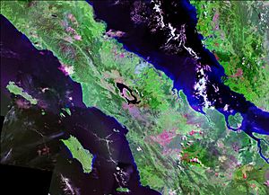
 Satellite image of Lake Toba, the site of a VEI 8 eruption c. 75,000 years ago.
A supervolcano is a volcano that can make a volcanic eruption where the things being thrown out of the volcano have a volume bigger than 1,000 km3 (240 cu mi). This is thousands of times bigger than most volcanic eruptions which happened a long time. Supervolcanoes can occur when magma in the Earth rises into the crust from a hotspot, but can not break through the crust. More and more pressure builds up in a large and growing magma pool until the crust can no longer take the pressure.
Although there are not many Quaternary supervolcanoes, supervolcanic eruptions usually cover very big areas with lava and volcanic ash. They can also cause a long-lasting change to weather (such as the triggering of a small ice age), enough to possibly make species extinct.

Contents
Terminology
The term "supervolcano" was first used in the BBC popular science television program Horizon in 2000 to mean eruptions of this type.
Volcanologists and geologists do not say "supervolcanoes" in their scientific work. This is because the word can mean many different geothermal conditions. Since 2003, however, the term has been used by professionals when showing things to the public. The term megacaldera is sometimes used for calderas which are quite similar to supervolcanoes, such as the Blake River Megacaldera Complex in the Abitibi greenstone belt of Ontario and Quebec, Canada.
Massive explosive eruptions
Volcanic eruptions are classified using the Volcanic Explosivity Index, or VEI. It is a logarithmic scale, which means that an increase of one in VEI number is equivalent to a tenfold increase in volume of erupted material. VEI 7 or VEI 8 eruptions are so powerful that they often form circular calderas rather than cones because the downward withdrawal of magma causes the overlying rock mass to collapse into the empty magma chamber beneath it.
Known super eruptions
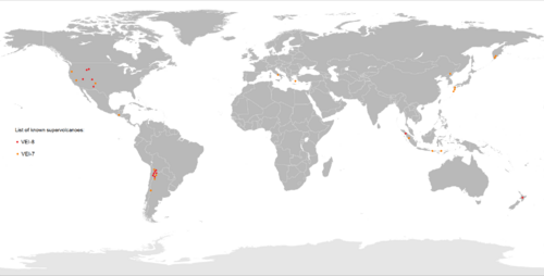
Based on incomplete statistics, at least 60 VEI 8 eruptions have been identified.
| Name | Zone | Location | Notes | Years ago (approx.) | Ejecta bulk volume (approx.) | Reference |
|---|---|---|---|---|---|---|
| Flat Landing Brook Formation | Tetagouche-Exploits back-arc basin | New Brunswick, Canada | May be a single supereruption of at least 12,000 km3 (VEI 9) or multiple 2,000+ km3 eruptions | 466,000,000 | 2,000–12,000 km3 | |
| Wah Wah Springs | Indian Peak–Caliente Caldera Complex | Utah, United States | The largest of the Indian Peak-Caliente Caldera Complex eruptions, preserved as the Wah Wah Springs Tuff; includes lava flows more than 4,000 metres (13,000 ft) thick | 30,600,000 | 5,500–5,900 km3 | |
| La Garita Caldera | San Juan volcanic field | Colorado, United States | Fish Canyon eruption | 27,800,000 | 5,000 km3 | |
| Lake Toba | Lake Toba, North Sumatra | Sumatra, Indonesia | Produced 2200–4400 million tons of H2SO4 | 74,000 | 2,800 km3 | |
| Atana Ignimbrite | Pacana Caldera | Antofagasta, Chile | Part of the Altiplano–Puna volcanic complex | 4,000,000 | 2,500 km3 | |
| Huckleberry Ridge eruption | Yellowstone hotspot | Idaho, United States | Huckleberry Ridge Tuff | 2,100,000 | 2,450–2,500 km3 | |
| Taupo Nui a tia | Taupo Volcanic Zone | North Island, New Zealand | Whakamaru Ignimbrite/Mount Curl Tephra | 340,000 | 2,000 km3 | |
| Heise Volcanic Field | Yellowstone hotspot | Idaho, United States | Kilgore Tuff | 4,500,000 | 1,800 km3 | |
| Heise Volcanic Field | Yellowstone hotspot | Idaho, United States | Blacktail Tuff | 6,000,000 | 1,500 km3 | |
| Cerro Guacha | Altiplano-Puna volcanic complex | Sur Lípez, Bolivia | Guacha ignimbrite, two smaller eruptions identified | 5,700,000 | 1,300 km3 | |
| Mangakino Caldera | Taupo Volcanic Zone | North Island, New Zealand | Kidnappers eruption | 1,080,000 | 1,200 km3 | |
| Oruanui eruption | Taupo Volcanic Zone | North Island, New Zealand | Taupo Volcano (Lake Taupo) | 26,500 | 1,170 km3 | |
| Cerro Galán | Andes Central Volcanic Zone | Catamarca, Argentina | 2,500,000 | 1,050 km3 | ||
| Lava Creek eruption | Yellowstone hotspot | Idaho, Montana, and Wyoming, United States | Lava Creek Tuff | 640,000 | 1,000 km3 |
Related pages
Images for kids
-
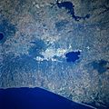
Satellite image of San Salvador, El Salvador and the Lake Ilopango caldera (also known as the Dark Age volcano) in the Valley of the Hammocks, site of a VEI 6-8 eruption and said to be ground zero for the extreme weather events of 535–536, when a dark veil settled on the world.
See also
 In Spanish: Supervolcán para niños


