Spring Valley, Wisconsin facts for kids
Quick facts for kids
Spring Valley, Wisconsin
|
|
|---|---|

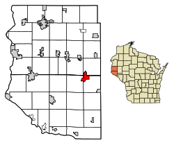
Location of Spring Valley in Pierce County
and St. Croix County, Wisconsin. |
|
| Country | |
| State | |
| Counties | Pierce, St. Croix |
| Area | |
| • Total | 4.33 sq mi (11.20 km2) |
| • Land | 3.97 sq mi (10.28 km2) |
| • Water | 0.36 sq mi (0.92 km2) |
| Elevation | 909 ft (277 m) |
| Population
(2020)
|
|
| • Total | 1,401 |
| • Density | 339.63/sq mi (131.13/km2) |
| Time zone | UTC-6 (Central (CST)) |
| • Summer (DST) | UTC-5 (CDT) |
| Area code(s) | 715 & 534 |
| FIPS code | 55-76300 |
| GNIS feature ID | 1574697 |
Spring Valley is a village in Pierce and St. Croix counties in Wisconsin, United States. The population was 1,401 at the 2020 census. Of those, 1,390 were in Pierce County and 11 in St. Croix County. The village is mostly within the Town of Spring Lake in Pierce County. Small parts also lie in the Town of Gilman, also in Pierce County, and the Town of Cady in St. Croix County.
Geography
Spring Valley is located at 44°50′50″N 92°14′24″W / 44.84722°N 92.24000°W (44.847111, -92.240130), along the Eau Galle River.
According to the United States Census Bureau, the village has an area of 4.54 square miles (11.76 km2), of which 4.14 square miles (10.72 km2) is land and 0.40 square miles (1.04 km2) is water.
Natural attractions
Crystal Cave is about a mile southwest of Spring Valley. This privately held natural attraction, formed millions of years ago by ground water eroding the sandstone and dolomite that underlies the area, has been open to tourists since 1942. A local 16-year-old discovered an opening to the cave in 1881. It was excavated, developed and promoted to the public by an Eau Claire, Wisconsin amateur geologist and advertising man. Opening day drew 4,000 visitors. The owners have retained the flavor of the 1950s and enjoy sharing the site's geologic history with visitors.
Promoted as the Midwest's largest earthen dam, Eau Galle Dam and Recreation, northwest of town, was built by the Army Corps of Engineers in 1965 to protect Spring Valley from the Eau Galle River's surging flood waters. A recreational area has grown up around the dam's reservoir, Lake George.
Demographics
| Historical population | |||
|---|---|---|---|
| Census | Pop. | %± | |
| 1900 | 1,021 | — | |
| 1910 | 972 | −4.8% | |
| 1920 | 939 | −3.4% | |
| 1930 | 896 | −4.6% | |
| 1940 | 973 | 8.6% | |
| 1950 | 975 | 0.2% | |
| 1960 | 977 | 0.2% | |
| 1970 | 995 | 1.8% | |
| 1980 | 982 | −1.3% | |
| 1990 | 1,051 | 7.0% | |
| 2000 | 1,189 | 13.1% | |
| 2010 | 1,352 | 13.7% | |
| 2020 | 1,401 | 3.6% | |
| U.S. Decennial Census | |||
2010 census
As of the census of 2010, there were 1,352 people, 547 households, and 372 families living in the village. The population density was 326.6 inhabitants per square mile (126.1/km2). There were 597 housing units at an average density of 144.2 per square mile (55.7/km2). The racial makeup of the village was 98.4% White, 0.4% African American, 0.1% Native American, 0.3% Asian, 0.4% from other races, and 0.4% from two or more races. Hispanic or Latino of any race were 1.3% of the population.
There were 547 households, of which 35.1% had children under the age of 18 living with them, 53.9% were married couples living together, 9.3% had a female householder with no husband present, 4.8% had a male householder with no wife present, and 32.0% were non-families. 26.9% of all households were made up of individuals, and 11.5% had someone living alone who was 65 years of age or older. The average household size was 2.40 and the average family size was 2.90.
The median age in the village was 38.2 years. 25.7% of residents were under the age of 18; 5.8% were between the ages of 18 and 24; 27.2% were from 25 to 44; 27.8% were from 45 to 64; and 13.5% were 65 years of age or older. The gender makeup of the village was 49.3% male and 50.7% female.
See also
 In Spanish: Spring Valley (Wisconsin) para niños

