Pierce County, Wisconsin facts for kids
Quick facts for kids
Pierce County
|
|
|---|---|

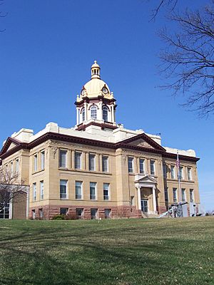
Pierce County Courthouse
|
|

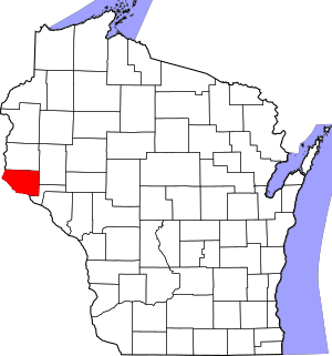
Location within the U.S. state of Wisconsin
|
|
 Wisconsin's location within the U.S. |
|
| Country | |
| State | |
| Founded | 1853 |
| Named for | Franklin Pierce |
| Seat | Ellsworth |
| Largest city | River Falls |
| Area | |
| • Total | 592 sq mi (1,530 km2) |
| • Land | 574 sq mi (1,490 km2) |
| • Water | 18 sq mi (50 km2) 3.1%% |
| Population
(2020)
|
|
| • Total | 42,212 |
| • Estimate
(2023)
|
43,026 |
| • Density | 71.30/sq mi (27.531/km2) |
| Time zone | UTC−6 (Central) |
| • Summer (DST) | UTC−5 (CDT) |
| Congressional district | 3rd |
Pierce County is a county in the U.S. state of Wisconsin. As of the 2020 census, the population was 42,212. Its county seat is Ellsworth. Pierce County is part of the Minneapolis–St. Paul–Bloomington, MN-WI Metropolitan Statistical Area.
Contents
History
Native American were the first to live in what became Pierce County, as evidenced in the burial mounds near Diamond Bluff. Evidence indicates that this area has been inhabited for 10,000 to 12,000 years. In 1840, St. Croix County covered a large portion of northwest Wisconsin Territory. In 1853, the Wisconsin State Legislature split St. Croix County into Pierce, Polk, and Saint Croix counties. Pierce County was named for Franklin Pierce, the fourteenth president of the United States.
Geography
According to the U.S. Census Bureau, the county has a total area of 592 square miles (1,530 km2), of which 574 square miles (1,490 km2) is land and 18 square miles (47 km2) (3.1%) is water.
Adjacent counties
- St. Croix County – north
- Dunn County – northeast
- Pepin County – southeast
- Goodhue County, Minnesota – south
- Dakota County, Minnesota – southwest
- Washington County, Minnesota – west
National protected area
Demographics
| Historical population | |||
|---|---|---|---|
| Census | Pop. | %± | |
| 1860 | 4,672 | — | |
| 1870 | 9,958 | 113.1% | |
| 1880 | 17,744 | 78.2% | |
| 1890 | 20,385 | 14.9% | |
| 1900 | 23,943 | 17.5% | |
| 1910 | 22,079 | −7.8% | |
| 1920 | 21,663 | −1.9% | |
| 1930 | 21,043 | −2.9% | |
| 1940 | 21,471 | 2.0% | |
| 1950 | 21,448 | −0.1% | |
| 1960 | 22,503 | 4.9% | |
| 1970 | 26,652 | 18.4% | |
| 1980 | 31,149 | 16.9% | |
| 1990 | 32,765 | 5.2% | |
| 2000 | 36,804 | 12.3% | |
| 2010 | 41,019 | 11.5% | |
| 2020 | 42,212 | 2.9% | |
| U.S. Decennial Census 1790–1960 1900–1990 1990–2000 2010 2020 |
|||
2020 census
As of the census of 2020, the population was 42,212. The population density was 73.5 people per square mile (28.4 people/km2). There were 16,780 housing units at an average density of 29.2 units per square mile (11.3 units/km2). The racial makeup of the county was 92.3% White, 1.0% Black or African American, 0.7% Asian, 0.5% Native American, 1.1% from other races, and 4.3% from two or more races. Ethnically, the population was 2.9% Hispanic or Latino of any race.
Communities
Cities
- Prescott
- River Falls (partly in St. Croix County)
Villages
- Bay City
- Ellsworth (county seat)
- Elmwood
- Maiden Rock
- Plum City
- Spring Valley (partly in St. Croix County)
Towns
Census-designated places
Unincorporated communities
- Beldenville
- El Paso
- Esdaile
- Exile
- Hatchville (partial)
- Lawton
- Lund
- Martell
- Moeville
- Morton Corner
- Nerike
- North Red Wing
- Oakridge
- Olivet
- Ono
- Ottman Corners
- Pucketville
- Rock Elm
- Salem
- Smith Landing
- Snows Corner
- Trenton
- Trimbelle
- Viking (partial)
- Warrentown
- Waverly
Ghost town/neighborhood
- Brasington
Transportation
Railroads
Buses
See also
 In Spanish: Condado de Pierce (Wisconsin) para niños


