Ruiselede facts for kids
Quick facts for kids
Ruiselede
|
|||
|---|---|---|---|

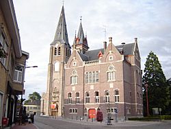
Village centre, with town hall and church of Our Lady
|
|||
|
|||
| Country | Belgium | ||
| Community | Flemish Community | ||
| Region | Flemish Region | ||
| Province | West Flanders | ||
| Arrondissement | Tielt | ||
| Area | |||
| • Total | 30.20 km2 (11.66 sq mi) | ||
| Population
(2018-01-01)Lua error in Module:Wd at line 1575: attempt to index field 'wikibase' (a nil value).
|
|||
| • Total | Lua error in Module:Wd at line 1,575: attempt to index field 'wikibase' (a nil value). | ||
| Postal codes |
8755
|
||
| Area codes | 051 | ||
| Website | www.ruiselede.be | ||
Ruiselede (Dutch pronunciation: [ˈrœysəˌleːdə]; West Flemish: Ruuslee; historically Ruysselede) is a municipality located in the Belgian province of West Flanders. This town only comprises the town of Ruiselede proper. On January 1, 2006, Ruiselede had a total population of 5,113. The total area is 30.20 km2 which gives a population density of 169 inhabitants per km2.
Ruiselede was the location of a coastal radio site. From 1923 to 1940 it had a VLF aerial. On 30 December 1933, the mast was demolished when an aircraft collided with it.
Gallery
See also
 In Spanish: Ruiselede para niños

All content from Kiddle encyclopedia articles (including the article images and facts) can be freely used under Attribution-ShareAlike license, unless stated otherwise. Cite this article:
Ruiselede Facts for Kids. Kiddle Encyclopedia.


