Rocky River (North Carolina) facts for kids
Quick facts for kids Rocky River |
|
|---|---|

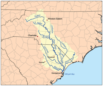
Map of the Pee Dee River watershed showing the Rocky River
|
|
|
Location of Rocky River mouth
|
|
| Other name(s) | Tributary to Pee Dee River |
| Country | United States |
| State | North Carolina |
| County | Anson Cabarrus Iredell Mecklenburg Richmond Stanly Union |
| Physical characteristics | |
| Main source | divide between Rocky River and Catawba River Mooresville, North Carolina 885 ft (270 m) 35°35′01″N 080°47′15″W / 35.58361°N 80.78750°W |
| River mouth | Pee Dee River about 3 miles northeast of Ansonville, North Carolina 190 ft (58 m) 35°08′36″N 080°04′35″W / 35.14333°N 80.07639°W |
| Length | 94.16 mi (151.54 km) |
| Basin features | |
| Progression | generally southeast |
| River system | Pee Dee River |
| Basin size | 1,471.3 square miles (3,811 km2) |
| Tributaries |
|
The Rocky River is a 95-mile-long (153 km) river in the Piedmont region of North Carolina. It begins in Iredell County near Mooresville and flows south into Cabarrus County, where it is the principal waterway in the county. The river continues southeastward to form the line between Stanly, Union, and Anson counties. It empties into the Pee Dee River just below Norwood, North Carolina at the junction of Stanly, Montgomery, Anson, and Richmond counties, at the foot of the Uwharrie Mountains.
Efforts are being made to boost tourism and canoe and kayak recreation along Rocky River "Blueway" as part of the Carolina Thread Trail.
Private, non-profit organizations have developed park lands for improved river access, but some controversy ensued.

All content from Kiddle encyclopedia articles (including the article images and facts) can be freely used under Attribution-ShareAlike license, unless stated otherwise. Cite this article:
Rocky River (North Carolina) Facts for Kids. Kiddle Encyclopedia.

