Union County, North Carolina facts for kids
Quick facts for kids
Union County
|
|||||
|---|---|---|---|---|---|

Union County Courthouse in Monroe
|
|||||
|
|||||
| Motto(s):
"Plant your future."
|
|||||

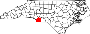
Location within the U.S. state of North Carolina
|
|||||
 North Carolina's location within the U.S. |
|||||
| Country | |||||
| State | |||||
| Founded | 1842 | ||||
| Named for | Compromise name that both local Democrats and Whigs agreed on | ||||
| Seat | Monroe | ||||
| Largest community | Indian Trail | ||||
| Area | |||||
| • Total | 639.65 sq mi (1,656.7 km2) | ||||
| • Land | 632.74 sq mi (1,638.8 km2) | ||||
| • Water | 6.91 sq mi (17.9 km2) 1.08% | ||||
| Population
(2020)
|
|||||
| • Total | 238,267 | ||||
| • Estimate
(2023)
|
256,452 | ||||
| • Density | 376.56/sq mi (145.39/km2) | ||||
| Time zone | UTC−5 (Eastern) | ||||
| • Summer (DST) | UTC−4 (EDT) | ||||
| Congressional districts | 8th | ||||
Union County is a county located in the U.S. state of North Carolina. As of the 2020 census, the population was 238,267. Its county seat is Monroe. Union County is included in the Charlotte-Concord-Gastonia, NC-SC Metropolitan Statistical Area.
Contents
History
The county was formed in 1842 from parts of Anson County and Mecklenburg County. Its name was a compromise between Whigs, who wanted to name the new county for Henry Clay, and Democrats, who wanted to name it for Andrew Jackson. The Helms, Starnes, McRorie, and Belk families took a major part in the Monroe and Charlotte, North Carolina. Most of these families came from Goose Creek Township.
Monroe, the county seat of Union County, also became a focal point during the Civil Rights Movement. In 1958, local NAACP Chapter President Robert F. Williams defended a nine-year-old African-American boy who had been kissed by a white girl in an incident known as the Kissing Case. A second African-American boy, aged seven, was also convicted and sentenced to live in a juvenile reformatory until he was 21 for simply witnessing the act. In 1961, Williams was accused of kidnapping an elderly white couple, when he sheltered them in his house during a very explosive situation of high racial tensions. Williams fled and went into exile in Cuba and in the People's Republic of China before returning to the United States.
Geography
According to the U.S. Census Bureau, the county has a total area of 640 square miles (1,700 km2), of which 632 square miles (1,640 km2) is land and 8.0 square miles (21 km2) (1.3%) is water.
Adjacent counties
- Cabarrus County - north
- Stanly County - northeast
- Anson County - east
- Chesterfield County, South Carolina - southeast
- Lancaster County, South Carolina - southwest
- Mecklenburg County - northwest
Major highways
 US 74
US 74 US 601
 NC 16
NC 16 NC 75
NC 75 NC 84
NC 84 NC 200
 NC 205
 NC 207
 NC 218
 NC 522
 NC 742
 NC 51
NC 51
Demographics
| Historical population | |||
|---|---|---|---|
| Census | Pop. | %± | |
| 1850 | 10,051 | — | |
| 1860 | 11,202 | 11.5% | |
| 1870 | 12,217 | 9.1% | |
| 1880 | 18,056 | 47.8% | |
| 1890 | 21,259 | 17.7% | |
| 1900 | 27,156 | 27.7% | |
| 1910 | 33,277 | 22.5% | |
| 1920 | 36,029 | 8.3% | |
| 1930 | 40,979 | 13.7% | |
| 1940 | 39,097 | −4.6% | |
| 1950 | 42,034 | 7.5% | |
| 1960 | 44,670 | 6.3% | |
| 1970 | 54,714 | 22.5% | |
| 1980 | 70,380 | 28.6% | |
| 1990 | 84,211 | 19.7% | |
| 2000 | 123,677 | 46.9% | |
| 2010 | 201,292 | 62.8% | |
| 2020 | 238,267 | 18.4% | |
| 2023 (est.) | 256,452 | 27.4% | |
| U.S. Decennial Census 1790–1960 1900–1990 1990–2000 2010–2020 |
|||
2020 census
| Race | Number | Percentage |
|---|---|---|
| White (non-Hispanic) | 161,113 | 67.62% |
| Black or African American (non-Hispanic) | 26,500 | 11.12% |
| Native American | 641 | 0.27% |
| Asian | 9,516 | 3.99% |
| Pacific Islander | 90 | 0.04% |
| Other/Mixed | 10,297 | 4.32% |
| Hispanic or Latino | 30,110 | 12.64% |
As of the 2020 United States census, there were 238,267 people, 77,954 households, and 62,932 families residing in the county.
2010 census
As of the census of 2010, there were 201,292 people, 67,864 households, and 54,019 families residing in the county. The population density was 194 people per square mile (75/km2). There were 45,695 housing units at an average density of 31.4 per square mile (12.3/km2). The racial makeup of the county was 79.0% White, 11.7% Black or African American, 0.4% Native American, 1.6% Asian, 0.03% Pacific Islander, 5.3% from other races, and 1.9% from two or more races. 10.4% of the population were Hispanic or Latino of any race.
There were 67,864 households, out of which 42.1% had children under the age of 18 living with them, 64.60% were married couples living together, and 10.70% had a female householder with no husband present. 6.10% had someone living alone who was 65 years of age or older. The average household size was 2.94 and the average family size was 3.3.
In the county, the population was spread out, with 32.90% under the age of 20, 4.7% from 20 to 24, 27.7% from 25 to 44, 25.2% from 45 to 64, and 9.6% who were 65 years of age or older. The median age was 36.2 years. The population was 49.4% male. Northern Union County has the southern foothills of the Uwharrie Mountains
Education
- South Piedmont Community College
- Central Academy of Technology and Arts
- Cuthbertson High School
- Forest Hills High School
- Marvin Ridge High School
- Metrolina Christian Academy
- Monroe Charter Academy
- Monroe High School
- Parkwood High School
- Piedmont High School
- Porter Ridge High School
- Sun Valley High School
- Arborbrook Christian Academy
- Tabernacle Christian School
- Union County Early College
- Union Academy
- Weddington High School
- Wingate University
- Shiloh Elementary
Events
Two major annual events occur in the county:
- Brooklandwood in Mineral Springs is the site of the Queens Cup Steeplechase, one of steeplechase horse racing's major annual events. The program consists of several races, and is held the last Saturday of April. The schedule of events also features a Jack Russell Terrier judging contest. Over 10,000 people typically attend the event.
- The Union County town of Marshville is the site of the Randy Travis Festival, an annual street fair and carnival that takes place every fall.
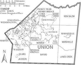
Communities
City
- Monroe (county seat)
Towns
Villages
- Lake Park
- Marvin
- Wesley Chapel
Census-designated place
Unincorporated communities
Ghost towns
Townships
- Goose Creek
- Jackson
- Marshville
- Monroe
- New Salem
- Vance
- Buford
- Lanes Creek
- Sandy Ridge
See also
 In Spanish: Condado de Union (Carolina del Norte) para niños


