Randolph County, North Carolina facts for kids
Quick facts for kids
Randolph County
|
|||||
|---|---|---|---|---|---|

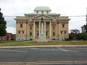
Randolph County Courthouse and Confederate Monument
|
|||||
|
|||||
| Motto(s):
"Serving with Heart from the Heart of North Carolina"
|
|||||

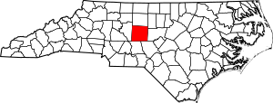
Location within the U.S. state of North Carolina
|
|||||
 North Carolina's location within the U.S. |
|||||
| Country | |||||
| State | |||||
| Founded | 1779 | ||||
| Named for | Peyton Randolph | ||||
| Seat | Asheboro | ||||
| Largest community | Asheboro | ||||
| Area | |||||
| • Total | 790.01 sq mi (2,046.1 km2) | ||||
| • Land | 782.38 sq mi (2,026.4 km2) | ||||
| • Water | 7.63 sq mi (19.8 km2) 0.97% | ||||
| Population
(2020)
|
|||||
| • Total | 144,171 | ||||
| • Estimate
(2023)
|
147,458 | ||||
| • Density | 184.27/sq mi (71.15/km2) | ||||
| Time zone | UTC−5 (Eastern) | ||||
| • Summer (DST) | UTC−4 (EDT) | ||||
| Congressional district | 9th | ||||
Randolph County is a county located in the U.S. state of North Carolina. As of the 2020 census, the population was 144,171. Its county seat is Asheboro.
Randolph County is included in the Greensboro-High Point, NC Metropolitan Statistical Area, which is also included in the Greensboro–Winston-Salem–High Point, NC Combined Statistical Area.
In 2020, the center of population of North Carolina was located in Randolph County, east of Seagrove.
Contents
History
The area which eventually became known as Randolph county was originally inhabited by Siouan Native Americans including Saponi and Keyauwee. In the 1700s, European settlers moved into the area, namely Germans, Scotch-Irish, and English, some of whom were Quakers and Moravians. The Legislature of 1779, then sitting at Halifax, passed an act providing for the formation of a new county from parts of Guilford and Rowan, to be called Randolph. It was named for Peyton Randolph, first president of the Continental Congress.
In the antebellum period, Randolph County was economically poor and characterized by smallholding farmers.
The outbreak of the American Civil War caused division in the county. Many resident Quakers were pacifists and opposed to the war, while poorer conscripts resented being detailed to the frontlines while wealthier militia officers were frequently exempted from such service, leading to many refusing to muster out. In the 1864 gubernatorial election, Randolph was one of only three counties in the state to supply a majority of its votes to William Woods Holden, who was running on a peace platform. A substantial number of men drafted to serve in the Confederate Army from Randolph deserted and were kept hidden with assistance of the anti-Confederate Heroes of America, leading the state government to order operations in 1863 to detain them. The activity of deserters was curtailed by late 1864, though it increased in early 1865, with widespread reports of theft and robbery. Many local members of the Confederate Home Guard grew fearful of enforcing conscription, and some of the body's leaders doubted their subordinates' loyalty. To ease tensions, the state government dispatched 600 troops to the county in March and offered terms to the deserters.
After the war, the county's government became dominated by men who had supported the Union, and some used their new positions of power to enact revenge on those who had enforced the conscription law. Between 1868 and 1872, the white supremacist and reactionary Ku Klux Klan was active throughout much of North Carolina's Piedmont counties, including Randolph. Despite the Klan's activity, most whites in Randolph remained supportive of the Republican Party.
Randolph's textile industry expanded after the war with the establishment of new mills along the Deep River.
In 1911, a new county called Piedmont County was proposed, with High Point as its county seat, to be created from Guilford, Davidson, and Randolph counties. Many people appeared at the Guilford County courthouse to oppose the plan, vowing to go to the state legislature to protest. The state legislature voted down the plan in February 1911.
Geography
According to the U.S. Census Bureau, the county has a total area of 790.01 square miles (2,046.1 km2), of which 782.38 square miles (2,026.4 km2) is land and 7.63 square miles (19.8 km2) (0.97%) is water. It is bordered by Guilford County, Alamance County, Chatham County, Moore County, Montgomery County, and Davidson County.
Randolph County is located in the center of North Carolina, and the city of Asheboro (in the county) is the center point of North Carolina. Randolph County is located in the Piedmont section of central North Carolina, generally a region of gently rolling hills and woodlands. The central and western parts of the county contain the Uwharrie Mountains and the Caraway Mountains. These two ranges are the remnants of a much-higher range of ancient peaks. Today, they rarely top 1,000 feet (300 m) above sea level, yet due to the relative low terrain around them, they still rise 200–500 feet (61–152 m) above their base.
The highest point in Randolph County is Shepherd Mountain, a peak in the Caraways. The North Carolina Zoo is located atop Purgatory Mountain, one of the peaks of the Uwharries.
National protected area
- Birkhead Mountains Wilderness
- Uwharrie National Forest
State and local protected areas/sites
- North Carolina Zoo
- Pisgah Covered Bridge
- Uwharrie Game Land (part)
Major water bodies
- Back Creek
- Bush Creek
- Caraway Creek
- Deep River
- Little Caraway Creek
- Little River
- Little Uwharrie River
- Randleman Lake
- Reed Creek
- Rocky River
- Toms Creek
- Uwharrie River
Major highways
 I-73
I-73 I-74
I-74 I-85
I-85


 Future I-685
 US 29
US 29 US 64
US 64
 US 64 Bus.
 US 70
US 70 US 220


 US 220 Alt.


 US 220 Bus.
 US 311
 US 421
 NC 22
NC 22 NC 42
NC 42 NC 47
NC 47 NC 49
NC 49 NC 62
NC 62 NC 109
 NC 134
 NC 159
 NC 159 Spur (spur route)
 NC 705
Major infrastructure
- Asheboro Regional Airport
Demographics
| Historical population | |||
|---|---|---|---|
| Census | Pop. | %± | |
| 1790 | 7,318 | — | |
| 1800 | 9,234 | 26.2% | |
| 1810 | 10,112 | 9.5% | |
| 1820 | 11,331 | 12.1% | |
| 1830 | 12,406 | 9.5% | |
| 1840 | 12,875 | 3.8% | |
| 1850 | 15,832 | 23.0% | |
| 1860 | 16,793 | 6.1% | |
| 1870 | 17,551 | 4.5% | |
| 1880 | 20,836 | 18.7% | |
| 1890 | 25,195 | 20.9% | |
| 1900 | 28,232 | 12.1% | |
| 1910 | 29,491 | 4.5% | |
| 1920 | 30,856 | 4.6% | |
| 1930 | 36,259 | 17.5% | |
| 1940 | 44,554 | 22.9% | |
| 1950 | 50,804 | 14.0% | |
| 1960 | 61,497 | 21.0% | |
| 1970 | 76,358 | 24.2% | |
| 1980 | 91,728 | 20.1% | |
| 1990 | 106,546 | 16.2% | |
| 2000 | 130,454 | 22.4% | |
| 2010 | 141,752 | 8.7% | |
| 2020 | 144,171 | 1.7% | |
| 2023 (est.) | 147,458 | 4.0% | |
| U.S. Decennial Census 1790–1960 1900–1990 1990–2000 2010 2020 |
|||
2020 census
| Race | Number | Percentage |
|---|---|---|
| White (non-Hispanic) | 108,354 | 75.16% |
| Black or African American (non-Hispanic) | 8,592 | 5.96% |
| Native American | 666 | 0.46% |
| Asian | 2,158 | 1.5% |
| Pacific Islander | 10 | 0.01% |
| Other/Mixed | 5,340 | 3.7% |
| Hispanic or Latino | 19,051 | 13.21% |
As of the 2020 census, there were 144,171 people, 56,117 households, and 37,795 families residing in the county.
Economy
Randolph's economy is largely based in manufacturing. In its 2024 county economic tier ratings, the North Carolina Department of Commerce classified Randolph as among the state's 20 least economically distressed counties, or "tier 1".
Education
Randolph County School System serves most of the county. The city of Asheboro is managed separately by Asheboro City Schools.
Fayetteville Street Christian School, located in Asheboro, is the largest private school in Randolph County.
Culture
Pottery-making has long been popular in the Seagrove area of Randolph County, and is annually celebrated in the Seagrove Pottery Festival.
Communities
Cities
- Archdale (part)
- Asheboro (county seat and largest community)
- High Point (part)
- Randleman
- Thomasville (part)
- Trinity
Towns
Townships
- Asheboro
- Archdale
- Back Creek
- Brower
- Cedar Grove
- Coleridge
- Columbia
- Concord
- Farmer
- Franklinville
- Grant
- Level Cross
- Liberty
- New Hope
- New Market
- Pleasant Grove
- Providence
- Randleman
- Richland
- Tabernacle
- Trinity
- Union
Unincorporated communities
Notable people
- Sam Ard, NASCAR driver
- Jerry Bledsoe, author
- Heidi N Closet, drag queen
- Braxton Craven, educator and second president of Duke University
- Heaven Fitch, wrestler
- Rufus Hussey, marksman
- Henderson Luelling, Quaker abolitionist, horticulturist
- Gideon Morris, trans-Appalachian pioneer and founder of Morristown, Tennessee
- Adam Petty, NASCAR driver
- Kyle Petty, NASCAR driver
- Lee Petty, NASCAR pioneer
- Richard Petty, NASCAR driver
- Naomi Wise, murder victim
- Jonathan Worth, former Governor of North Carolina (1865–1868)
See also
 In Spanish: Condado de Randolph (Carolina del Norte) para niños


